
Michigan Memories: Aerial views of University of Michigan from over the century
What a difference a century makes.
Dozens of iconic University of Michigan buildings —the Michigan Union, the Law Quadrangle, Angell Hall, the Burton Memorial Bell Tower, Hill Auditorium— have speckled Ann Arbor in the last century, although they are so ingrained into the city landscape they seem, at times, to have sprung up with the trees.
Michigan Union was built in 1917 for $1.15 million; the Law Quadrangle dedicated in 1935; Angell Hall built in 1924 for $1.08 million; the bell tower built in 1936 for $150,000; and Hill Auditorium completed in 1913 for $347,600, according to the U-M Bentley Historical Library.
Over the century, the university built legacy dorms in the Hill Neighborhood, drastically expanded its health campus, added museums, auditoriums and classroom buildings to its central campus, built the largest stadium in the nation on its athletic campus, and sprouted a new campus north of its original centrally located campus.
Generations of Ann Arbor residents have watched the campus, and in turn the city, evolve.
When the City of Ann Arbor cast the winning bid for U-M to relocate to the city in 1837, city leaders knew the school would be key to the economic vitality of the fledgling metropolis. But did they foresee just how much the university's infrastructure would spread out from and build upon its original 40-acre plot and change the economic, intellectual and physical make up of the city?
AnnArbor.com has collected some aerial shots of the U-M campus, dating as far back as 1928, so readers can experience some of the physical transformation. If you have aerial photos of the campus, please post links in the comment section.
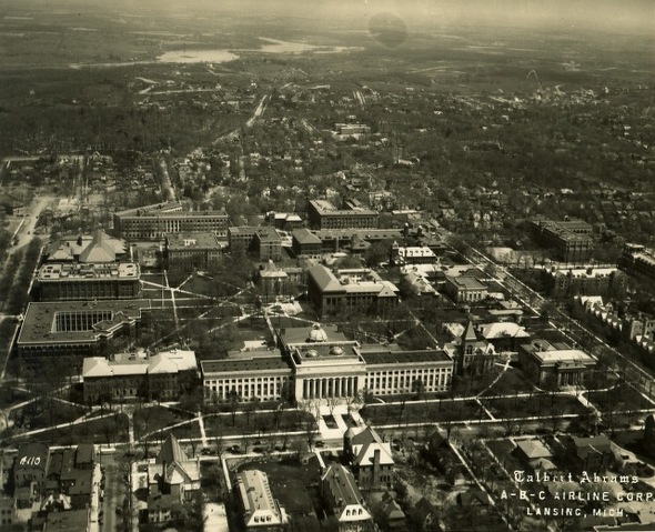
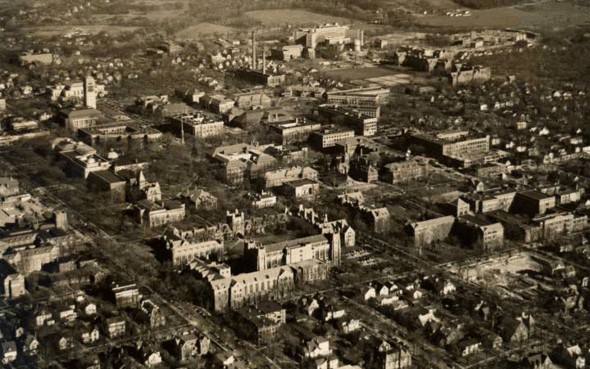
Aerial shot of the U-M Diag area during 1928.
Photo courtesy of University of Michigan Bentley Historical Library.
An aerial view of campus circa 1930-31.
University of Michigan Bentley Historical Library
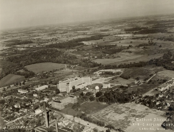
Aerial shot from the southwest of the hospital in 1931.
Photo courtesy of University of Michigan Bentley Historical Library.
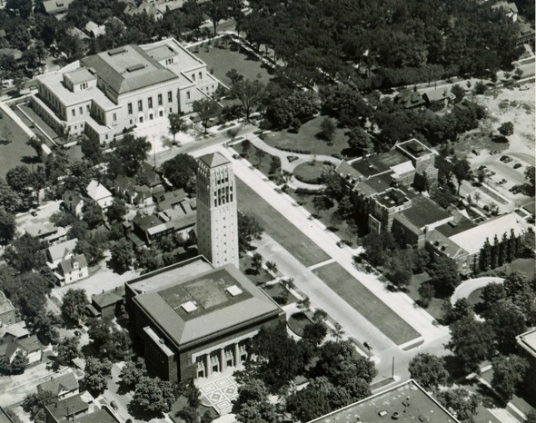
Photo courtesy of University of Michigan Bentley Historical Library.
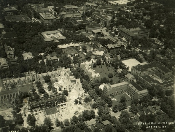
University of Michigan central campus in 1940.
Photo courtesy of Bentley Historical Library
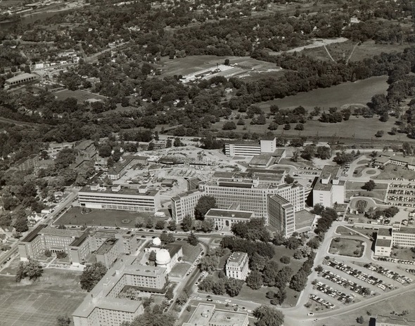
An aerial shot of U-M's Medical Campus during 1958.
Photo courtesy of University of Michigan Bentley Historical Library.
1968 aerial shot of medical center from east.
Photo courtesy of University of Michigan Bentley Historical Library.
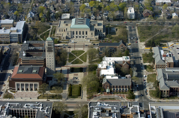
Aerial view of University of Michigan in Ann Arbor on Tuesday, April 19, 2005.
Ann Arbor News file photo
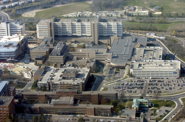
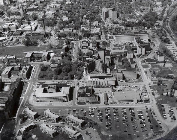
University of Michigan Medical Campus in 2005.
Ann Arbor News file photo
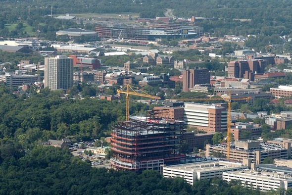
The new C.S. Mott Hospital facility under construction in 2008.
AnnArbor.com file photo
Kellie Woodhouse covers higher education for AnnArbor.com. Reach her at kelliewoodhouse@annarbor.com or 734-623-4602 and follow her on twitter.
Comments
Lankthy
Tue, Jun 19, 2012 : 1:02 a.m.
Thanks for doing these pieces
David Knisely
Tue, Jun 19, 2012 : 12:55 a.m.
Great pictures. I've been looking for the UM Contagious Hospital where I was with other polio patients in 1949. It was near the old hospital. I believe it was previously a laundry facility. I don't see it in these photos.
Mike S
Tue, Jun 19, 2012 : 1:52 a.m.
Have you tried the image bank at http://bentley.umich.edu/ ?
Jeff Renner
Sun, Jun 17, 2012 : 11:49 p.m.
I like the '68 photo of the Medical Center with University Terrace married housing in the foreground. We lived there in '68, so maybe one of those cars in the parking lot is our brand new '68 Dodge Dart!
Harm
Sun, Jun 17, 2012 : 8:57 p.m.
Thank you, annarbor.com.....
MRunner73
Sun, Jun 17, 2012 : 3:45 p.m.
What's amazing is how the landscape changes have accelerated during just the past 10 years. The pictorial views from the air are really cool. There are books out loaded with photos of the University and Ann Arbor taken back to the 1870s. Always fascinating.
Tru2Blu76
Sun, Jun 17, 2012 : 2:57 p.m.
I would bet that, over the last six years, there have been more changes to the Ann Arbor / U of M landscape & skyline than in the previous 100 years. Missed opportunity: several times, I thought it would make a useful archive to take aerial and ground level shots of this area in order to record this growth. I have attempted to do my own version but, obviously, was limited in funds for that purpose. The best I have is one long video of the demolition of the old YMCA building with includes a slo-mo sequence of the collapse of the final (S.W.) portion of that building. I also have a panorama shot (somewhere) taken from the top of the William and Fourth Parking Structure which shows 13 construction cranes on our skyline. I've just added to the mini-series I'm doing with photos & video of the new underground parking structure, showing newly opened Fifth Ave. I also did photos & video when I attended the open house for the renovated Michigan Stadium. I guess I have quite an archive, maybe Bentley Library would be interested in copies of some of these photos?
MRunner73
Sun, Jun 17, 2012 : 3:47 p.m.
Yes, indeed.. thanks.
ChrisW
Sun, Jun 17, 2012 : 2:35 p.m.
I would love to see these images side-by-side with modern ones taken from the same position. Something like WhatWasThere.com but with aerial photographs.
J-smith
Sun, Jun 17, 2012 : 1:51 p.m.
very cool. Thank you.
Townie
Sun, Jun 17, 2012 : 12:58 p.m.
How about a link to larger images?