
New roundabout and crosswalks among options for improving Ann Arbor's North Main corridor
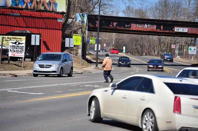
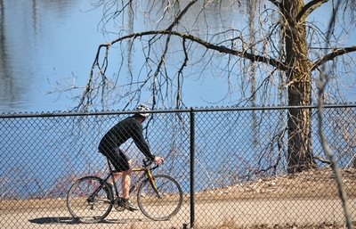
A pedestrian makes a risky run through four lanes of fast-moving traffic to cross North Main Street north of Depot Street in Ann Arbor on Friday. North of Summit Street, there isn't a single crosswalk along the entire stretch of North Main for roughly three quarters of a mile before it turns into M-14. AnnArbor.com witnessed other people crossing the road in a similar manner.
Ryan J. Stanton | AnnArbor.com
The corridor is riddled with blight, lacks basic amenities for pedestrians and bicyclists, and fast-moving traffic can make getting from one side of the road to the other a formidable task.
"It's got to be one of the top hazardous areas of Ann Arbor," said George Creswell, an employee at Main Street Motors at the corner of North Main and Depot Street.
Creswell spoke with AnnArbor.com on Friday after making his way across Main Street without the aid of a crosswalk by doing what many people have to do — wait for a gap in traffic, and go for it.
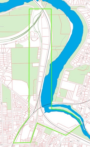
A map of the area being studied by the city's citizen-led North Main-Huron River Corridor Vision Task Force.
City of Ann Arbor
The city's citizen-led North Main-Huron River Corridor Vision Task Force has been meeting for months and is starting to form a conceptual plan for solving those sorts of problems, while at the same time improving access to nearby recreational amenities along the Huron River.
Some of the ideas emerging: new crosswalks and traffic signals, a roundabout for traffic coming off the highway onto North Main, a park-and-ride lot off M-14 to take more cars off the road, bicycle lanes, new sidewalks on both sides of the road, improved lighting and signage, a pedestrian bridge over North Main, and a pedestrian tunnel under the railroad tracks north of Depot Street.
North of Summit Street, there isn't a single crosswalk along the entire stretch of North Main for roughly three quarters of a mile before it turns into M-14, creating a divide between popular nature areas to the west and riverside recreation amenities to the east.
Another barrier to those amenities is the railroad that runs along the south and west side of the river, with only one legal crossing at Lake Shore Drive — which also is at risk of closing.
Task force members believe the corridor should reflect Ann Arbor's civic pride in everything from landscaping to road design, complete with wayfinding signs and nonmotorized paths.
Rather than just an automobile-oriented thoroughfare cars race through to get in and out of town, there's a desire to make North Main a destination and give people a reason to slow down.
"This is not a complete street by any means. This is a highway entrance ramp," said Doug Allen, a property manager for Peter Allen and Associates, which owns a number of properties along North Main, including the Riverfront Building at 1250 N. Main St.
Allen spoke with AnnArbor.com outside the Riverfront Building on Friday. He said he's doing his part to beautify his own properties, including the recent installation of an "art fence" painted different colors with an image of a snake on one side. He also made a galvanized steel sign that lights up at night.
"We've got five properties on North Main, and so we're just trying to do our little bit with our properties, and we totally would enjoy more help from the city in making this a safe, inviting entryway to Ann Arbor," he said. "I'm trying to do it with art, class, nice buildings and nice architecture lit at night."
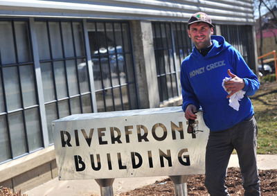
Doug Allen, a property manager for Peter Allen and Associates, which owns a number of properties along North Main, stands in front of the galvanized steel sign he recently made for the Riverfront Building at 1250 N. Main St. "We've got five properties on North Main, and so we're just trying to do our little bit with our properties, and we totally would enjoy more help from the city in making this a safe, inviting entryway to Ann Arbor," he said.
Ryan J. Stanton | AnnArbor.com
There has been mention of a potential tax-increment financing zone to fund some of the improvements along the corridor that the task force is talking about.
One idea aimed at calming traffic on North Main is a new roundabout where M-14 and Huron River Drive become Main Street at the far north end of the corridor.
"We think that might be a good idea," said City Council Member Sabra Briere, D-1st Ward, the lone council member on the citizen task force.
Another idea being discussed is a park-and-ride lot at M-14 and Barton Drive, where there's a highway on- and off-ramp near Bandemer Park. The idea is that buses could pick up commuters and head down Barton Drive toward Pontiac Trail and into town, taking traffic off North Main.
"The goal here is to make bike lanes safe, to provide a better environment for bus service, and to encourage pedestrians to use the sidewalk, which they aren't right now," Briere said.
Another idea mentioned at the last task force meeting is a user-activated HAWK signal where Lake Shore Drive meets North Main.
That would allow pedestrians and bicyclists to safely cross North Main, including people going between Bluffs Park to the west and Bandemer Park and the Border-to-Border Trail to the east.
"I love it," agreed David Santacroce, the task force's chairman.
Briere's subcommittee believes the city should create well-defined pedestrian and bike paths through the Bluffs, leading to the proposed crosswalk at North Main at Lake Shore Drive. She said there might even be opportunities to work with the terrain to create vistas of the river.
"You've got some great views through the trees," she said. "It would be possible to emphasize those views as part of how you anticipate the river."
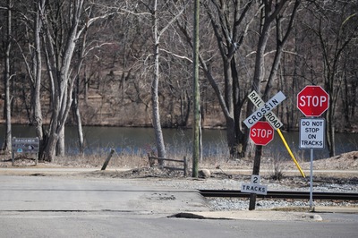
Task force members fear the Michigan Department of Transportation, which acquired the tracks from Norfolk Southern, could close this at-grade crossing at Lake Shore Drive off North Main when it implements high-speed rail. "The railroad is a big barrier getting people to the amenities," said David Santacroce, the task force's chairman. "That's an important access point."
Ryan J. Stanton | AnnArbor.com
Task force members fear the Michigan Department of Transportation, which acquired the tracks from Norfolk Southern, could close the crossing when it implements high-speed rail.
"Everything we talked about doing is to funnel bikes and pedestrians somehow to the Lake Shore entrance to the park because we think Lake Shore should remain open," Briere said, suggesting the crossing could be improved with fencing and gates as the city looks for another solution.
"One long-term solution is to build a pedestrian bridge over Main Street or over Depot and the railroad tracks," she said. "We also think it's possible to build a tunnel adjacent to Depot Street."
Task force member Tamara Burns said her subcommittee, which focused on riverside amenities, likes the idea of trying to keep the Lake Shore Drive crossing open as long as possible, but she said it seems clear it's definitely going to close at some point.
"And I don't have any problem with trying again, but I know they've been trying and trying to put gates there and have not been successful," she said.
Burns said the city has wanted to install signals and gates for years, but that would make it an official public crossing.
"If it is an official public crossing, it has to be closed/removed (or another crossing has to be closed) because there can be no net increase in crossings," her subcommittee report states. "This has still not been solved despite the city's efforts, and it remains a situation no one wants to touch."
The task force is discussing widening the Border-to-Border Trail along the Huron River so there's less conflict between pedestrians and bicycles.
Ryan J. Stanton | AnnArbor.com
It also recommends additional bike racks at the rowing center, rental storage lockers for kayaks/canoes, and annual weed mitigation in the river channel just north of the rowing docks.
Additionally, the report highlights a number of opportunities for improving the Border-to-Border Trail, including adding more trash and recycling receptacles, dog waste stations, a new drinking water station, improved lighting, and benches at scenic overlooks.
Widening the Border-to-Border Trail along the river so there's less conflict between pedestrians and bicycles also is being discussed.
Another task force subcommittee looked at opportunities for easing traffic congestion at Main and Depot at certain times of day.
"We spent a little more time and effort on the getting-out-of-town part, because that seemed to be the bigger issue," said Darren McKinnon, a member of that subcommittee.
Traffic on southbound Main Street backs up in the morning for those trying to turn left at Depot. And in the afternoon, westbound Depot backs up for those trying to turn right at Main.
Task force members said the congestion is frustrating for motorists and creates dangerous situations for pedestrians wishing to pass through the intersection during peak times.
McKinnon's subcommittee recommends installing pedestrian crosswalks across Depot at Fourth Avenue and across Main at Depot to improve safety.
Other short-term solutions include adding a right-turn green arrow for westbound Depot traffic and converting the existing "left turn only" lane on Depot to allow right turns as well, essentially creating a double right-turn lane. Because North Main is a state highway route, the city would have to work with MDOT to implement those kinds of changes.
A truck turns left onto Depot Street from North Main on Friday afternoon. The task force is looking at opportunities for easing traffic congestion at Main and Depot during peak times.
Ryan J. Stanton | AnnArbor.com
McKinnon said the city should consider taking advantage of the vast amount of city-owned property to the west of Main Street to widen the right-of-way.
Task force members have talked about increasing the right-of-way about 15 feet to the west to put in a shared-use bicycle and pedestrian path on the west side of the road. That would require asking some private property owners for use of a portion of their land.
McKinnon's subcommittee also looked at flooding issues, noting the block bordered by Depot/Main/Summit/Fourth is completely within the floodway.
One idea is to have the city purchase those properties over time as they're put up for sale by their owners, and demolish the buildings to remove them from the floodway. Once clear, the extra space could be used to reconstruct the Depot/Main intersection.
Briere's subcommittee recommends the Planning Commission complete a North Main Corridor Improvement Study prior to 2015, so the findings could be used by MDOT in planning improvements along North Main in conjunction with road construction that's scheduled for 2018. The plan could include added lighting and streetscape improvements for pedestrian and nonmotorized use.
Task force members also are concerned about the condition of some properties along North Main, noting they don't exactly provide the most attractive entrance to the city.
"We talked about what could be done to improve options in that area, whether it's looking at the zoning for new construction, whether it's encouraging the property owners to actually maintain a 360-degree awareness of their property and clean it up from the riverside as well as the Main Street side," Briere said. "We think all of those are really valuable options in there."
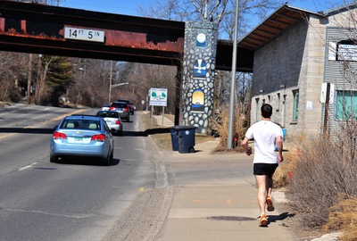
A runner makes his way up the sidewalk on the east side of North Main on Friday. Installing a sidewalk on the west side of Main and improving the sidewalk on the east side of Main are considered major opportunities.
Ryan J. Stanton | AnnArbor.com
Briere said it could be possible for a path that moves from Main Street through the former Allied Building Products property at 1380 N. Main St. and underneath the bridge.
"There should be a bike and pedestrian path adjacent to the M-14 on-ramp and under the M-14 bridge," she said. "And we think well-defined bike and pedestrian paths in Bluffs could lead from Sunset to Huronview for access to either Beechwood or Bird Hills also."
Looking at the bigger picture, task force members see opportunities for new development and economic vitality along the corridor as it undergoes a transformation. And they believe the views of the riverside parks, which they hope to see improved, will be a major selling point.
The task force is working to finalize a set of recommendations that will go to the City Council by July 31. There will be chances to provide input at community meetings on May 22 and June 12 from 6:30 p.m. to 8:30 p.m. at the Ann Arbor Community Center.
Ryan J. Stanton covers government and politics for AnnArbor.com. Reach him at ryanstanton@annarbor.com or 734-623-2529. You also can follow him on Twitter or subscribe to AnnArbor.com's email newsletters.
Comments
Carolyn
Tue, Apr 2, 2013 : 2:53 p.m.
LIGHTED FLASHING OVERHEAD SIGNED crosswalk, roundabout, wider bike lane, right turn signal, slower speeds, SIDEWALKS - all of the above!!!
Patricia Lesko
Mon, Apr 1, 2013 : 8:01 p.m.
"Looking at the bigger picture, task force members see opportunities for new development and economic vitality along the corridor as it undergoes a transformation. And they believe the views of the riverside parks, which they hope to see improved, will be a major selling point." I have no confidence that John Hieftje understands the bigger picture or has the ability to execute successful new development in this area. His efforts thus far? "Task force members also are concerned about the condition of some properties along North Main, noting they don't exactly provide the most attractive entrance to the city." Those properties belong to John Hieftje's political pal Michael Apple. Apple took nonprofit Avalon Housing into the development game with Three Oaks (private developer). The DDA (North Main Task Force member Sandi Smith) tried to steer $500K in taxpayer money to Three Oaks and Avalon to mitigate their expenses. Now, we're spending more time and (possibly) more public money to clean up that mess. How about Avalon and Three Oaks take care of their own blight? Ward 1 Council member Sabra Briere is concerned with saving train tracks. Then, she says a park and ride at M-14 and Barton Drive is a good idea. Seriously? That's Bandemer Park. With thanks to the citizen members of the Task Force, we don't need a Task Force to realize that the crumbling street, uneven, gapped sidewalks along Main between Summit and Lakeshore are evidence of long-term neglect by Ward 1 Council members Briere and Sandi Smith—not to mention John Hieftje. Occam's Razor: fix the sidewalks in this "corridor" (we just approved a millage for sidewalk repair, right?), repave the street as needed, fill the potholes, craft and pass a blight ordinance then enforce it, enforce existing community standards, enforce the existing graffiti ordinance, paint lines for crosswalks where worn. Repeat process all over town.
A2Nut
Mon, Apr 1, 2013 : 4:40 a.m.
Who is responsible for fixing the streets in Ann Arbor? Do we need a study and commission for that? For pedestrians; cross at the light, look both ways. I rarely see pedestrians and bike riders in that area. Put in cross walks, repair the surfaces, leave the rest alone til other streets are repaved. This mad mission to engineer Ann Arbor into a pedestrian, bike riding town is hopeless. If there was a public outcry for this then so be it. There is not. Please stop trying to reshape Ann Arbor for so few people.
Anthony
Mon, Apr 1, 2013 : 3:58 a.m.
there's no way to fix the traffic situation. as you add more lanes it will only get worse. maybe you should abandon the idea that you can live hours away from your workplace. meanwhile try to make life more livable for the more reasonable human beings that inhabit the planet.
Superior Twp voter
Tue, Apr 2, 2013 : 4:58 a.m.
Yes, for a reasonable human being like me. I ride my donkey everywhere I go. I have to feed it, but in turn I can burn its dung for energy. I can work as far away as my donkey can take and return me!
JRW
Mon, Apr 1, 2013 : 3:10 a.m.
A roundabout? You must be joking. If the goal is to make the area more welcoming and pedestrian friendly, then a roundabout is NOT the answer. They are a disaster around this city, tiny little circles where cars don't yield to traffic in the circle and pedestrians have no chance. Forget roundabouts. They are far too small. Start with focusing on getting rid of the blight. That would be a huge step in the right direction. Why are those blighted buildings still standing after all these years of deterioration? At least 15 years have gone by with nothing done about them. Focus on that.
Basic Bob
Mon, Apr 1, 2013 : 2:55 p.m.
The effect of making the roundabout bigger is to make the speeds faster. They could make them 900 feet across banked 26 degrees like Bristol Motor Speedway, and vehicles going too fast will still lose control.
dae
Mon, Apr 1, 2013 : 3:05 a.m.
The Barton-Whitmore Lake exit needs to be revamped, too. That's a big problem with the weave on WB 14 and people coming to a complete stop before entering EB 14. Granted there's restrictions because of the river, but that is a potentially dangerous stretch of road, especially now with the increased speed limit. As for the Main Street project, I'd like to see access to WB 14 from Main and from EB 14 - maybe even via Huron River? That would help inbound traffic. Keep it two lanes both ways and widen to create the bike lanes. Also, do something with that bridge just north of Depot - that looks like it needed something done decades ago! (Also, BUS 23 isn't signed so does it still exist?)
Charley Sullivan
Mon, Apr 1, 2013 : 12:22 a.m.
RIddled with blight? It's been an industrial area, though not one that's particularly ugly if you ask me. Want blight? Try driving in Washtenaw!
Jon Wax
Sun, Mar 31, 2013 : 11:11 p.m.
1. since they raised the speed limit, 2 things have happened: being outdoors during the summer kind of sucks. trying to get out of the driveway is a crap shoot. sorry, but i'm not going from 0 to 50 that fast, just not gonna happen. don't tailgate me for it. 2. lotus can go any time now. those folks are not cool. take it anywhere but here. and those giant fans with ya. you're a european company, yeah? shouldn't you be lowering european air quality instead of ours? 3. a sidewalk on our side of the street? why? you ripping up the fireplugs for that? should be fun. there are so few pedestrians on the sidewalk you have now, why put in another one? 4. the park you guys are talking about dropping in at the auto shop... how's that going to work? 3 way light like over by maple kmart? or should i just go ahead and put the traffic dispatcher on speed dial now? without a light at that spot, you're going to see some serious wreckage. with it, well... see bullet point 1. can we go back to 35 mph, then? 5. how do you beautify a semi industrial area like this? aside from getting rid of the industrial part, what other techniques are there to make n main look pretty? or even not semi industrial? 6. i still think that area should be a boardwalk and the city is missing out on a windfall. if that area was turned into what "downtown" main looks like then you might have reasons to justify all this stuff. but as it is now, i don't think folks are very hype to jump off the freeway then leave their car in a location that is about as nice as you can make it for thieves. just sayin. and then in order to get downtown, they have to figure out some weird bike, walking, bus thing? or you could just stay in your car, roll the extra 5 blocks and use the parking structure? eh... still not sure where all this drive is coming from to push n main on people. there's nothing down here, really. Peace Wax
golfer
Sun, Mar 31, 2013 : 10:54 p.m.
all i can say is there better be lights on them. you should have lights on all crosswalks. even those that currently do not. did not finish the job. seen lots of cars run them when one stops on the left the right side the go through..
Larry Baird
Sun, Mar 31, 2013 : 9:28 p.m.
Why not build a park and ride lot connected to the newly constructed rest area off US 23 north of town? The parking lot could connect to Whitmore Lake Rd, so the evening commuters could exit out onto Whitmore Lake Rd. north and get back on the highway at North Territorial. In addition to an AATA shuttle bus, they could have the AirRide bus from Lansing stop here to pick up commuters. Also, there is plenty more land off Miller and between Maple and Miller to expand park and ride lots in this area. That is only one exit before (or after) N. Main and could service more commuters coming from the east, west and north.
A2M3
Sun, Mar 31, 2013 : 9:01 p.m.
How about the city tries to reclaim that $100K grant they lost and level those houses for a commuter parking lot with shuttle service to downtown? That way people could visit and get a ride back to their car, well unless it was after 8pm, then they are on their own. Why not get a public transportation infrastructure in place that complements the exclusion of autos from downtown?
Basic Bob
Mon, Apr 1, 2013 : 2:10 a.m.
The grant expired. No way to claim it back because they didn't demolish anything.
Tom Joad
Sun, Mar 31, 2013 : 9 p.m.
What could be a crown jewel of river frontage is nothing but an industrial corridor with an extension to the freeway next to it. Just to get over to the bike/pedestrian path and Argo Dam you see dozens of people each day trespassing on railroad property by crossing the tracks at Summit and Main rather than going further down N. Main to Lake Shore Dr. crossing, which I dare say most people do not even know exists. All that park land on either side could be better utilized with sidewalks on both sides and bicycle lanes on N. Main. Bicycle transportation will play a more vital role in the coming years with peak oil and resource depletion. The suburbs are becoming an anachronism with increasing energy costs. The city should be doing everything to encourage public transportation for commuters and getting individuals out of their cars. Reducing N. Main to two lanes is definitely workable because the bottleneck is getting on and off the highway. The entrance ramp is single lane. Traffic doesn't move any faster when everyone is jockeying to get into the right (right) lane to merge onto M-14. And, yes, you can get onto westbound M-14 by just staying in the Barton Dr. exit lane and crossing under the freeway. The most ridiculous entrance ramp in any urban area is having to come to a complete stop on Barton entering eastbound M-14.
Bob
Sun, Mar 31, 2013 : 8:49 p.m.
This area looks like crap, makes me want to turn around and leave Ann Arbor, one of the ugliest parts of a2 and it's a entrance to the city -___-
demistify
Sun, Mar 31, 2013 : 8:15 p.m.
Let us give thanks that state law will not allow bicycles on M-14.
Dirty Mouth
Sun, Mar 31, 2013 : 6:13 p.m.
It is indeed scary how fast traffic zooms through from the highway exit all the way down to Summit. Also, due to the rapid speeds and lack of safe bicycle paths, access to the nearby parks and Huron River Drive are impeded. Also, the abandoned and blighted properties all along Main street from Summit up through Miller are pretty hideous and a frequent topic of conversations among visitors to the mayor's city.
yohan
Mon, Apr 1, 2013 : 12:35 a.m.
D.Mouth said "among visitors to the mayor's city." The MAYOR'S CITY ... really THE MAYOR'S CITY??!?!!? OK that has been my problem all along. I always assumed that the city belonged to ALL of the people. Now I realize that it belongs to the mayor. He sure does act like it all belongs to hizzzoner.
uabchris
Sun, Mar 31, 2013 : 5:32 p.m.
The City should focus on one of our greatest amenities, THE RIVER, which most cities could only dream to have as a focal point. Develop that area on the river as an extension of downtown and git rid of all the blight and industrial dilapidation...that area has Soo much potential!
Stephen Lange Ranzini
Mon, Apr 1, 2013 : 2:26 a.m.
If we do make a good bike trail connection between N. Main at Depot and at the end of N. Main at M-14 to the bicycle trail along the Huron River from W. Huron River Drive, this will significantly enhance this major amenity and provide an economic benefit to our area. It will also encourage the private sector to invest in these dilapidated properties since they will have excellent access to this awesome bike trail along the river. This would provide a strong benefit to the owners of the buildings that would benefit, & a local improvement district could pay for some of the cost equal to the benefit they receive & the city should find the money from a lower priority elsewhere if federal or state funding is not available. Constructing more of the Border to Border Trail with excellent access from Main St. will be an economic boon to the city. Microsoft relocated from Albuquerque, N.M., to Redmond, Wash., early in its corporate existence, for example, primarily because Redmond had the Sammamish River Trail, a 10.9-mile bike path & recreational rail trail. This ought to be a high priority for the city of Ann Arbor.
jns131
Sun, Mar 31, 2013 : 5:07 p.m.
This would be the ideal place to make this a non blighted area by after reading the idea of using Washington as a train stop and making this area a pedestrian area friendly area, this could become a major destination for more people to visit this area. Great idea.
jns131
Sun, Mar 31, 2013 : 5:09 p.m.
After thought, would they raise the train tress to a better height for buses? Currently right now buses cannot go under this bridge due to height restrictions. Need to really think on this one.
Sam S Smith
Sun, Mar 31, 2013 : 5:06 p.m.
I'm not necessarily against round abouts but seriously-- how large and how many lanes--one?
Ryan J. Stanton
Sun, Mar 31, 2013 : 5:57 p.m.
I haven't heard it discussed in that level of detail yet.
Bones
Sun, Mar 31, 2013 : 4:39 p.m.
For the love of God. NO MORE roundabouts!!!
yohan
Sun, Mar 31, 2013 : 4:29 p.m.
It seems that most of the congestion around Depot and N. Main is only bad for about an hour in the morning and another hour in the afternoon. I think this is due to UM Hospital employees all attempting to arrive or leave at the same time. A very simple and cost effective solution would be for the UM Hospital to stagger start / stop times among different units.
cindy1
Sun, Mar 31, 2013 : 3:40 p.m.
RUKiddingME, dan1737 and others: Thank you for continuing to drive home the obvious. I doubt the Mayor would dare allow the public to evaluate his work. I believe the unhappiness with A2 roads has to be nearly unanimous. Personally, I brace myself each time I take the auto out of the driveway and go through the mental gyrations to come up with a route using the least damaged (and unrepaired) streets. Can't imagine the total cost of car repairs I've had over the years due to driving over what compare to war-torn surfaces. Yet, we have continual stories about spending tax money on anything BUT road repair - which of course should have been done bit-by-bit, planned and organized, over the last 10 years.
You Don't Say
Sun, Mar 31, 2013 : 3:32 p.m.
Current road system was never designed to handle the amount of daily traffic we have. Ann Arbor city government has been sitting on their hands the past 40 years. Stadium Blvd overpass was living proof of that. More concerned with building sculptures and other useless amenities than taking care of its residents. Time to get real and have a city income tax to everyone who works in Ann Arbor to pay for road improvements and to hire someone who actually knows what they doing when it comes to road design. I am still trying to figure out how a roundabout at State and Ellsworth is going to work.
Stephen Lange Ranzini
Mon, Apr 1, 2013 : 2:17 a.m.
I was right with you until the part about the city income tax. Many people cannot afford higher taxes and if local government was more efficiently run and worked more collaboratively with other local units of government, there would be plenty of money to address high priority infrastructure needs that are unmet.
Merlin
Sun, Mar 31, 2013 : 3:26 p.m.
When considering changes to Ann Arbor roadways, it is important to step back and look at the big picture. North Main Street is the primary access route between downtown/UM Health System and M-14 and US –23. This interchange works well for those traveling to or from the east. For those traveling to or from points west, the M-14 interchange at North Main does not provide access to the city. It lacks an exit ramp for eastbound traffic onto North Main. Similarly, there is no entrance ramp from North Main onto westbound M-14. Consequently, the primary connectors on the west side of Ann Arbor (Huron, Jackson, Dexter, Miller, and Liberty Streets) carry a high volume of inbound traffic to the city in the morning, and outbound traffic in the evening. With ever increasing development downtown, it is just a matter of time before these Westside connectors lose their ability to handle peak commuter loads. The M-14 interchange at North Main ultimately needs to be reconfigured to address these shortfalls, providing commuters from points west with vastly improved access to the city. This will, or course, increase traffic volumes on North Main Street. The west side of Ann Arbor, where families live and children play, would experience a dramatic change in character, as commuter traffic no longer races through its neighborhoods. Reconfiguring the M-14 interchange should be the cornerstone of any vision for the North Main-Huron River corridor. Failure to include this will yield a sub-standard solution that won't meet the traffic demands of our city.
Stephen Lange Ranzini
Tue, Apr 2, 2013 : 4:34 a.m.
@Merlin: All good ideas! Thanks for the dialogue.
Merlin
Mon, Apr 1, 2013 : 3 p.m.
@Stephen An exit ramp from eastbound M-14 to southbound Main Street could merge traffic onto Main Street without the need for a stop light. If the entrance ramp from northbound Main Street to westbound M-14 passed under the M-14 bridge and then swings west to merge onto M-14, it would indeed intersect Huron River Drive in its current configuration. A stop light at Huron River drive would impede the smooth flow of traffic exiting northbound Main Street to M-14 west. One solution would be to re-route Huron River Drive a bit to the east, to run parallel to the railroad tracks. It could then intersect North Main Street at Lake Shore Drive. Alternately, an elevated entrance ramp from northbound Main Street to westbound M-14 would pass above the M-14 bridge and Huron River drive, so a stop light at Huron River Drive would not be not be needed.
Stephen Lange Ranzini
Mon, Apr 1, 2013 : 2:10 a.m.
@Merlin: I see what you mean about an exit from Westbound M-14 to Huronview Blvd. That would work well and then the traffic for Main Street headed south would travel down Huronview Blvd. then take a right onto Main St. Thinking more about the best way to do an entrance ramp onto M-14 headed west, if the traffic crosses over to the existing W. Huron River Drive you wouldn't need a light or to reconfigure the roads. The entrance ramp to M-14 Westbound could come from W. Huron River Drive. We could do the engineering now and put the plans on the shelf. Hopefully in a future recession the federal government will someday again be looking to fund "shovel ready" projects or the plans can sit until they are a higher priority and other funds are available.
Merlin
Sun, Mar 31, 2013 : 6:40 p.m.
An exit ramp from westbound M-14 onto southbound Main Street could be located in the area of Huronview Blvd. This is the easier of the two ramps, and fairly straightforward. An entrance ramp from northbound Main Street to westbound M-14 could be routed under the M-14 bridge, circling westward and along the Keubler Langford trail area. One concern here is that this entrance ramp would be an upward incline for vehicles merging onto M-14 westbound. The alternative would be a ramp from North Main Street going over the M-14 bridge and circling west along the Keubler Langford trail area, thereby allowing for an easier merge onto westbound M-14.
Stephen Lange Ranzini
Sun, Mar 31, 2013 : 5:41 p.m.
Sorry, re-reading what I wrote I see now it isn't clear enough what I meant. One option is to split N. Main St. at the end and run N. Main St. in both directions under the current M-14 road bridge on what is now the M-14 southbound exit ramp and have a light there on the access road on the north side of M-14 and a ramp to M-14 west and the existing off ramp from M-14 east. One impact is that It would certainly slow the highway traffic coming off the off ramp and also up on M-14 headed west as the merging traffic enters the highway.
Stephen Lange Ranzini
Sun, Mar 31, 2013 : 5:35 p.m.
@Merlin is correct. One option is to run N. Main St. in both directions down what is now the M-14 southbound ramp and have a light there and an on ramp to M-14 west. An off ramp from M-14 east to N. Main heading south is also needed but I haven't got a good idea for how to handle that yet. Again all these options can be engineered and the plans can sit on the shelf until they are a top priority and the money is available, but put another 10,000 to 20,000 or 40,000 commuters over the next two decades into the mix and we'll wish we had an engineering option to handle it. There isn't even a commuter rail option on the table for commuters coming in from the West and Jackson Road is about to turn into two lanes unless city council revokes their request to MDOT in the next year.
Basic Bob
Sun, Mar 31, 2013 : 4:52 p.m.
I would never use M-14 to access downtown or the hospital. I typically use US-23, Washtenaw Ave. and Huron St. BTW, this is the business route.
Larry Baird
Sun, Mar 31, 2013 : 3:56 p.m.
Although convaluted, eastbound traffic can exit on Barton, turn right on Barton, go under the bridge, turn right on westbound M-14 entry ramp, stay in exit lane and exit onto N. Main. There does not appear to be enough land to reconfigure this interchange. Perhaps better freeway signage offering this alternative route from the east could help?
Dan1737
Sun, Mar 31, 2013 : 3:22 p.m.
The city spent a few years supposedly forcing residents to repair sidewalks on their property. Is there any reason the sidewalks along North Main are among the worst in the city and haven't been repaired in decades? yes, there's room for big changes here but can the city first deal with the small things?
Bob Needham
Mon, Apr 1, 2013 : 3:06 p.m.
I've wondered this myself.
Larry Baird
Sun, Mar 31, 2013 : 3:06 p.m.
"Task force member Tamara Burns .....said it seems clear it's definitely going to close at some point." How so? The former owner - a private railroad company did not close this at-grade-crossing. Now that decision will be in the hands of elected officials, some of which are suppose to represent the interests of the citizens of Ann Arbor. How fast do they want to run the train through town? The train has to slow down and stop at Depot and Broadway. There are also a couple significant curves in the track west of the station - under the M-14 bridge and at Depot St. So between the station stop on Depot and dealing with those track curves, I would hope that the train speed can not increase that much through the Lakeshore at-grade crossing. Let's not admit defeat right from the get go. The taskforce should issue a clear statement to MDOT and our elected officials that the rules need to be rexamined. In fact, given the proximity of the border-to-border trail to the tracks, the city should be asking MDOT to limit speed increases through this heavy nature and recreational use area.
Stephen Lange Ranzini
Mon, Apr 1, 2013 : 2:46 a.m.
FYI, if the at grade rail road crossing at Lake Shore Road is lost in the future (hopefully not), a relatively easy fix to continue access to the rowing complex at Bandemer Park would be to extend the access road from Huron Bridge Park that stops just north of there in a parking lot after crossing the Huron River, and connecting it to north end of Lake Shore Road.
Billy
Sun, Mar 31, 2013 : 3:06 p.m.
"North of Summit Street, there isn't a single crosswalk along the entire stretch of North Main for roughly three quarters of a mile before it turns into M-14," ALSO ALSO ALSO ALSO ALSO...the ONLY portion of that stretch that has people trying to cross is BEFORE those railroad tracks. That "3/4 of a mile" you're claiming.....THERE ARE A FEW RESIDENTIAL HOUSES AND AN AUTOSHOP ON THE WESTSIDE OF THE ROAD!!!!!! There is NOTHING over there for general public pedestrians to cross the street for... The problem area is the summit/depot intersection....THAT is where you should focus solutions.
BernieP
Sun, Mar 31, 2013 : 4:05 p.m.
There's a park / campground that's great for mountainbiking and orienteering. It's designation is the "Bluffs Nature Area".
Ryan J. Stanton
Sun, Mar 31, 2013 : 3:58 p.m.
Nothing? There are some really great nature areas to the west of Main and riverside parks to the east of Main that many walkers, runners and cyclists enjoy traversing between. I spend a lot of time out there and see a lot of people playing Frogger to get across the street to continue their recreational journeys. I saw one guy walking with his dog at the North Main entrance/exit to Bluffs trying to get across to Lake Shore Drive the other day. After a few minutes it seemed he gave up trying and turned back. Three other people within a 10-minute span sprinted across that stretch of roadway right in front of my eyes. It's not a safe situation.
RUKiddingMe
Sun, Mar 31, 2013 : 3:03 p.m.
Lots of task forces and committees and subcommittees here. Seems like there's bound to be some overlap and inefficiencies. We have some dates we expect to evaluate and either move forward or not? Lots of overlapping and redundant consultant studies in our future? That area where you either go left to get on that road/bike trail or straight onto M14 DOES need some serious reworking, but it's been that way forEVER. Don't the funds covering this potential improvement come from the same bucket as road repair? 'Cuz, uh...the roads, you know? They need fixing. Like fix the ones we have before we blow the wad on new projects? Seriously. Criminey. Any solution that involves the city buying properties is NOT a good one. How many times do we need to see that the city is not good at buying, owning, or developing properties? Wake UP, people. Might as well give them to Beal or McKinley; at least when they screw up it's not on our dime (except when we give them tax breaks, which we've seen the city is ALSO not good at).
Ryan J. Stanton
Sun, Mar 31, 2013 : 6:26 p.m.
There's one task force with four subcommittees, each with a defined area. There is a little bit of overlap among them, but they're working to put together one cohesive report by July 31.
DJBudSonic
Sun, Mar 31, 2013 : 2:57 p.m.
Don't put park and ride in neighborhoods or parks. How about the city buy the 'tech center' former Allied building and property and make that a park and ride lot? Of course some of this 'citizen-led' conversation is getting pretty close to suggesting eminent domain solutions for problems that are not really all that bad. You can see by reading the reports that private property rights are considered but a bump in the road to whatever public transportation plans are already in place. If they are talking about project planning for 2018 in 2013, that means this stuff was hatched up in 2007 or so. Around the same time they removed street parking on Pontiac Trail, to add bike lanes. As for those bemoaning the blight, as a resident of this area, it seems to me that the business owners, Mr. Allen and his son included, are doing a pretty good job of taking care of the place. The few dumpy places left are actually full and operating businesses. Cleaning up Hosford & Co. yard? Who cares? That is part of the charm. It is an industrial area. The New Center used to be a metal scrap yard. I don't think the city needs to impose a TIF zone out there, essentially forcing property owners to pony up for gateway signage and other such nonsense.
timjbd
Mon, Apr 1, 2013 : 12:18 a.m.
North Main COULD be a nice Gateway to the city, yes. But to complain because this "Gateway to Ann Arbor" is less impressive than coming into town on, say, State Street from 94, or via Washtenaw from Ypsi, is comical. Both of those approaches are much more hideous. Nothing but strip malls, dull, boxy, light industrial sheds and gigantic sheets of asphalt. I'm not counting the approach getting off 94 onto Ann Arbor/Saline Rd. although that, too, is abysmal. Real estate developers regularly murder nice towns. It's what they do. Looking to them to improve the approach is probably not the best option.
Billy
Sun, Mar 31, 2013 : 2:52 p.m.
Yeah...I would LOVE to see them put a traffic stopping crosswalk on north main...and then see someone activate it at around 7:15am and then again at 5:20pm.... No that's not going to cause major traffic problems...not at all. Build a pedestrian bridge.....that area is WAY too high of traffic to kow tow to a crosswalk.
Halter
Sun, Mar 31, 2013 : 2:29 p.m.
Roundabout -- NOooooooooooooooooooooooooo
An Arborigine
Sun, Mar 31, 2013 : 2:26 p.m.
Welcome to Ann Arbor, prepare to stop every 12 feet. Estimated time to cross town= two hours, enjoy your stay, should you find a parking spot.
A2M3
Sun, Mar 31, 2013 : 5:16 p.m.
their gait, darn auto-correct!
A2M3
Sun, Mar 31, 2013 : 5:14 p.m.
their gate, sorry for typo
A2M3
Sun, Mar 31, 2013 : 5:14 p.m.
@ordmad, What I seek is a municipal culture that isn't dead set against automobiles and not of the mind that making a pedestrian break there gate is a mortal sin. This place is needlessly silly with "upscale dining experiences", cute shops and more coffee than Columbia. Personally, I stimulate the local economy away from downtown, where my auto is welcome.
ordmad
Sun, Mar 31, 2013 : 4:22 p.m.
You want employers, art, music and plenty of restaurants to choose from, well, so do others. That means traffic. If you seek the small town, drive through it in 5 minutes experience, try Dexter.
Kai Petainen
Sun, Mar 31, 2013 : 2:13 p.m.
The first photo reminds me of a video game -- Frogger
Ryan J. Stanton
Sun, Mar 31, 2013 : 5:54 p.m.
I almost worked a Frogger reference into the story .... Spent many hours in my younger days playing that game.
Arboriginal
Sun, Mar 31, 2013 : 1:51 p.m.
Just wait until the tech center thingy opens at the old building supply yard. Hoo Boy!
countrycat
Sun, Mar 31, 2013 : 1:43 p.m.
So if the city gets us all excited about the north main street and sidewalks we will forget about the city missing grant deadlines, yet again, and losing out on a grant to demolish several blighted houses on north main street? Good luck with that, mayor!
Brad
Sun, Mar 31, 2013 : 1:40 p.m.
I'd say the pedestrian in that "unbiased" photo there should have walked the remaining 20 feet to the stoplight-controlled intersection just out of frame. Yes, there is no crosswalk there but it would be way safter. You see, with just a little practice you can judge what the cars are likely to do from the colors of the traffic light. "AnnArbor.com witnessed other people crossing the road in a similar manner." Because that was why you were out there in the first place. Your bias gets old.
Ryan J. Stanton
Mon, Apr 1, 2013 : 4:41 p.m.
It seems you guys are coming at this from the mindset of an able-bodied person (though I would argue it's a challenge crossing North Main even if you're young and agile). But what about those with disabilities? What about people in wheelchairs? What about the mom pushing a stroller? Should we accommodate them?
John
Mon, Apr 1, 2013 : 1:02 p.m.
Are we really having a discussion about whether or not people cross streets illegally in A2 at the risk of life and limb? Is such a photograph really that hard to imagine happening organically? You could sit at any number of points in this city and take similar photographs.
a2citizen
Mon, Apr 1, 2013 : 1:54 a.m.
Ryan, If someone is tooooo lazy to walk 480 to cross a street safely and LEGALLY, what makes you think they would walk to Huron River Drive, Barton Pond or any of the other sites you names.
Ryan J. Stanton
Sun, Mar 31, 2013 : 7:32 p.m.
There is no crosswalk across Main at Depot right now. That's why one is being recommended. And the reason you don't see a huge amount of people walking on the west side of Main is because there is no sidewalk that goes up to where people want to go, but there are many destinations that people would love to be able to more safely and legally access. On the west side of Main, there's the Bluffs, Kuebler Langford Nature Area, Bird Hills Nature Area, a very scenic Huron River Drive, the Barton Nature Area and some really nice trails along Barton Pond (and actually great hiking trails all throughout each of those areas). And then on the east side of Main, there's Argo and Bandemer parks (with many recreational amenities, including rowing, disc golf and a dirt bike course), the canoe livery and Cascades, the Border-to-Border Trail, potentially a riverfront park on the MichCon site, and you can take the Border-to-Border Trail all the way down to Gallup Park and beyond if you want, following a scenic route along the river. I'm not advocating for any particular solution, but it's a simple fact that there are many, many people who enjoy outdoor recreation who would like to be able to safely get between those points west and those points east, and it's a fact that right now many of them try to do so by playing Frogger to cross North Main in a very unsafe manner, and many of them also end up illegally crossing the train tracks. I've seen it hundreds of times with my own eyes. It's not a good situation, and it's worthwhile to talk about short-term and long-term solutions for the safety of everyone involved, pedestrians, bicyclists and drivers.
Brad
Sun, Mar 31, 2013 : 7:17 p.m.
The crosswalk is at Summit, not Depot. Still 240 feet.
Brad
Sun, Mar 31, 2013 : 6:57 p.m.
Sure, in the history of journalism there has never been a single misleading photo, and photos only show perfectly objective reality. C'mon. Per Google Earth (which only documents reality) the crosswalk at Depot is roughly 240 feet away. So the man took the risk so he wouldn't have to walk another 480 feet. And who walks on the west side of Main St. out there? Almost nobody, that's who. I'm not arguing that some of these wouldn't be great things to have, but if you look at the needs of the city as a whole and don't just focus on downtown and Main St. you will likely arrive at different priorities. A different reality.
a2citizen
Sun, Mar 31, 2013 : 5:58 p.m.
So lets make the roads for pedestrians. And we can have vehicle crossings every couple hundred feet.
Ryan J. Stanton
Sun, Mar 31, 2013 : 5:13 p.m.
In this one instance, yes, they could've walked a ways down to where there is a crosswalk. That's slightly inconvenient, and you could argue that we should make them endure that inconvenience. But I challenge anyone further up North Main, particularly coming out of Bluffs Park or off Huron River Drive, to safely get down to Summit Street where there is a crosswalk when 1) There is no sidewalk on the west side of Main and you would have to walk in the road and 2) That could take you 20-30 mins to get to where you want to go - which is directly across the street
Basic Bob
Sun, Mar 31, 2013 : 4:46 p.m.
This is the same kind of dangerous pedestrian behavior that got a young lady killed on Carpenter Road this last winter. There are all kinds of people running across the street from the motel to the gas station. The obvious solution is to cross at the intersection.
BHarding
Sun, Mar 31, 2013 : 3:09 p.m.
The reality is that the mechanic is running between two locations for one business: Main St. Motors has buildings on both sides of Main St. The camera records a very specific reality.
Billy
Sun, Mar 31, 2013 : 2:59 p.m.
Your camera ONLY documents the reality YOU point it at.... You know that phrase is up there with "it is what it is."
DJBudSonic
Sun, Mar 31, 2013 : 2:28 p.m.
Those guys work at the autobody shop and are alwysa darting across not a typical example at all.
Ryan J. Stanton
Sun, Mar 31, 2013 : 2:13 p.m.
Like it or not, my camera only documents reality.
Ken
Sun, Mar 31, 2013 : 1:31 p.m.
Doug Allen is absolutely right that this stretch of Main is nothing but a freeway entrance ramp; it sure did not help when the state raised the already too-high speed limit on this stretch of road that has a number of blind driveways, sidewalks right along the road (that one has to pull out across in order to see past those blind corners), and a curve and railroad bridge that limits visibility for those racing up on stopped and turning traffic- as pedestrians take their lives into their own hands even just walking or biking along the sidewalk. In the couple years I worked in one of the Allen buildings, there must have been a dozen accidents just along the block north of Depot Street, including several involving those trying to turn into or out of our parking lot. So yes, slowing traffic way down would be a start, as would reducing it to a single lane each way plus a turn lane, even if it requires the city taking control of the road from the state; it would certainly pay off through increased investment along this dilapidated gateway into the city that has some very attractive natural features that are going to waste because no one wants to live or work on a freeway ramp.
timjbd
Sun, Mar 31, 2013 : 1:30 p.m.
A commuter lot(s)/shuttle bus(s) somewhere along M14 to the hospital and downtown work destinations would make it possible to reduce both traffic lanes and speed inbound. If the idea is to reduce traffic flow AND slow it down, you have to provide an easy alternative for people. They have to WANT to get out of their cars or they never will. They'll just get more and more frustrated and take it out on their surroundings. So if jamming their cars in all the way to work (taking frustrations out on bicyclists and pedestrians along the way) is made too much of a headache but the bus is easy, that may do the trick. The speeding traffic/traffic jams make it very tough for the potential businesses that might try to set up along that stretch of N. Main, as well. It seems likely that, as soon as this traffic flow situation is solved, businesses along that corridor will emerge.
timjbd
Mon, Apr 1, 2013 : 6:11 p.m.
Stephen, I'm with you except for the location of the train station. In spite of your very persuasive argument for putting it along Fuller, I still believe it would be better to develop where it currently sits and in the style of the Gandy Dancer. Make a new Depot District with mixed use and some riverfront amenities...
Stephen Lange Ranzini
Mon, Apr 1, 2013 : 1:57 a.m.
Since we are allowed to dream at no cost, I propose an exit off U.S. 23/M-14 to a commuter lot at Pontiac Trail where the Ann Arbor Rail Road intersects both roads which would theoretically be the ideal spot on the North side of town. Then a shuttle train to the train station at the U-M Health System doing the round trip every 3 to 10 minutes depending upon time of day would be ideal. Currently there is just farmers fields there so plenty of space for parking. Parking there would guarantee a spot versus parking at the U-M lots near the Health System which just give you a license to hunt for spot, and you avoid the traffic heading into and out of the city at rush hour. On the east side of town there is a large undeveloped parcel of land bounded by U.S. 23, Hogback, S. Dixboro and the Huron River available for a similar park and ride lot. This is immediately adjacent to the Amtrak line. There is unfortunately no good options that I see available on the South side of town or West side of town due to spawl and past poor planning. If feasible technically to do this type of freeway exit, similar to Metro Park and Ride they have on the Washington DC Beltway, I would use some of the Greenbelt millage money to buy these land parcels now and put them away for future generations and do the engineering now and put the plans on the shelf. Hopefully in a future recession the federal government will someday again be looking to fund "shovel ready" projects or the plans can sit until they are a higher priority and other funds are available.
timjbd
Mon, Apr 1, 2013 : 12:08 a.m.
Then they will sit in traffic jams and stew.
Halter
Sun, Mar 31, 2013 : 2:31 p.m.
There is pretty much nothing that will get people to get out of their cars to take any kind of shuttle bus -- people who live IN the area like the busses -- people that pass THROUGH the area will never do that, I don't even think you would get 1/2000 to do that....
Brad
Sun, Mar 31, 2013 : 1:29 p.m.
Because that stretch is such a hotbed of pedestrians. Sure.
Scott Reed
Sun, Mar 31, 2013 : 1:27 p.m.
These plans are not ambitious enough, not even close. The obvious solution is to NARROW the road, DECREASE speeds, and INCREASE the number of pedestrian crossings. How absurd that the number of "official crossings" is limited. The root of this problem is that too many people commute in and out of Ann Arbor every day for work, instead of living close to their place of work and simply walking or biking. The city should aggressively move to increase the amount of affordable (middle-class) housing in or near the downtown, so we won't have so many people clogging the streets each morning and leaving desolate areas when they leave work in the evening. These people are a huge tax burden because they necessitate an overgrown and expensive-to-maintain road infrastructure, and require distributing city services over a wider geographic area. It would be much cheaper and better for everyone if the population was more densely clustered in the downtown.
Stephen Lange Ranzini
Tue, Apr 2, 2013 : 4:45 a.m.
@DJBudSonic: See we've got something else in common ;-) What a great movie!!
DJBudSonic
Sun, Mar 31, 2013 : 3:02 p.m.
@Brad... Re:Blade Runner my favorite movie. "If only you could see what I've seen with your eyes."
DJBudSonic
Sun, Mar 31, 2013 : 2:59 p.m.
Or, Scott could move to Portland, where it is practical to bicycle all year, or NYC, where he can live in a tower with 12,000 of his closest friends and neighbors.
Brad
Sun, Mar 31, 2013 : 1:34 p.m.
I say we just build one 100-story skyscraper at the corner of Huron and Division and then everybody can live there. We can also have retail and office space so nobody will ever have to leave, ever. Doesn't that just sound perfect? Kind of like Blade Runner or something. Please stop trying to reengineer our city. A large number of us (i.e., those of us living here) sort of like it the way it is.
Local Yocal
Sun, Mar 31, 2013 : 1:21 p.m.
A exit/entrance ramp at Nixon would alleviate some of the traffic on Main st.
NE Steward
Mon, Apr 1, 2013 : 9:33 p.m.
Clean up the root cause of the problem and the mess on that side of town before moving it to our side of town. We have our hands full trying to keep Plymouth road from being like Washtenaw, preventing more strip malls, and keeping the U of M from building more power plants in the neighborhood
Rod Johnson
Sun, Mar 31, 2013 : 7:26 p.m.
I agree. I've thought for years that there's a huge gap in the system on the north side of town, and Nixon is the obvious spot for an exit. Pontiac Trail is too close to Barton, and there's nothing else between there and Plymouth.
Local Yocal
Sun, Mar 31, 2013 : 3:35 p.m.
That Huron Parkway easement still exists From Huron Hills Golf course to US23/Whitmore Lk road. It is now a nature trail.There was a Bridge there at that location that MDOT removed several years ago due to the cost of maintaining it. The city put in the Golf Course that was the other portion of the H.Parkway R.O.W. Poor planning. And originally the US-23 connector to I-94 was to use the now Huron Parkway ROW. But it was pushed further east to its existing location
Stephen Lange Ranzini
Sun, Mar 31, 2013 : 3:14 p.m.
The current MDOT and U.S. DOT rules would prevent it because a certain minimum distance between exits is required, however I've looked into it with MDOT and was informed that the U.S. Secretary of Transportation can waive the rule and allow it. With the correct political pressure applied it could be worked out.
DJBudSonic
Sun, Mar 31, 2013 : 2:27 p.m.
An old idea, Huron Parkway was originally planned to extend all the way to the highway. But the easement runs through backyards. Those homeowners would now be living on an off ramp. Also, the folks on Pontiac Trail and Barton might not be so thrilled about a turning a park into a park and ride, not to mention the bus traffic. yikes!
Arboriginal
Sun, Mar 31, 2013 : 1:48 p.m.
That is a great idea!
Carcassonne
Sun, Mar 31, 2013 : 1:20 p.m.
I am not opposed to improvements, but as a driver who leaves and comes into town via M-14 many times a week at peak hours, I would hate to see anything that slows traffic to and from the freeway.
Linda Peck
Sun, Mar 31, 2013 : 1:20 p.m.
This is something I would support. Thankfully, I can speak positively about a proposal with this one.
Aah
Sun, Mar 31, 2013 : 1:19 p.m.
The intersection at Summit & Main is really bad. I've been hit there twice by drivers who don't stop for a red light! I've lived on Summit Hill for 25 years and often walk to river. Getting across Main on foot is really difficult and scary to see so many people on their phone not really watching for pedestrians.
Eric S
Sun, Mar 31, 2013 : 12:27 p.m.
I like the traffic circle at Huron River Drive because that can be a dangerous crossing, but after the state-man dated speed limit increase it's wishful thinking that it'll do any useful traffic calming.
Arboriginal
Sun, Mar 31, 2013 : 1:13 p.m.
Is that after State-Man dated City-Lady?
foobar417
Sun, Mar 31, 2013 : 12:24 p.m.
If we are really going to lose the Lakeshore Drive crossing, then I suspect the committee is right that we will need the following: 1) A sidewalk or non-motorized path on the west side of North Main. 2) A much improved sidewalk or non-motorized path on the east side of North Main. 3) Extend the park road from Whitmore Lake road to the Barton rowing facilities. 4) A non-motorized connection from the east side walk under the bridge, staying west of the tracks, to westbound Huron River Drive. 5) A pedestrian / bike bridge or tunnel from west of Main to Bandemer park. 6) A roundabout at North Main and Huron River Drive. 7) A better traffic signal at Depot and Main.
Sam S Smith
Sun, Mar 31, 2013 : 8:40 p.m.
Thank you Rod! I kind of thought that but I didn't know if there was enough room to accommodate big trucks. Do I think the planners would forget about that... yes as well as many, many other things and issues as well!
Rod Johnson
Sun, Mar 31, 2013 : 7:23 p.m.
Sam: do you really think it likely that planners would forget about that? Have you ever seen a roundabout that was too small for trucks? The smallest one I know of is at Huron Parkway and Nixon, and trucks navigate it just fine. There are standards in place that cover this sort of thing.
Sam S Smith
Sun, Mar 31, 2013 : 5:02 p.m.
Again, how large of a round about to accommodate the large trucks coming into Ann Arbor to deliver food, medical supplies, etc. ?
motorcycleminer
Sun, Mar 31, 2013 : 12:23 p.m.
Great thinking ...A round about with traffic exiting directly off the x-way damn near at speed...that should be just as much fun as that abomination at Lee road...HVA nad Sam might buy the property next to it to set up a substation and a legal office...this is what happens when you let children play in a big people world...
Michael
Sun, Mar 31, 2013 : 5:36 p.m.
motorcycleminer, I do believe you are mistaken. I have NEVER exited M-14 onto N Main going any faster than 25. How in the world is that "at speed" (assuming you mean 70)? N Main is an eyesore that nobody likes to look at and it gives Ann Arbor a bad image. Something needs to done. Installing roundabouts are a great idea at slowing traffic down. There is no reason why traffic should be moving at 45 mph in an urban area. 25-30 mph is much more feasible and creates a safer environment for both pedestrians and bicyclists. With road diets, it will further help slow traffic down and make people pay attention to their surroundings, all while reducing auto-auto accidents as well as auto-pedestrian accidents. Sure, it might take 1-2 more minutes to get to your destination, but if you can arrive there safe, that is much more important. Ann Arbor is not a suburb. It doesn't need streets that act like it is!
Ryan J. Stanton
Sun, Mar 31, 2013 : 12:51 p.m.
I believe the idea is it would be right where the traffic coming off the highway links up with North Main. By that time you've already followed the off-ramp around a curve where you're supposed to slow down (somebody help me out - is it 25 mph or 35 mph there?).
Sam S Smith
Sun, Mar 31, 2013 : 12:14 p.m.
Is there enough room to safely allow for this? For big/semi-trucks coming into to Ann Arbor to delivery food, etc. To safely allow for bike paths? Just asking.
Sam S Smith
Sun, Mar 31, 2013 : 4:48 p.m.
I totally agree about the bike paths--I'm not against them at all. What I should have written was could a round about safely accommodate bike paths especially in a high traffic area. The biggest hurdle would be the large trucks coming off the highway. A round about would have to be very large to do this safely as well.
Ryan J. Stanton
Sun, Mar 31, 2013 : 1:10 p.m.
I think the problem is, because of the many great recreational amenities in this area, you've already got a lot of brave people trying to walk and bike and run along this corridor in an effort to get to some great riverfront destinations, and in its present condition it's not entirely safe. Bike paths, if done correctly, would only be an improvement.
easy123
Sun, Mar 31, 2013 : 12:09 p.m.
At long last a sense of vision is starting to develop on N. Main st. I am all for business in A2, however one of the great assets in the front entrance of A2 has not been taken advantage of. I think the Mains street entrance is the "frontdesk" appearance of the city. I would say, most folks would agree the entrance to A2 is not much to wirte about. Furthermore, the 45 mph speed limit has made it a race track. I would not dare ride with my bike (as some do) on that portion of the street. I would make it a priority to "buy up" the eye sores" that are blocking the river front and tear them down, including the artsy warehouse. They do nothing to beautify the area. I know the Lotus name has some appeal, but come on a big brick build blocking the pond is not aesthetic. Finally, two street light adjacent to one another is a pain.. Right, now one is out of sync with the other. Folks are blowing the lights. MAybe there should be a roundabout to handle the morning and afternoon rush. There are so many accidents, at the entrance and exit ramps. The state should do a study - maybe to close the Barton drive exit, may be have a Pontiac trail exit. The current format does not work. Please, A2 residents and visitors slow down. You are going to fast around town. It is not worth the extra minute that is takes to get to your destination. And,please put your phone away. I know, you loss half you vision -busy talking and disregarding what should be your primary attention - the road and pedestrians who have as much right to make sure you are paying attention.
DennisP
Sun, Mar 31, 2013 : 12:05 p.m.
A big part of the blight comes from the businesses there which don't do a lot to clean or spruce up the properties there. But, aside from all that, I object to proposals for major road changes (roundabouts, new roads, etc) to benefit business corridors and then being told by state, county and local governments that they need new taxes to repair the existing roads. Now the county and some communiteis are floating ideas of special assessments to all property owners to maintain roads and lighting--so residential subsidizes commercial and the funds flow there for new projects while our roads will remain unimproved. I'm not buying into it. I welcome those businesses along that corridor to establish their own special assessment district or TIF recapture district to make improvements but for now, I would say that the City, County and State should just focus their efforts and money on repairing what is out there and repairing it well.
Stephen Lange Ranzini
Sun, Mar 31, 2013 : noon
As the shortest distance from downtown and our major employers, including U-M Health System, to the freeway ring that surrounds Ann Arbor, we should encourage more people to enter and leave town on N. Main St. At the M-14 interchange, we should reconfigure the interchange so that it is possible to enter or leave M-14 eastbound AND westbound. This will take many more cars and the traffic pressure off local roads like Jackson Road and Barton Road for those heading west on M-14. Rather than narrowing N. Main St. to 3 lanes as proposed by the Mayor, we should widen the road at all key intersections to handle the increased traffic. You probably need two turning lanes at Depot St. for example. We need to reconstruct the railroad spur crossing Main St. near the NEW Center so that the commuter rail trains can switch between the North-South line and the East-West line or we'll end up spending $20 million later on a new rail interconnection line. This modest cost saves a lot of money later. Rather than wasting money on electronic signaling to make the Mayor's plan of three lanes work, we ought to invest in electronic signaling to advise motorists when Main St. Is bumper to bumper and how to use alternate roads and better electronic lights to coordinate the lights in this key travel corridor based on real-time traffic flow. We also need a good bike trail connection between N. Main at Depot and N. Main at M-14 to E. Huron River Drive, to the bicycle trail along the Huron River to enhance this major amenity and provide an economic benefit to our area. Many more things I could say, but I'll conclude with I wish you and your family and friends a "Happy Easter!"
Stephen Lange Ranzini
Tue, Apr 2, 2013 : 4:31 a.m.
@Mr. Me: Thanks for the compliment! My post wasn't as clear as it should have been on this point. Sorry about that. What I meant was that extra turning lanes are required at Depot Street to facilitate the U-M traffic. Both right turn lanes at Depot and left turn lanes at Depot from Main St. The problem is the traffic jams up a lot and people can't get through the lights efficiently. Depot might need to be widened, too, to be four/five lanes all the way to the U-M Health System complex. Please see my comments elsewhere with some ideas about park and ride lots on U.S. 23/M-14 and train shuttle service. I'm not sure how to pay for any of it, though, unless U-M chips in. Other ideas that might work would be to encourage all our large government employers to stagger their shift starting times to the extent possible. This had a dramatic impact reducing traffic jams in DC which bought them the time to finish the DC metro.
Mr. Me
Mon, Apr 1, 2013 : 3:21 a.m.
Sorry Stephen, normally your comments are pretty astute, but adding lanes will only put the traffic bottleneck somewhere closer to the hospital and downtown. The likeliest solution would require some combination of rush hour tolls and better commuter routes and park-n-ride access from the AATA. A carpool, bus, and toll-only lane should be explored.
Vivienne Armentrout
Sun, Mar 31, 2013 : 8:54 p.m.
Here is the latest post on Federal funding. http://localannarbor.wordpress.com/2013/03/31/transit-transportation-and-the-money-question-ii/ I'll be examining more specific implications for local systems later.
Vivienne Armentrout
Sun, Mar 31, 2013 : 6:07 p.m.
Folks, regardless of the DESIRABILITY of commuter rail, the question is always how it will be paid for. How many reading this would be willing to plunk down a modest amount, say $10,000, into a fund today to make this happen in the next few years? Or maybe we could only add a small tax to the cost of an auto license - say, $1000/year? Better yet, let's double the sales tax (and tax internet purchases as well). Of course, almost no one will agree to those ideas. We all expect someone else to pay for such amenities. (Or, if you like, necessities.) I love trains and would like to wave a wand to have a completely integrated and fully accessible rail network. But I also know that this doesn't happen without money invested at substantial levels. I'm currently working on a series on transportation funding. The piece about Federal funding and rail funding is still in draft. Here is the first piece in the series: http://localannarbor.wordpress.com/2013/03/28/transit-transportation-and-the-money-question/
uabchris
Sun, Mar 31, 2013 : 5:44 p.m.
@Vivienne, I have family in Atlanta. Have you ever driven there? It is a nightmare ignored so long they have finally decided that now, even if they add additional lanes (estimated at 10th years/$100s of millions) it still won't be adequate upon completion! So they stick their heads back in the sand...
Stephen Lange Ranzini
Sun, Mar 31, 2013 : 5:12 p.m.
@Ordmad: Are you merely asserting that MDOT *discussed* the option of going to 3 lanes or that MDOT *advocated* for the 3 lane option? I interpret what you wrote as the former, which does not contradict what I wrote one bit. @Ryan Stanton asserted in his reporting that it is not MDOT's idea but they would *consider* it if that is what Ann Arbor City Council formally requested it. Were you at the meeting or heard about it only second hand?
ordmad
Sun, Mar 31, 2013 : 4:20 p.m.
@ Mr. Ranzini: MDOT discussed the possibility of 3 lanes (as one of many options just like city staff) at a public meeting of the North Main Corridor Taskforce. The public was invited and had plenty of notice. It's usually best to admit one is wrong rather than make baseless assertions and attack the source of the facts rather than the facts themselves when one isn't fully aware of them. As a fall back, it helps to add a qualifier (e.g., "to the best of my knowledge"). Happy Easter.
Stephen Lange Ranzini
Sun, Mar 31, 2013 : 4:13 p.m.
@Vivienne Armentrout: The county is growing over 3,000 jobs and over 3,000 people a year and there is no reason why this should not continue for the next decade or two and if it does 50,000 people will be added most of whom will be commuters. Adding lanes to U.S. 23 and M-14 and I-94 will cost hundreds of millions dollars each perhaps a half billion or more. Commuter rail is the least expensive option in the long term. The jobs will be at our primary economic engine, U-M, at the Health Center and downtown at the campus and on North Campus & NCRC. What will you do, order the waves of commuters to cease coming, like King Canute? Commuter rail is the best and lowest cost of the alternatives and will best preserve our quality of life and give these commuters a decent quality of life too. Otherwise our transportation system will be bogged down in multi-hour traffic jams twice a day like Atlanta. Suggesting we preserve the railroad crossing, I am merely suggesting a cheap way to keep our options open as the future unfolds. Perhaps a shovel ready project will be funded by the federal government the next time the national economy tanks, if we do our homework.
jcj
Sun, Mar 31, 2013 : 3:35 p.m.
If ANYONE thinks Eli Cooper is not a mouthpiece for the Mayor raise your hand. I only see one hand!
Vivienne Armentrout
Sun, Mar 31, 2013 : 2:55 p.m.
Regarding the commuter train crossing, there are so many elements of fantasy in that suggestion that I hardly know where to begin. There is no money to support either WALLY or the E-W commuter train (I'm not referencing Amtrak, but separate commuter train systems using refurbished rail cars; more information here http://www.semcog.org/Transit.aspx). Even supposing that there were money to start these up, they would each be run by a separate business operation or authority, according to current plans. AATA is the "authority" for /WALLY and SEMCOG is on point for the E-W system. Commuter rail trains would not be expected to "switch between lines". Your suggestion that a "modest cost" would save money later is astounding - we would incur debt now for a result highly unlikely to happen. "If wishes were horses, beggars would ride."
Stephen Lange Ranzini
Sun, Mar 31, 2013 : 2:20 p.m.
@Ordmad: It would be easier to understand the credibility of your assertions about meetings the public is not invited to and unaware of, if you used your real name or explained why you would be privy to what happens at invitation only MDOT and City Staff meetings. In the article about the three lane proposal for N. Main, MDOT was quoted as saying if the city requested it, they would *consider* it, which is a public stance contrary to what you assert.
ordmad
Sun, Mar 31, 2013 : 2:03 p.m.
Right. Staff also don't go to the bathroom without checking with the mayor. Totally nuts. And btw, MDOT has also raised the 3 lane possibility but you wouldn't know that because your role in civic dialogue is largely limited to the comments section.
Stephen Lange Ranzini
Sun, Mar 31, 2013 : 1:33 p.m.
Eli Cooper doesn't say anything about transportation issues in this town without checking first with the Mayor. It is their way of floating trial balloons of their ideas without the Mayor being accountable if the idea is not popular with the voters. The Mayor is a strong proponent of two and three lane road diets such as the Jackson Road fiasco coming next year. Lastly, we need these items. Whether or not we can afford them or in what priority they fall versus all the other priorities is a separate question. With the correct political effort a $21 million bridge on a city street that wasn't even a state highway or U.S. Business Route was fully funded by the federal government. Imagine trying to get in and of of Ann Arbor without that intersection. It's more important than the Stadium Bridge. Just because something is hard to do it doesn't mean you bury your head in the sand and pretend the problem doesn't exist.
Ryan J. Stanton
Sun, Mar 31, 2013 : 12:34 p.m.
Stephen, I think ordmad is right on the part about the mayor, unless you know something I don't know. I've never heard the mayor mention anything about the reversible managed lane idea for North Main. That was something that came out in a Q&A I did with Eli Cooper, and it's just an idea maybe being investigated, not a definite proposal. It's been mentioned by the task force as well, but at the last meeting where all these ideas for North Main surfaced, the only comment about it was one of uncertainty that it'd ever happen.
ordmad
Sun, Mar 31, 2013 : 12:20 p.m.
1. The mayor never proposed 3 lanes. City staff have been considering it as one option for issues on N. Main and this taskforce has discussed it. MDOT decides. 2. Widening the road and constructing a new interchange is ultimately MDOT's call. If we had the money, yes, they would be more likely to do it. Think 100 million dollars just for starters. Where does that come from? How do we do that and fund the oversized fire and police departments you keep advocating for? 3. Happy Easter.
ManA2
Sun, Mar 31, 2013 : 11:47 a.m.
All sound like great ideas, but also have to remember the volume of traffic coming into town. If we make it beautiful, but slow down traffic, there will be two hours in the morning and evening when all you'll see is a line of cars. Not sure what the solution is, but it is already a traffic mess. Most of these thoughts sound like they would make that worse.
tazna2
Sun, Mar 31, 2013 : 11:42 a.m.
right a committe with a predetermined goal and a developer trying to enhance their property, How many committe members have to communte through the area during peak hours?
Stephen Lange Ranzini
Mon, Apr 1, 2013 : 3 a.m.
@ordmad: Please provide the names of these 1/2 of the committee members who commute this road during rush hour in the direction of the rush hour traffic please. @Ryan Stanton: Where is there a list of the committee members and attendees of the meetings of the N. Main Task force? Can you please provide that or a link to that?
Brad
Sun, Mar 31, 2013 : 2:01 p.m.
Makes perfect sense to me. The developer wants to the taxpayers to cough up some money and as always, the city will be glad to help I'm sure.
ordmad
Sun, Mar 31, 2013 : 12:15 p.m.
about 1/2 do.
easy123
Sun, Mar 31, 2013 : 12:10 p.m.
speel check, so that you can make sense
Arboriginal
Sun, Mar 31, 2013 : 11:25 a.m.
Slow down traffic! That would be a start!
conairaa
Sun, Mar 31, 2013 : 2:40 p.m.
The speed limit was raised to 45 on a portion of the road just a few years, the worst decision ever!