
Ann Arbor reapportionment plan shifts many downtown residents into new wards
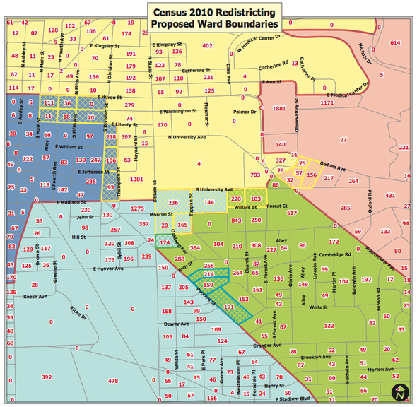
Ann Arbor City Clerk Jacqueline Beaudry is circulating this map showing proposed changes in the city's ward boundaries. The map is zoomed in on the downtown to show how the 1st Ward, in yellow, stands to lose several areas of the downtown and University of Michigan campus areas to other wards.
The changes, if approved by the Ann Arbor City Council, would put several 1st Ward residents who live in certain areas of the downtown and the University of Michigan campus in other wards. However, the overwhelming majority of city residents would not be affected.
The changes come following the 2010 census, which revealed population shifts throughout the city. While Ann Arbor's overall population dropped from 114,024 to 113,934, the 1st Ward — a pie-shaped area starting downtown and extending north — grew by 1,801 residents.
Beaudry has laid out a reapportionment plan with a targeted population of 22,787 for each of the five wards. To get there, the 1st Ward theoretically needs to lose about 1,800 residents, while each of the other four wards needs to gain about 450 residents on average.
"If we left the wards as they are now, Ward 1 would be much larger than the other wards and it would be about 8 percent deviation from the 22,787," Beaudry said.
The boundary changes would take effect prior to the Nov. 8 election. Beaudry said none of the council members or candidates running for council would be affected by the changes.
The city's five ward boundaries are drawn in such a way that they each assume a pie shape with the downtown being the center. Generally speaking, the 1st Ward represents the north side, the 2nd Ward represents the northeast side, the 3rd Ward represents the southeast side, the 4th Ward represents the southwest side and the 5th Ward represents the west side.
The map unveiled by Beaudry shows the 5th Ward expanding eastward into the downtown, taking over areas now in the 1st Ward. That includes the area bound by Main, Huron, Division and Liberty, and the area bound by Division, Thompson, Liberty and Madison.
The 4th Ward also would expand to take over parts of the U-M campus that are now in the 1st Ward, including the area bound by State, Hill, Tappan and South University, as well as the area bound by South University, East University, Monroe and Tappan.
Various other areas would change (download the full maps).
"They're very minor changes and we focus on the downtown because that's where the five wards meet," Beaudry said.
"With this the proposal, the smallest would be Ward 5, which is 66 people less than the target," she added. "And Ward 3 would be the most, which would be 132 people over the target. So the proposal is very close in terms of final numbers."
The city charter gives the City Council the authority to make the final determination on ward reapportionment. Beaudry said the changes will require two readings before council, which are expected to happen at the council's two meetings in July.
She noted that any precinct boundary changes could be approved by the Election Commission, which includes the clerk, city attorney and police chief. Affected voters would receive a new voter ID card in the mail prior to the election.
Beaudry shared the plan with council members Monday night. Council Member Sabra Briere, D-1st Ward, suggested an alternate plan that Beaudry said she'll consider.
"When I look at the boundary between the 1st Ward and the 5th Ward as proposed, I recognize that by moving a single block into the 5th Ward — instead of moving eight blocks into the 5th Ward — we'd have almost exactly the same numbers," Briere said. "It would be a simpler change all around, simpler for residents who live in those blocks because all of the gain to the 5th Ward, by my suggestion, comes from one address and that's Tower Plaza."
Beaudry plans to present the plan again during a panel discussion on the topic of redistricting being held by the League of Women Voters of the Ann Arbor Area. The forum is scheduled to take place from 7 p.m. to 8:30 p.m. Thursday at the downtown library.
Following the U.S. Census every 10 years, new lines are drawn for congressional and legislative districts, as well as county board districts and city council wards. Thursday's discussion is expected to offer a comprehensive look at the issues surrounding redistricting.
In addition to Beaudry, panelists include state Rep. Mark Ouimet, R-Scio Township; state Rep. Jeff Irwin, D-Ann Arbor; and Washtenaw County Clerk Larry Kestenbaum.
State House Republicans plan to release proposed new political maps for legislative and congressional districts Friday.
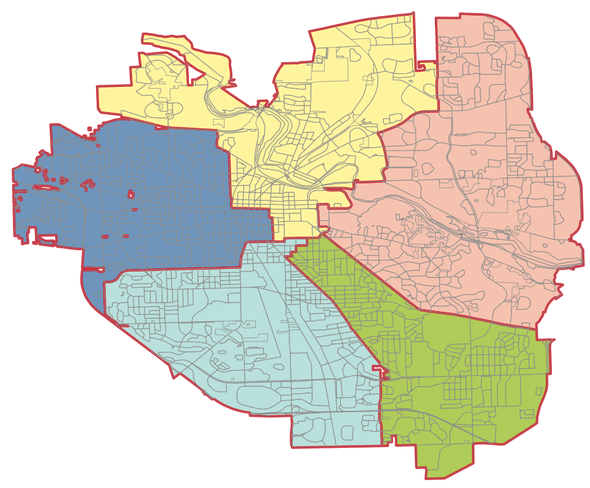
A look at the city of Ann Arbor's full ward map with the proposed changes.
Comments
newsboy
Wed, Jul 6, 2011 : 4:32 p.m.
How will this effect saving whales?
Roadman
Tue, Jun 14, 2011 : 8:34 p.m.
I have always felt that the Fourth Ward was rather unique of the Ann Arbor wards. The other four wards had their own specific and distinct type of ambience and "personality" with their own activist networks. The Fourth Ward however, the consensus of citzens say that it represents what is leftover from the other four wards. The Fourth Ward for decades had a reputation as the most conservative in Ann Arbor, inhabited by Bechtel engineers. The Landsdowne area to this day has a significant portion of its population as straight-ticket Republicans. It is the area where there is less direct group civic involvement by its residents, but one where citizens expect their tax monies to be expended wisely. A City Council candidate running for office could likely make great strides by going door-to-door in this ward.
dougfroma2
Tue, Jun 14, 2011 : 6:19 p.m.
What a pretty map! Want to guess which area (color) has the highest per capita income?
Andy
Wed, Jun 15, 2011 : 4:07 p.m.
2nd Ward (pink) absolutely no question.
John B.
Tue, Jun 14, 2011 : 7:13 p.m.
The Pink Zone?
John B.
Tue, Jun 14, 2011 : 7:12 p.m.
The Green Zone? What do I win?