
Argo Cascades still closed: Ann Arbor parks manager says Huron River might be at lowest level in a decade
The popular Argo Cascades feature on the Huron River remains closed due to low flow conditions, an Ann Arbor official said.
While some people are attempting to negotiate their way through the cascades on their own, a stop log remains in place at the entrance and the city isn't sending kayakers or tubers down from a livery operations perspective, said Colin Smith, the city's parks manager.
"On a related note, this is the lowest park staff remember the river being over the last 10 years," Smith said. "We have often had to limit or not allow river trips based on dangerous high water conditions, but this is the first time we have had to restrict river trips due to low water. Another example, I suppose, of extreme weather fluctuations."
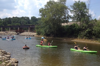
The Argo Cascades when it was open a few weeks ago.
Ryan J. Stanton | AnnArbor.com
At this point, the cascades remain closed from a livery operations perspective. While there is still flow through the cascades and some people with their own inner tubes are still using it, there is a stop-log inserted at the entrance that has diverted the amount of water entering the cascades. This has been in place since Thursday morning.
This has been brought on by the drought-like conditions we are experiencing that has resulted in extremely low flow rates in the river. In order for the city to comply with the Federal Energy Regulatory Commission and the MDEQ minimum flow requirements across Barton and Argo dams, the low flow in the river necessitates closing Argo Cascades. Staff will continue to monitor river flows and the flow will be restored to the cascades when flow in the river improves.
The lack of rain in the Huron River Watershed has resulted in unprecedented low flows that we have not seen since the 1980s. As operators of four dams on the Huron River, the city is required to pass what is called “run-of-river” by each of the dams. This means that whatever flow approaches each dam must be passed by the dam. The city is not permitted to store water behind any of its dams and release the water at its discretion for future use.
What does closing the cascades mean from a recreational standpoint? Given the extremely low flow currently in the river, it actually doesn't impact livery operations significantly at this time. As of two weekends ago, the river flow was already so low that we were only allowing single kayaks (less weight) down the river from Argo to Gallup — not because of the cascades, but because the river was so low at points downriver (Island Park, Riverside, the Arb) that people were getting stuck and having to get out and carry their boats to deeper water. We were planning on not allowing any river trips between Argo and Gallup this past weekend unless we received some rain that brought the river levels up significantly.
So, in short — cutting off some of the flow to the cascades until we get some much needed rain in order to comply with dam water passage requirements is not that impactful to us. On a related note, this is the lowest park staff remember the river being over the last 10 years. We have often had to limit or not allow river trips based on dangerous high water conditions, but this is the first time we have had to restrict river trips due to low water. Another example, I suppose, of extreme weather fluctuations.
The good news from a recreational standpoint is that numerous other paddling opportunities still exist while we wait for rain and river levels to rise. Pond paddles that remain in the impoundment areas (between Barton and Argo dams, and in Gallup Pond) are available and we will also be running trips from Delhi (upstream of Ann Arbor) to Argo for people wanting a longer trip. That particular trip is almost all through impoundments, so low water is not as much of an issue.
A kayaker posted this video of June 17 trip down Argo Cascades on YouTube:
Ryan J. Stanton covers government and politics for AnnArbor.com. Reach him at ryanstanton@annarbor.com or 734-623-2529. You also can follow him on Twitter or subscribe to AnnArbor.com's email newsletters.
Comments
Sabra C Briere
Wed, Aug 1, 2012 : 11:10 a.m.
I checked with Molly Wade (in charge of dams) and Colin Smith. Their response: "The City operates all of its dams as "run of river". Run of river operation is confirmed by maintaining specified pond levels. The dam gates are set at a minimum flow position and operate automatically from this set point. During extremely low flows, the normal minimum set point for the gates is too high; the result is more water flows over the gates than what is actually coming down the river. The pond will begin to drop in level and will continue to drop until the gates can manually be adjusted downward to match the river flow. On July 9, 2012, the City made an adjustment to the gates in an effort to accommodate the extremely low flows. During the period of July 9-25, the Barton Pond level began to drop but was still within allowable range. On July 26, 2012 Barton Pond level fell outside of allowable range. Argo Pond had also begun to react and lose pond level. The City responded by adjusting the gate at Barton further downward, allowing only what was flowing in the river to pass. The City also lowered the flow to the Cascades to allow more water over the gates of Argo dam. However, because the Barton gates were lowered to match the river flow, the overall flow through Argo concurrently dropped to match the river flow. The USGS stream gauge is reflective of conditions in the river; both the flow over the dam gates and through the Cascades is captured in this reading. Allen Creek also discharges just upstream of the gauge, so spikes during and immediately following a rain event are often a reflection of the discharge volume of the creek. Fluctuations in gauge readings do occur because of gate operations. These operations may be manual or automatic and occur to maintain pond levels, perform maintenance or to pass logs and other debris that are hindering flow through the gates."
ribs1
Wed, Aug 1, 2012 : 4:43 p.m.
Epenger, I spoke with the dam operator yesterday and he confirmed that they operate the dams based on lake levels in both Argo and Barton ponds.
Rork Kuick
Wed, Aug 1, 2012 : 4:17 p.m.
The biggest spike yesterday was with the help of Allen Creek, but there were some pretty big ones that weren't. Still, I apologize for not checking Allen's flow, and admit I was wrong.
Epengar
Wed, Aug 1, 2012 : 2:52 p.m.
Thanks Sabra! Rork, that type of sudden spike in flow seems reasonable given the thundershower early in the morning on the 31st. Typical urban flow -- rain falls and immediately runs off of pavement and roofs into the storm drains and then to the river. ribs1, the way I read the city's reply, they are only maintaining the level of Barton Pond. Since that's where the city's water intake is, that seems reasonable to me, and I bet there are special FERC/MDEQ rules for that. Also, it just occurred to me that for FERC/MDEQ purposes, "Argo Dam" might mean both the concrete structure, and the earthen dam that separates the Cascades (and formerly the channel feeding the hydroelectric plant) from the main channel of the river. If that's the case, then as long as the total of the flow going over the concrete dam + the flow through the Cascades is equal to run of the river, than the regulations might be satisfied. If that's right, then the quarter mile stretch of the channel between the concrete dam and the outlet of the Cascades could get cut off. I don't know if this is the case, I'm just speculating, but it would be something to find out.
ribs1
Wed, Aug 1, 2012 : 1:02 p.m.
Sabra, This is exactly the problem. Maintaining pond levels is exactly the opposite of maintaining run of the river conditions. These are NOT lake level control dams. The city is using Barton and Argo dams to maintain the lake levels in Barton and Argo ponds in direct violation of FERC and MDEQ regulations.
Rork Kuick
Wed, Aug 1, 2012 : 12:33 p.m.
Thankyou for the info. Yesterday, the river fluctuated between about 75 and about 240 cfs (and back again) within just a few hours. Call it run of the river if you like. Seems like horrible performance to me.
Rork Kuick
Tue, Jul 31, 2012 : 4:03 p.m.
Could a reporter please ask the dam managers what has been going on with the fluctuations below Argo? July 9-25 the flow seemed much more stable than usual, as if they had changed the way the dams operate. July 16 it dropped from about 120 to 60cfs for reasons I can't understand. (Where exactly is that gauge - does the bypass volume affect the water readings.) Still river was stable. Starting around July 28, we are back to the usual crazy fluctuations, which are bad. Sometimes those are due to a flashy Allen Creek, but I don't think that nearly explains them all (except 1). You see, it appears our dams are very sophisticated, that's why they work so poorly. Please hassle those dam operators and get some answers. I often wonder why Argo was designed the way it is - what is the advantage of these gates? I've never heard it explained. I do see the down side though.
Dog Guy
Wed, Aug 1, 2012 : 2:42 a.m.
Yes indeed, Rork Kuick, those dam fluctuations make it difficult to rollerskate the riverbed.
Epengar
Tue, Jul 31, 2012 : 7:03 p.m.
Rork, have you talked to the Watershed Council about this? It seems like an issue they could put a little pressure on.
Rork Kuick
Tue, Jul 31, 2012 : 4:33 p.m.
Maybe I have a low-probability theory: There was so little water over Barton dam, that they stopped putting any through the turbines, and maybe that lets the flows be more stable. Anybody know how to tell the power output of Barton on any given day?
DKL
Tue, Jul 31, 2012 : 4:20 p.m.
The Ann Arbor gauge is located just upstream of the Maiden Lane bridge
ribs1
Tue, Jul 31, 2012 : 4:12 p.m.
I have also noticed the wild fluctuations. http://waterdata.usgs.gov/mi/nwis/uv?site_no=04174500 Clearly there is something wrong with either Argo or Barton dam. BTW, the USGS gauging station is downstream of Argo dam about a mile located near the entrance of riverside park.
Ross
Tue, Jul 31, 2012 : 2:20 p.m.
Before attempting any kayaking trip through Ann Arbor, I always google "USGS Huron River" and the top result is the flow data for Ann Arbor. Anything under 200 CFS is not fun at all. 1000 CFS is a real blast, and 1500+ can start to get a little scary (for families, I still love it). Under 100 CFS, like we have now, = constant rock bashing, algae and plants on the surface, garbage poking up out of the water, stinky mud, and so on.
cgerben
Tue, Jul 31, 2012 : 2:15 p.m.
Very cool video. *This* is what an online newspaper can/should provide that print cannot.
ribs1
Tue, Jul 31, 2012 : 1 p.m.
Right now the gauge at Hamburg is reading 108 cfs. The gauge at Ann Arbor is reading 90 cfs. Upstream gauges should never read a higher flow rate than downstream gauges. Tell me these dams are operated as run of the river.
Rork Kuick
Tue, Jul 31, 2012 : 4:25 p.m.
"So far the city has not complied." For 30 years, I believe. I hope to live long enough to fight re-licensing. Plenty of ammo.
ribs1
Tue, Jul 31, 2012 : 2:30 p.m.
Ross, This is actually a really good argument which highlights one of the real problems. The license for Barton and Argo dams requires that the inflow into Barton pond is the same as the outflow over Argo dam. FERC has also mandated that streamflow gauges be installed just upstream from Barton Pond and immediately below Argo dam. So far the city has not complied. We can all look at the gauges at Hamburg and the Ann Arbor gauge and make speculations. We can also make educated guesses on flow rate by traveling to the sites (right now however its not really a guess. There is very clearly much more flow entering Barton Pond than exited over Argo Dam) But the real problem is that the City is unwilling to comply with run of the river regulations including installation of appropriate stream flow gauges.
Ross
Tue, Jul 31, 2012 : 2:21 p.m.
Ribs, good point. Thanks.
ribs1
Tue, Jul 31, 2012 : 2:20 p.m.
Ross, Not really because there as also 25cfs coming in from Mill Creek and many other flows coming in from smaller creeks between the Hamburg gauge and the Ann Arbor gauge.
ribs1
Tue, Jul 31, 2012 : 2:19 p.m.
Oldtimer, You are correct. However, evaporation does not count for run of the river conditions. FERC mandates that the inflow into the pond is the same as the outflow over the dam. In certain conditions (like we have now) this means that the pond levels should go down because of evaporation and other draws.
Ross
Tue, Jul 31, 2012 : 2:17 p.m.
I thought I had read previously that the average water withdrawal rate from Barton pond was about 18 CFS for drinking water for the city of Ann Arbor. Awfully coincidental with your current flow numbers, eh?
OLDTIMER3
Tue, Jul 31, 2012 : 1:46 p.m.
ribs1 you just said (above) that there is a lot of evaporation which would lower the flow rate. And is possible people are pumping water out illegally for irrigation purposes.
Arboriginal
Tue, Jul 31, 2012 : 12:44 p.m.
Hmmmm.....closed eh? Will somebody tell the Dirties that? It was flowing pretty good yesterday and many people were floating down and swimming in the pools.
tdw
Tue, Jul 31, 2012 : 10:55 a.m.
Now correct me if I'm wrong but it seems A2 has decided that the river is theirs and screw every one down stream.I'm no expert on rivers and haven't been down there ( Dixboro ) but it just seems that way by the videos
ribs1
Tue, Jul 31, 2012 : 12:07 p.m.
You are not wrong. The farther you go downstream from Ann Arbor the worse it is. Ann Arbor is withholding water in all of these ponds.
Tru2Blu76
Tue, Jul 31, 2012 : 6:49 a.m.
Eh, which is more dangerous and deserving of safety interventions-- high water on the river or low water on the river? Seems to me, it's high water that causes the most dangerous conditions. As for the justification used (low water forces people to carry their canoes to deeper water): that's called portaging and it's always been a natural part of canoeing. So may this blocking of the Cascades be another Nanny State interference? I tend to think it is.
Epengar
Tue, Jul 31, 2012 : 7:01 p.m.
There are other good reasons to be concerned about artificially low flow in the river. It's hard on the ecosystem. Aquatic plants and insects get killed off, and they the base of the food chain in the river supporting fish and birds. Also I'm not sure, but I bet that changing flow rates, from low to high and back again, increases erosion of silt and mud, which lowers water quality downstream and in Lake Erie. The middle and lower Huron are already in trouble for that.
SillyTree
Tue, Jul 31, 2012 : 10:40 a.m.
It may be that the cascades allow a flow rate higher than that of the river at this current time. It would be necessary to block that flow to prevent this higher flow rate.
Epengar
Tue, Jul 31, 2012 : 5:16 a.m.
How can you know about flow rates at the four dams, when there is only one flow gauge within the city?
Ross
Tue, Jul 31, 2012 : 2:15 p.m.
ribs, remember that the city of Ann Arbor also pulls drinking water form Barton pond. Right?
ribs1
Tue, Jul 31, 2012 : 12:06 p.m.
Because when the city reports to FERC, they report pond levels and not flow rates. They are operating the dams as lake level control dams and not run of the river dams (federally mandated). Also, the Huron River Watershed Council has equipment to measure inflow and outflow. In addition, using common sense you can drive up to tubbs road where Barton pond begins and see lots of flow, then go look below Argo dam and see almost no flow.
ribs1
Tue, Jul 31, 2012 : 4:30 a.m.
The stop log has had no effect on the flow through the cascades. Also, even though required, the city is not maintaining run of the river conditions at any of the dams. The levels in the huron below argo dam are down about 4 feet. The water levels in Argo and Barton ponds are not down at all. The city is clearly withholding water in the ponds. Please take a look at these 2 videos. I shot the first video prior to the installation of the so called "stop log" the second video was shot after the stop log was installed. This device has had no effect on flow and no effect on the amount of water diverted from the river. http://www.youtube.com/watch?v=6J7YkaLwHQ8 http://www.youtube.com/watch?v=eHDutE_rIf4 In addition, I believe the stop log creates a hazard at the mouth of the cascades.
ribs1
Tue, Jul 31, 2012 : 12:02 p.m.
Silly Tree, You hit the nail right on the head. The high surface are of these ponds results in a lot of evaporation. In addition to evaporation there is also seepage through the bottom back to the ground water. Ferc does not consider evaporation, seepage or anything else when they mandate run of the river conditions. The consider the inflow and outflow.
SillyTree
Tue, Jul 31, 2012 : 10:37 a.m.
If flow of river is maintained, the ponds will maintain their level. For a pond to gain water to rise to a higher level, water would have to be taken from the flow. For a pond to drop in level, water would have to be released from the pond in addition to the flow through the river. Of course, this does not take evaporation into account. The ponds do lose quite a bit of water due to evaporation, but that could be considered flow, albeit not in the traditional sense.