
Blast of winter cold and snow headed for Ann Arbor
Winter, the season that this year forgot, will make a brief appearance this weekend in the Ann Arbor area.
A little snow and a blast of bone-chilling cold will move in Friday. Cold temperatures will stick around for the weekend before moderating again next week.
A little snow and a blast of cold are on tap for Ann Arbor this weekend.
The winter blast comes on the heels of a report from the National Oceanic and Atmospheric Administration noting that January was the fourth warmest on record in the contiguous United States. In Ann Arbor, January was the 13th warmest on record.
Another sunny day is on tap for today with a high around 40. Winds gusting to 23 mph will likely temper our enjoyment of it though.
After an overnight low of about 25, the temperature will climb to about 37 Friday and snow will move in the afternoon, the National Weather Service says. The chance of snow is 80 percent, but less than an inch of accumulation is expected. Winds gusting to 24 mph will make it feel colder than it really is.
Serious cold moves in Friday night. The low will drop to about 11 degrees, and a north wind gusting to 28 mph will make it feel as cold as 3 below zero. There’s also a 40 percent chance of snow showers.
Saturday, expect a partly sunny day with a high near 23. Winds will continue to blow, gusting up to 28 mph. The temperature will drop to around 16 Saturday night.
Sunday will bring mostly sunny skies with a high of 27. After a low of 18 overnight, temperatures will climb back into the low 30s Monday under mostly sunny skies. More snow showers are possible Monday night.
For updated forecasts and weather conditions any time check AnnArbor.com's weather page.
Comments
Tru2Blu76
Thu, Feb 9, 2012 : 9:05 p.m.
While it's true that "isolated extremes" of weather are NOT indication of global CLIMATE warming -- It IS true that most of the U.S. "warmest years on record" have happened IN THE LAST 11 YEARS. Keep in mind, the calendar shows we're in the middle of winter. The Jet Stream starts to oscillate this time of year: it's normal to see cyclical warm / cold variations of a few days. But the Arctic has been abnormally warming for decades: so we're going to see warmer winters overall for the foreseeable future. Because of equatorial warming, the Jet Stream has been pushed to a pattern farther north. So we could expect warmer summers as well. Trying to replace scientific methods with ideological clap-trap is not exactly "good thinking."
garrisondyer
Thu, Feb 9, 2012 : 11:55 p.m.
Hear, hear, T2B76. As a science teacher, I can't stand all the knee-jerk reaction to specific temperature extremes, whether cold or warm. Climate change/global warming has to do with climate, not the current weather... It boggles my mind how so many can't get their minds around this.
fjord
Thu, Feb 9, 2012 : 8:46 p.m.
The link at the end of the article has a typo, so it yields a "Page Not Found" message. On the actual weather page, has anyone noticed that the "Seven Day Forecast" is really only a 3½-day forecast? Sure, it gives you seven separate forecast segments, but there are two segments devoted to each day, so you never get one for the full week. Not a difficult fix, folks.
Cindy Heflin
Thu, Feb 9, 2012 : 9:18 p.m.
That link has been fixed, and we're addressing the discrepancy between the title and the forecast on the weather page.
Belgium
Thu, Feb 9, 2012 : 5:55 p.m.
Where are all the talking heads who screamed about Global Climate Change being a myth last winter? The 4th warmest January in history? If you're going to conflate Climate with Weather, you should be consistent. Start screaming about our eventual fiery death! (I'm looking at you, Fox "News" Network).
zags
Thu, Feb 9, 2012 : 8:31 p.m.
Everyone knows our fiery death won't come until next December.
WalkingJoe
Thu, Feb 9, 2012 : 6:45 p.m.
Oookay...I guess this makes sense to somebody.
Dan Darbor
Thu, Feb 9, 2012 : 4:37 p.m.
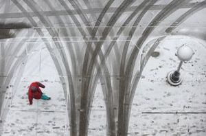
Looks like someone failed to give photographer Lon Horwedel credit! Photograph was first used January 11, 2011 by annarbor.com. "A pedestrian makes their way past the Washington Street parking garage entrance in downtown Ann Arbor, as heavy snow begins to pelt the area early Tuesday afternoon." Jan. 11, 2011 Lon Horwedel <a href="http://www.annarbor.com/news/drivers-slide-crash-on-freeways-as-winter-storm-moves-into-ann-arbor-area/">http://www.annarbor.com/news/drivers-slide-crash-on-freeways-as-winter-storm-moves-into-ann-arbor-area/</a>
smokeblwr
Thu, Feb 9, 2012 : 6:30 p.m.
What happened to Lon?
treetowncartel
Thu, Feb 9, 2012 : 5:10 p.m.
I miss Lon
ypsicat
Thu, Feb 9, 2012 : 3:59 p.m.
What are those swooping vertical lines in the photo?
ypsicat
Thu, Feb 9, 2012 : 5:52 p.m.
Far out!
a2miguy
Thu, Feb 9, 2012 : 5:04 p.m.
tire marks
Audion Man
Thu, Feb 9, 2012 : 3:02 p.m.
The fact that a blast of cold and snow is coming in February- in Ann Arbor, is news, is profoundly weird.
xmo
Thu, Feb 9, 2012 : 3:01 p.m.
Looks like a good time to idle your car and release all of that CO2 that we have been storing up so that we can get some Global Warming! If you believe?
MRunner73
Thu, Feb 9, 2012 : 2:26 p.m.
Oh well, this is Michigan, not Tennessee. We also haven't seen the last of the snow events, we normally see a couple inches fall in April.