
Cold temperatures expected to give way to 4-6 inches of snow in the Ann Arbor area
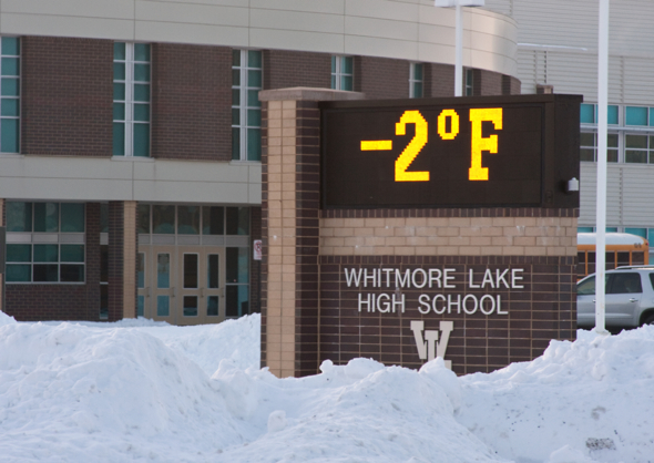
Temperatures plunged overnight, as seen this morning on the sign outside Whitmore Lake High School. Steve Pepple | AnnArbor.com
Don’t worry — it won't be this cold all day long.
But watch out, there’s another 4 to 6 inches of snow coming our way.
A high-pressure system from Canada combined with clear skies and fresh snow to drive temperatures in Ann Arbor and surrounding areas down below zero overnight, said National Weather Service meteorologist Dave Kook.
It was 4 below zero around 8:30 a.m. in downtown Ann Arbor.
Those temperatures are going to climb fast, Kook said. It’s likely to reach 30 this afternoon, with temps overnight in the 20s and a little bit of snow and rain mix. But no real accumulation is expected, Kook said.
That changes Thursday night into Friday morning, when a system working up from the south is expected to “clip” southeast Michigan and add 4 to 6 inches of fresh snow to the 9 inches already on the ground, Kook said.
Comments
Yeah buddy
Wed, Feb 23, 2011 : 8:41 p.m.
So based on past projections turning out to only be about 1/3 of what we actually saw, we should get (4*3-6*3) or 12-18 inches this time.
breadman
Wed, Feb 23, 2011 : 8:25 p.m.
Check out your calendar! Nothing is wrong with the ground hog!! Ground hog day Feb.2nd 2011! But spring arrives on March 20th 2011!! Shadow or no shadow, Punsutawney tells us we are half way through winter, and another six weeks before spring. Count it on your calendar. But I have seen snow flakes fall in May for mothers Day............
Dave66
Wed, Feb 23, 2011 : 6:43 p.m.
After years of transporting a shovel in my trunk every winter, I finally got to use it. I dug two students out of a snowbank on Maynard just south of William. Some advice for our two hapless heroes who have never driven in snow before: 1) If the snow is deeper than your axle, it's not a parking space any more, so keep looking. 2) Rock the car back and forth to build momentum, don't just sit there spinning the tires. 3) Don't turn the wheel. Back straight out, the way you came in. 4) If you are lucky enough to have a friend with you at the time, have him push instead of just standing there with his hands in his pockets looking stupid I hope this helps.
spm
Wed, Feb 23, 2011 : 10:20 p.m.
Good job! Gee, I wish you had been around yesterday morning. I got stuck in a parking lot that I had been able to get into but not out of. I had more than one person jog by me (on Huron River Drive) and not one stopped to help me. I finally thought to get my floor mats out and stick them under the tires and inched my way out. Now more snow is one the way? At least I've learned a lesson and have put a shovel in the car.
John B.
Wed, Feb 23, 2011 : 6:57 p.m.
Now *you* rock!
Harley B. Rider
Wed, Feb 23, 2011 : 6:31 p.m.
The best government is the least government. Local associations can get local things done quicker than county, city, or even township governmental units can. It's obvious what happens when one depends on city or county government to handle local issues - like subdivision roads.
clownfish
Thu, Feb 24, 2011 : 2:42 p.m.
So would you advocate a return to subscription fire departments? Remove the police depts and replace them with private security service for only those that can afford it? Would each person or association be responsible for clearing the main roads in front of their subdivision? Are you going to keep N. Territorial repaired in front of your private road, replacing it as necessary? BTW, I live on a private road too. Sometimes it gets repaired when I want, sometimes the other residents don't have the money. Sounds like the govt.
Edward R Murrow's Ghost
Wed, Feb 23, 2011 : 6:22 p.m.
@Harley wrote: "There are nice houses available in developments with private roads that are always plowed within a few hours, not a few days. We band together to handle those things WITHOUT depending on government." So a group of people ("We the People") have come together to pool their resources in order that certain services ("in order to . . . promote the General Welfare") are accomplished that benefit all of the people? Sounds like a government to me. Good Night and Good Luck
clownfish
Thu, Feb 24, 2011 : 2:46 p.m.
You are right BORN, unions suck. Why the very idea of people with similar goals coming together to advocate, having democratic elections to vote for representatives, voting on contracts ets is sooo anti-American. Better to have stockholders, that come together with a similar goal, hold democratic elections for leaders and vote on procedures.
bornblu
Wed, Feb 23, 2011 : 7:25 p.m.
Not a government; no unions to deal with!!
Dave66
Wed, Feb 23, 2011 : 6:35 p.m.
You rock.
Harley B. Rider
Wed, Feb 23, 2011 : 6:09 p.m.
lumberg48108 - come on out to "God's Country" (west of Zeeb Road). There are nice houses available in developments with private roads that are always plowed within a few hours, not a few days. We band together to handle those things WITHOUT depending on government.
clownfish
Thu, Feb 24, 2011 : 2:07 p.m.
Harley, did you not work for the govt for a couple of decades? IE, were you not part of the problem? How long is your street? I think about 2-300 feet? Did you get N. Territorial cleaned up? The govt could clean up all streets in a timely manner, given enough money. How much more are you willing to pay to get perfect results every time?
dee
Wed, Feb 23, 2011 : 8:08 p.m.
...and if you go a bit further west, you'll find kind neighbors happily getting their "toys" out--trucks, tractors, bobcats, and such. No government needed at all.
John B.
Wed, Feb 23, 2011 : 6:07 p.m.
Weather forecasts are like economic forecasts: get three forecasters together in one room, and you'll get four different forecasts, as the old saying goes.... It ain't easy, with all of those variables in play simultaneously....
lumberg48108
Wed, Feb 23, 2011 : 5:42 p.m.
Great - more snow and less snow removal than ever! I will plan NOW to be stuck in my drive since we dont prioritize subdivisions in this county ... From the Road Commission "... back to back winter storms ... create issues ... subdivisions might not be cleared for four days or more..." I wrote it yesterday - local governments exist to provide services! Waiting two days to get my subdivision plowed is simply not acceptable, nor should it be policy! If other communities can remove so, we have ZERO excuse as to why we cannot!
clownfish
Thu, Feb 24, 2011 : 2:02 p.m.
Your govt has been drowned in the bathtub, the successful result of a decade of reducing revenue to keep money in the pockets of investors so that they can increase employment. See how ell it is working?
Edward R Murrow's Ghost
Wed, Feb 23, 2011 : 6:18 p.m.
Maybe you hadn't noticed, but funding of the WCRC has dropped precipitously. Good Night and Good Luck
81wolverine
Wed, Feb 23, 2011 : 5:38 p.m.
Great. Hopefully, the winter will finally end when March gets here - who knows. A trip to Florida or the Caribbean is looking awfully attractive right now!
John B.
Wed, Feb 23, 2011 : 6:10 p.m.
In SE Michigan, we can't really (safely) say that Winter is behind us until about May! (Which is about a month after mowing season begins...).
Sarah
Wed, Feb 23, 2011 : 5:19 p.m.
I just want to know if the storm will continue its timeliness and manage to screw up the evening rush hour.
John B.
Wed, Feb 23, 2011 : 6:12 p.m.
It sounds more likely that Friday morning's commute will be messy.... ... and then perhaps Friday evening's too....
Harley B. Rider
Wed, Feb 23, 2011 : 5:19 p.m.
Weather forecasts have a 50% chance of being accurate 50% of the time.
sun runner
Wed, Feb 23, 2011 : 5:10 p.m.
It's winter in Michigan. I expect snow every day. Sometimes we get a dusting. Sometimes we get a lot. My shovel is always ready outside my back door. Otherwise, if I want to know what the weather is like, I look out the window or step outside to feel the air. Forecasts and predictions only go so far.
YpsiLivin
Wed, Feb 23, 2011 : 4:59 p.m.
David, If you're looking for precision, try the National Weather Service page. They're willing to go out on a limb and say 3-5 inches on Thursday night and another inch on Friday, although they do hedge a little bit with their liberal use of the word "possible." <a href="http://forecast.weather.gov/MapClick.php?map.x=159&map.y=207&site=dtx&zmx=1&zmy=1" rel='nofollow'>http://forecast.weather.gov/MapClick.php?map.x=159&map.y=207&site=dtx&zmx=1&zmy=1</a>
clownfish
Thu, Feb 24, 2011 : 2:09 p.m.
Are you suggesting that a govt funded site is more accurate than a private site? Heresy!
David Cahill
Wed, Feb 23, 2011 : 4:35 p.m.
Yes, Stephanie, I know that your weather page is supplied by the Weather Underground. My point was that your coverage ought to be consistent. It would have helped, for example, if there had been a link to your weather page in the article, with the article pointing out the differences in the forecasts.
David Briegel
Wed, Feb 23, 2011 : 4:25 p.m.
Stefanie, Better be careful. Isn't The Weather Underground a radical leftist group? You don't need a weatherman to know which way the wind blows!
John B.
Wed, Feb 23, 2011 : 6:14 p.m.
The snowfalls, they are a - changin'
Tom Teague
Wed, Feb 23, 2011 : 4:17 p.m.
Weather forecasting is starting to remind me of those statements Alan Greenspan used to give: Seemingly precise and vague at the same time. Weather Underground was posting "additional moderate accumulations possible," just a moment ago. For those of us who are de-sensitized to snow this season, 4-6 inches might seem moderate. FYI, I'm not overcome with Irrational Exuberance at the prospect of more snow.
Stefanie Murray
Wed, Feb 23, 2011 : 4:04 p.m.
@David, our weather page is supplied with information from Ann Arbor-based Weather Underground.
Murphy
Wed, Feb 23, 2011 : 4 p.m.
I saw on the Weather Channel this morning that Ann Arbor broke the record low of -5 with a low of -6 this morning. I guess they could be wrong too!
David Cahill
Wed, Feb 23, 2011 : 3:55 p.m.
AnnArbor.com's own weather page only mentions "moderate accumulations" Thursday night, not 4-6 inches. We all know that weather "forecasts" are largely guesses. Nonetheless, I would hope that AnnArbor.com would at least give us *consistent* guesses.
loves_fall
Wed, Feb 23, 2011 : 3:22 p.m.
Somewhere in Punxsutawney is a groundhog who needs to be fired.
Tom Teague
Wed, Feb 23, 2011 : 4:22 p.m.
Funny one, loves_fall! I would add that, on the range of scientific instruments, Groundhogs Suddenly Roused From Sleep (GSRFS) probably rank pretty low. I'm sure that Weather Derivatives don't rise and fall on Punxsutawney Phil's forecasts.