
Damaging winds equal to a weak tornado headed for Ann Arbor area
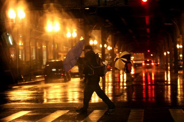
Pedestrians fight high winds and rain along East Madison Street and southbound Wabash Avenue in Chicago's Loop this morning. Strong wind and torrential rain buffeted the Midwest Tuesday as forecasters predicted the giant storm could be the most powerful to hit the Great Lakes area in more than seven decades.
AP photo
Editor's note: This story has been updated with information about a tornado watch issued for the area.
Hold on to your hat today and anything else that’s not tied down. A cyclone is headed our way.
Wind gusts of 60 mph could hit the Ann Arbor area about 12:30 p.m., said meteorologist Matt Mosteiko of the National Weather Service in White Lake, and a tornado watch was issued for Washtenaw County and much of lower Michigan until 6 p.m. today. Winds of 60 mph are equivalent to a weak tornado and strong enough to down limbs and trees and cause power outages, Mosteiko said.
The Chicago Tribune reported the storm could be the biggest in decades. The Detroit Free Press this morning reported it could be bigger than the one that downed the freighter Edmund Fitzgerald in 1975.
The National Weather Service has issued a high wind warning until 9 p.m. this evening. The period of highest winds is likely to last for a couple of hours today from 12:30 to 2:30 p.m., but sustained winds of 30-40 mph will continue throughout the day. A high wind watch is in effect for Wednesday, when winds of 25-30 mph will redevelop, and gusts of 60 mph are possible again. The period of highest winds Wednesday will last from four to eight hours, Mosteiko said.
Widespread showers with numerous thunderstorms will also develop today, and some storms may be severe. It will be warm, with highs of 68 to 72.
DTE Energy crews will be ready for whatever the storm brings, spokeswoman Eileen Dixon said. “We do have an in-depth storm emergency plan that we put in place when a storm is on its way," she said.
Crews are on alert and will be ready to tackle outages as they occur. DTE will also have employees assigned to guard downed lines if necessary for public safety, she said.
Ann Arbor Public Schools spokeswoman Liz Margolis said the district has canceled all outdoor recess today, and schools won't be holding gym classes outside. The district will monitor the weather throughout the day before deciding whether to cancel any after-school activities.
In Ypsilanti, Growing Hope canceled today's Downtown Ypsilanti Farmers Market, scheduled to be from 2-6 pm on Ferris and Hamilton streets in downtown Ypsilanti.
National Weather Service meteorologist Jim Allsopp told the Tribune the storm will be the most powerful to hit the Chicago area in more than 70 years. Tornado touchdowns and wind damage were reported in the Chicago area and flights were halted at O’Hare International Airport.
The winds are being generated by an unusually powerful jet steam east of the Rockies that’s fueling a very strong low-pressure system and cold front, Mosteiko said. The jet stream usually flows somewhere between 75 to 125 knots, but this is a 175 knot jet stream, he said.
“When there’s low pressure, things that are normally high up in the atmosphere are coming lower down," Mosteiko said. “Winds that are normally at 10,000 feet are coming down to the surface, and winds that are usually at 20,000 feet are at 10,000 feet.”
Mosteiko said any low pressure system storm can be called a cyclone. The storm will affect the entire Great Lakes Area and the Ohio Valley, he said.
Comments
Macabre Sunset
Tue, Oct 26, 2010 : 5:33 p.m.
Weakest tornado ever. There aren't even broken branches on my lawn. I was prepared to ride my house like Dorothy in Kansas based on all the warnings. I do think the "weak tornado" was strong enough to knock over a garbage can, though. But only the 80-gallon cans. Mercifully, the larger cans held up to the blast, preventing the governor from declaring this a disaster area.
Forever27
Tue, Oct 26, 2010 : 1:25 p.m.
Ann Arbor usually dodges the worst of the storms coming through the region. The Huron River Valley has everything to do with that.
Chris
Tue, Oct 26, 2010 : 1:20 p.m.
This storm wasn't a bunch of hype that resulted in nothing. Ann Arbor was fortunate the more severe weather skirted north and south of the city.
Emily
Tue, Oct 26, 2010 : 1:12 p.m.
Once again, a whole lot of hype for a lot of nothing. At least in Ann Arbor. And I fall for it every time. If there hadn't been such hype about all this today I would've just maybe *noticed* that it rained instead of waiting for some monster storm that never materialized.
ummsw
Tue, Oct 26, 2010 : 11:46 a.m.
Even though Ann Arbor isn't currently taking a direct hit, there are other areas that are in the direct path. I appreciate how well WXYZ pin points specific areas..They do a great job.
Urban Sombrero
Tue, Oct 26, 2010 : 11:28 a.m.
So far it's been a whole lot of nothing. I keep watching the radar, but even that looks......not so bad. Hype, hype and more hype. If we actually get a real storm, with real damaging winds......I'll eat my shorts. If I were as inaccurate at my job as these meteorologists are on a regular basis, I'd have been fired years ago.
Russ Miller
Tue, Oct 26, 2010 : 11:20 a.m.
@ robyn The Washtenaw County Skywarn system is running with lots of observers checking in. It's pretty unlikely to go down because the EOC has backup power and an alternate radio repeater available, and most of the observers have backup power of mobile radios, etc. Lots of redundancy... The Radioreference internet stream is offline, but that doesn't affect the EOC or observers at all. http://www.radioreference.com/apps/audio/?feedId=5230
treetowncartel
Tue, Oct 26, 2010 : 11:16 a.m.
Just great, now I have that dang song in my head.
5c0++ H4d13y
Tue, Oct 26, 2010 : 10:52 a.m.
Can't be a very good warning system if it can do down without the user knowing. I guess I should have left my motorcycle at home today. It should make my ride home interesting.
dading dont delete me bro
Tue, Oct 26, 2010 : 10:46 a.m.
didn't know skywarn was down. i get my watch/warnings through it.
robyn
Tue, Oct 26, 2010 : 10:36 a.m.
Is the SkyWarn network back up? I know they were downbut they said they were working on getting back online.
Top Cat
Tue, Oct 26, 2010 : 10:28 a.m.
We had a mini-tornado come through in June which snapped poplar trees that were so wide you couldn't put your arms around them. Let me tell you, it really does sounds like a freight train.
dading dont delete me bro
Tue, Oct 26, 2010 : 10:17 a.m.
tornadao WATCH has been issued by washtenaw county emergency operations center.
robyn
Tue, Oct 26, 2010 : 10:13 a.m.
I've been watching the Weather Channel - this certainly is a very 'interesting' weather pattern... Stay safe people and take cover if you think you need to. There have been tornados coming through with this front. Don't rely on just the sirens or the news - rely on your own instincts and common sense.