
Developments, road planning likely contributors to Millers Creek flooding
A team of environmental scientists hired by the city of Ann Arbor gathered Monday evening to present details of a study under way on Geddes Road flooding from Millers Creek on the east side of town.
Though no residents showed up for the meeting, those present were confident the project would likely garner public interest in the future should the study recommend solutions that affect residential properties.
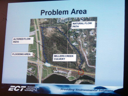
A slide from a presentation Monday night shows how Millers Creek diverts itself from its normal path at Ruthven Nature Preserve.
Huron Parkway was built directly in the middle of the creek’s path, so a large portion of the creek bed was diverted into a straight ditch on the east side of the road between Plymouth and Geddes roads when the parkway was built.
The Ann Arbor City Council hired an environmental consulting firm to study the waterway and provide a series of recommendations for solutions. The data collection from the field has been completed, Boote said. About 60 percent of the data analysis is done and a model of the creek is about 70 percent complete.
Ric Lawson, watershed planner for the Huron River Watershed Council who attended the meeting Monday, said Miller’s Creek is the most-studied waterway in the area because of its small nature yet steep slope. Data collected previously by the council is being used in the current study.
Ann Arbor City Councilwoman Jane Lumm, whose ward contains the section of Millers Creek in question, was present at the meeting Monday.
Lumm asked the scientists if construction at the former Pfizer site - now University of Michigan’s North Campus Research Complex - could have affected the creek’s flooding issues.
Boote said years of previous developments in the creek’s 2.4-square-mile watershed were likely to blame for the flooding, and that the NCRC was not a direct cause.
Though the meeting was not well-attended, Lumm and Jerry Hancock, stormwater and floodplain program coordinator for the city, said it was because the flooding currently does not affect anyone’s property - just the city park and Geddes Road.
Recommendations from the study could affect some residential areas in the creek’s watershed. Lumm said she remembered how strong public opinions were during the recent restoration project to Malletts Creek, and wanted to make sure that neighborhood organizations were notified of meetings in the future.
Miller’s Creek is the smallest tributary to the Huron River and flows south from Plymouth Road along Huron Parkway and around Huron High School before discharging into Geddes Pond and the Huron River at Ruthven Nature Preserve.
Years of sediment washed down the steep slope of the creek bed from upstream has deposited where the current slows to bend around the north side of Ruthven, adding up to three feet of soil in to the creek bed in some spots - an ongoing problem since the 1960s.
Water flowing down the creek has now found a path of lesser resistance. Instead of following its original route around Ruthven and underneath Geddes Road in a culvert more than 60-inches wide, the creek flows along Huron Parkway and forces itself through a 24-inch-wide culvert underneath Geddes Road to get to the river.
The smaller culvert, filled slightly with sediment, is no match for the flash flood-like conditions that occur during rain events. It doesn’t take much for Geddes Road to flood over for half-hour periods of time.
In the meantime, some work will be completed on the creek to remove some of the sediment built up on the north side of Ruthven.
The county’s Natural Areas Preservation Program has a Michigan Department of Environmental Quality permit to dredge about 457 cubic yards of sediment from the creek on the north side of the Ruthven preserve, which Hancock said will happen within the coming weeks.
Amy Biolchini covers Washtenaw County, health and environmental issues for AnnArbor.com. Reach her at (734) 623-2552, amybiolchini@annarbor.com or on Twitter.
Comments
Kai Petainen
Thu, Sep 13, 2012 : 5:07 a.m.
I need to start paying a bit more attention to this topic....
gretta1
Wed, Sep 12, 2012 : 1:10 p.m.
There is a stormwater retention pond just south of Bluett where Bluett intersects with Antietam. It is located in the Thurston Nature Center. This pond is mostly owned by AAPS with one small part owned by Orchard Hills Athletic Club. It is now so shallow it is more like a marshland. In the past couple of years, the city diverted more water to the pond; yet no one is responsible for maintaining the pond. Will this pond actually be able to serve its function as a stormwater retention pond if the level of silt reaches shore levels? At present, there aren't really too many homes that would be impacted by flooding but as one who lives in the area and regularly walks around the pond, I predict there will be increased flooding in heavy wet periods. Where the water flows I am not sure. If it can continue to be controlled so it does not contribute to the flooding downstream in Millers Creek, I guess it will not be a contributor to the current problems. However, from my perspective, it appears we are all saddled with an imperfect tool as far as a stormwater retention pond is concerned. By the way, it cannot be dredged by DEQ because that is considered a maintenance activity and thus will not be performed. The Thurston Nature Center Committee is slowly trying to raise funds for this to be done someday but the sum required is great at $100,000.00 minimum. Then there are the permits. So this citizen has to wonder why a stormwater retention pond was established to help the Millers Creek watershed if it is not going to be maintained by any parties? Yes, this is kvetching from a Thurston Nature Center local but I can't read articles about the Millers Creek flood problems down near Geddes without commenting on some of the unattended mess upstream.
PineyWoodsGuy
Wed, Sep 12, 2012 : 3:50 a.m.
Miller's Creek is a Gem of the First Water (Google "Wiki First Water"). I applaud all those that Love this Creek! Let's keep it flowing with clear, clean water!
Dog Guy
Tue, Sep 11, 2012 : 8:53 p.m.
I missed the amount we paid ECT for this study.
dotdash
Wed, Sep 12, 2012 : 1:37 p.m.
Well worth it. After Geddes was repaved a year ago, it has washed out at least twice by my count.
Amy Biolchini
Tue, Sep 11, 2012 : 9:03 p.m.
The Ann Arbor City Council approved $46,026 for the contract with ECT.
Katherine Griswold
Tue, Sep 11, 2012 : 7:20 p.m.
I hope the City addresses the dangerous erosion of Geddes Road between Hickory and the pedestrian entrance to Gallup Park. The shoulder of Geddes Road is all but gone leaving a steep drop of 30 feet. This area is in the Huron River watershed and just to the south of the Miller's Creek watershed. Yesterday there was a large pond at the bottom of the drop between the road and the railroad tracks. I was there taking photos, which I submitted to the City with a request to improve conditions for cyclist (as well as drivers). There is a gap in the bike path and dense vegetation to the edge of the road conceals most of the where the shoulder washed away. The City's response in previous years has been to pour asphalt down the drop -- think Slip-&-Slide. Photos are posted at seekids.org.