
Major changes to North Main-Huron River corridor recommended in final task force report
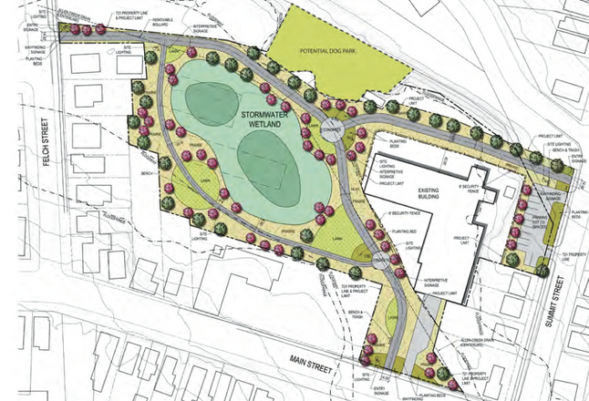
A conceptual site plan for a former city maintenance yard at 721 N. Main St., behind the Ann Arbor Community Center, includes a dog park in addition to trails and open space. A city task force recommends demolishing the buildings on the right side of the drawing and considering redevelopment options.
City of Ann Arbor
Those ideas and more are recommended in a new 28-page report — with a 50-page appendix — from the city's North Main-Huron River Corridor Vision Task Force.
The citizen-led group spent more than a year studying ways to improve one of Ann Arbor's major gateway corridors and released its final recommendations this week.
Sabra Briere, the lone City Council member on the task force, announced the release of the report at Tuesday night's council meeting.
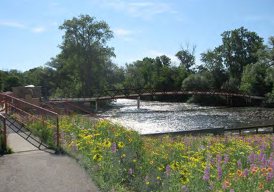
The report includes this image of what a pedestrian bridge could look like over the Huron River to connect the Argo Cascades area to the MichCon site.
City of Ann Arbor
The task force has developed a vision to improve conditions for pedestrians and bicyclists, increase public access to riverside amenities and address traffic congestion.
The report also recommends uses for the city-owned property at 721 N. Main St. and the riverside MichCon site that is owned by DTE Energy.
The task force previously recommended developing the flood-prone portion of 721 N. Main as a greenway park with a series of trails and open spaces, including a stormwater wetland area. The new report also shows a potential dog park mapped out on the site.
"A dog park was cited by many nearby residents as a desirable and relatively inexpensive active use option and coincides with the Park Advisory Commission's current search for a near-downtown location for one," the report states.
On the non-floodway portion of the site, the report states that two connected structures totaling more than 25,000 square feet have some rehabilitation potential, and both for-profit and nonprofit groups expressed interest in reusing them. But the task force grappled with the projected $6 million rehabilitation cost and instead recommends spending $300,000 to demolish them.
"Demolish the two buildings as soon as possible and clear and grade the site to avoid undesirable activities and eliminate the potential liability presented by these two vacant and unsound structures," the report states, further recommending the city should seek out potential developers.
If any type of vertical development occurs there, the report states, it should remain consistent with the residential scale and character of the neighborhood. The task force recommends the city be open to both public and private uses, including commercial and residential uses.
The hilly and hidden nature of the property weighed against the task force's consideration of recommending the entire property become open space.
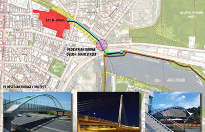
Another image in the report shows a pedestrian bridge going over Main Street and the railroad tracks, linking the 721 N. Main site and the Border-to-Border Trail at Argo Pond.
City of Ann Arbor
The report suggests city staff should devise a robust process for public input and engagement regarding all potential site amenities.
"Public recreational elements should focus on creating a unique place along the Huron River, increasing access to water-based recreation and enhancing connectivity to the Border-to-Border Trail, the Allen Creek Greenway and downtown," the report states, recommending public and private funding should be sought.
The report recommends a pedestrian bridge over the Huron River to connect the Argo Cascades area to the MichCon site.
The report also recommends constructing a tunnel to allow pedestrians and stormwater to pass under the railroad tracks from Depot Street — between Fourth Avenue and Main Street — to the MichCon site. That would provide a direct link from downtown to the riverfront.
Another image in the report shows a pedestrian bridge going over Main Street and the railroad tracks, linking the 721 N. Main site and the Border-to-Border Trail at Argo Pond.
The task force recommends widening and enhancing the trail along the river — including the narrow crossing over the Argo Dam — to lessen traffic conflicts.
The task force also wants the city to use wayfinding signs to "identify, embellish and encourage existing connections and views" between parks and pathways in the area.
The report recommends the city work with the Michigan Department of Transportation to find ways to reduce vehicle speeds on North Main and that a comprehensive mobility study be conducted to better understand various options for improving experiences for all users of the corridor.
The report shows an image of what a signalized pedestrian crossing could look like on North Main at Lake Shore Drive, providing a link between Bluffs Park and Bandemer Park.
The task force also recommends installing crosswalks across Depot Street at Fourth Avenue and across North Main at Depot Street.
Ryan J. Stanton covers government and politics for AnnArbor.com. Reach him at ryanstanton@annarbor.com or 734-623-2529. You also can follow him on Twitter or subscribe to AnnArbor.com's email newsletters.
Comments
Jon Wax
Fri, Sep 6, 2013 : 5:04 p.m.
Take the speed limit back down to 35 and you guys can do whatever you want with the rest of it. Whoever raised the speed limit up to 45... i have some pretty special names to call you that they won't allow me to print here. Peace Wax
Ryan J. Stanton
Thu, Sep 5, 2013 : 5:51 p.m.
The task force recommends that a multimodal mobility study of the North Main corridor look at all modes of transportation, motorized and nonmotorized, and that any redesign of the corridor should integrate the elements of Complete Streets with vehicle speeds no greater than 30 mph. At a minimum, the report states, these elements should be considered in the study: -- Extend bus transit to the north end of N. Main -- Left turn lane and/or reversible lanes -- Bike lanes -- Widen the sidewalk to a bike/pedestrian pathway width (10 feet) -- Landscape to protect sidewalks -- Improve signaling for vehicles and pedestrians -- Install sidewalks on the west side of Main -- Create a signaled pedestrian crossing of N. Main between Lake Shore Drive and the entrance to Bluffs Nature Area
thinker
Thu, Sep 5, 2013 : 4:58 p.m.
Where does this put the previous brainstorm to change North Main to three lanes, instead of 4, to add in bike lanes? How does this help traffic congestion?
Ryan J. Stanton
Thu, Sep 5, 2013 : 5:43 p.m.
From the report: "The Task Force has struggled with the conflict that exists between improving vehicular flow on N. Main and increasing safe bicycle and pedestrian access through the area and to the riverside amenities. Overlapping modes of travel and a wide variety of private property uses along this stretch of N. Main that sits adjacent to the railroad and riverside amenities have created a growing number of serious conflicts. While most motorized traffic is traveling through the corridor to access other parts of the City, the Task Force believes that their experience at this gateway could and should much better represent Ann Arbor."
Ryan J. Stanton
Thu, Sep 5, 2013 : 5:42 p.m.
I didn't notice anything in the report calling for a road diet/lane reduction. That would be the state's decision to make. The report recommends the city work with the Michigan Department of Transportation to find ways to reduce vehicle speeds on North Main and that a comprehensive mobility study be conducted to better understand various options for improving experiences for all users of the corridor.
B. Jean
Thu, Sep 5, 2013 : 3:52 p.m.
Like the bridge ideas. Excellent way to protect pedestrians and motorists.
Mike
Thu, Sep 5, 2013 : 2:48 p.m.
Now that all of the roads and other infrastructure is in good shape, let's build a park...............
Karen
Thu, Sep 5, 2013 : 1:53 p.m.
How was this task force selected? Are these all friends of the Mayor and the legacy city council members who have been ramming through various expensive and poorly supported projects such as "art", the "greenspace", "bicycle lanes", "roundabouts", ....and "downtown dog parks". Funny how a dog park has appeared in this proposal after a bogus "poll" reported last week, which appears to have been primarily conducted on dog owners, indicated "strong approval" for a downtown dog park.
DJBudSonic
Sun, Sep 8, 2013 : 2:50 a.m.
Brad your guess is pretty accurate, ask anyone who tried to apply for a 'neighborhood position' they were all filled before this task force selection process was made public.
ordmad
Thu, Sep 5, 2013 : 3:32 p.m.
That your problem. You guess. Think first and maybe do a little research.
Brad
Thu, Sep 5, 2013 : 2:53 p.m.
Three commission members, two councilmembers (one recently retired), two heavyweight business guys from DTE and First Martin, Ray Detter. And I'm guessing the "neighborhood representatives" are from the group of usual suspects as well. Regular Joes? I think not.
ordmad
Thu, Sep 5, 2013 : 2:41 p.m.
I count 9 out of the 14 that have no City position, volunteer or otherwise. Then there are three representatives from 3 City commissions (all unpaid) that one would of course want on a taskforce doing what this one did. And, of course, two members of City Council. How again is this a group of insiders?
Brad
Thu, Sep 5, 2013 : 2:17 p.m.
"Many" of the members are "regular Joes"? Bonnie Bona Planning Commission Connie Brown Ann Arbor Public Art Commission Cynthia Ives Boating/Fishing/River Users Darren McKinnon Water Hill Neighborhood David Santacroce North Central Neighborhood Elizabeth Riggs Huron River Watershed Council Julie Grand Parks Advisory Commission Mike Martin Business and Property Owners Paul Ganz Business and Property Owners Ray Detter Old Fourth Ward Rita Combest Huron River/Newport Sabre Briere Councilmember Sandi Smith Ward One Tamara Burns Broadway/Pontiac Neighborhood
ordmad
Thu, Sep 5, 2013 : 2:13 p.m.
I followed this Taskforce pretty closely. It had it quirks, but it was by no means a group of insiders. Had you had read the report, you'd know that many of the members were just regular Joes from surrounding neighborhoods and businesses. And the discussion of the dog park on that site started last November. Nice conspiracy theories though -- you should write a novel.
SonnyDog09
Thu, Sep 5, 2013 : 1:50 p.m.
So, how much does this vision cost and where will we get the money to pay for it?
Jon Wax
Fri, Sep 6, 2013 : 5:07 p.m.
U of M is going to pay for it, right? After all... it leads right up to the front door of the big house, yeah? let them cover the cost. Peace Wax
Dog Guy
Fri, Sep 6, 2013 : 4:02 a.m.
Those city dollars are mine; those county dollars are mine; those state dollars are mine; those federal dollars are mine. Such projects make me happy that I also am fully tax funded.
Ryan J. Stanton
Thu, Sep 5, 2013 : 5:39 p.m.
Those are future discussions to be had. Theoretically a lot of these ideas could be funded with mix of city, county, state and maybe even federal dollars.
foobar417
Thu, Sep 5, 2013 : 2:20 p.m.
Presumably the bulk of the funds would come from the county (which has a dedicated millage to support parkland development) or Michigan Natural Resource grants. The latter source of funds comes from the sale of mineral rights by the state, as guaranteed in the state constitution.
Bridget
Thu, Sep 5, 2013 : 1:32 p.m.
Because dogs are only second to geese & ducks in supplying E-Coli bacteria to waterways, any dog parks must be situated away from floodplains, and not in run-off paths.
Brad
Thu, Sep 5, 2013 : 1:48 p.m.
How about the compromise of people getting in the car and going to one of the existing dog parks?
foobar417
Thu, Sep 5, 2013 : 1:42 p.m.
It will not be possible to find a place to put a dog park with the following criteria: 1) Nowhere near any houses or schools or churches. 2) Nowhere near any watershed. 3) Conveniently located within walking distance of lots of dog owners. The real criteria that most people who want a dog park have: 2 blocks (not 1 block and not 3 blocks or more) from where lives, so he/she can't hear the barking but can walk there easily. There are going to have to be some compromises in order to create a dog park.
Silly Sally
Thu, Sep 5, 2013 : 1:29 p.m.
This was not a very well publicized citizens task force. The mayor most likely hand picked members so no one would object to the part that recommends that the DTE lot be turned into a park, dove-tailing with his plans to move the railroad station 1/2 mile onto virgin parkland. Why spend hundreds of thousands to clean up polluted land that is under paved over parking lot that is needed for parking for a crowded railroad station and then cut down trees next to a river and pave the land to build another lot, all at a high taxpayer cost? This could be a win-win, as the Amtrak station needs more parking and the Argo canoe needs more parking. A simple bridge could fix this. This is amazing, a paved lot, next to a station that needs a lot, and this mayor wants to tear it up and turn it into a park and then build a new lot onto park and elsewhere. Only in Ann Arbor. Are our taxes not high enough?
Ryan J. Stanton
Thu, Sep 5, 2013 : 5:37 p.m.
From the final report: "Pursuant to its charge, over the course of thirteen months, the Task Force held nineteen regularly scheduled public meetings, numerous public subcommittee meetings and four well attended community meetings. Public input and participation extended beyond these meetings to A2 Open City Hall online civic engagement forums tied to the community meetings. At nearly every Task Force meeting, area stakeholders, City staff and/ or other interested parties spoke on various issues. The Task Force also considered the 1988 and 1993 City of Ann Arbor studies of the area."
Ryan J. Stanton
Thu, Sep 5, 2013 : 5:36 p.m.
This was a pretty well-publicized public process. I got a lot of alerts and notices the city sent out, which allowed me to write several stories about the meetings that were happening and the ideas that were being discussed. There also were two websites for the task force at a2gov.org/northmain and renewnorthmain.org that listed a lot of information, including links to documents and notices of meetings.
foobar417
Thu, Sep 5, 2013 : 2:17 p.m.
The remediation by the river was done by DTE at DTE expense to comply with state requirements. The city had nothing to do with it. http://www.annarbor.com/news/dte-energy-calls-michcon-cleanup-success/ As for the livery, I pointed that out as the only overlap between this report and the DTE site. However, that has nothing to do with the bulk of the DTE land near the train tracks which could be used for parking, a new station, whatever DTE wants to sell it for, or parkland.
Silly Sally
Thu, Sep 5, 2013 : 1:56 p.m.
The pavement at one time was very close to the river. Much of it has recently been torn up already. Oh, so silly. Wrecking a needed lot next to a station. The pavement did a good job of keeping the pollution in check, I wonder how much now is on the bottom of the Huron River, in the top of the sediment? I'm not eating any fish caught from this river now. The article states, "dialogue with DTE officials about the potential use of the site for a riverside park with a new canoe livery to complement operations at the Argo Canoe Livery directly across the river.
foobar417
Thu, Sep 5, 2013 : 1:38 p.m.
This was a very well publicized task force commissioned by the entire council with a specific list of tasks to tackle. Both papers wrote up many articles about it. They have a dedicated web page, plus a page on the city website. They had many outreach meetings. To say otherwise is to ignore the facts. The report has nothing to do with the train station. The only bit that is tangentially related is the desire to have the B2B trail extend along the south bank of the river and maybe have a second canoe livery there, but that has nothing to do with what they do with the part of the property near the tracks (where the pavement is) or where station-related changes could be made.
Brad
Thu, Sep 5, 2013 : 1:27 p.m.
Are there any concerns with having a dog park in the worst part of the flood plain? Looks like the runoff would go right into the "stormwater wetlands". It also looks like the dog park would be on the other side of the RR tracks. Not to mention that there are businesses and homes in the immediate vicinity.
Carolyn
Thu, Sep 5, 2013 : 1:23 p.m.
The site needs to have good visibility in order to attract visitors. The North Main area does not feel safe to most people. The dog park is an afterthought and does not really provide a site within walking distance to central Ann Arbor residences, but I guess it is better than nothing. Come on out to Pinckney! We have a FREE dog park behind ARISE CHURCH on Dexter-Pinckney Road that is holding the PINCKNEY DOG FEST on September 14, thanks to the generous and compassionate work of the pastor's family (unlike A2 city park planners and Park Commission).
Jon Wax
Fri, Sep 6, 2013 : 5:05 p.m.
Which part of N main do you mean... "does not feel safe"? We have had no problems, bar some moron spray painting stuff randomly, but that usually gets cleared up pretty fast. Peace Wax
Arboriginal
Fri, Sep 6, 2013 : 1:01 a.m.
Pinckney. That's near Hell, right?
foobar417
Thu, Sep 5, 2013 : 12:09 p.m.
Overall the report has a lot of good ideas. It's good to have these stated as goals for the city as MDOT makes changes to North Main and the railroad in the coming years. Not mentioned in this article, but I liked the recommendations about changing the zoning along North Main. From the report, it looks like the linchpin to solve the traffic problems along North Main is widening the abutments that support the railroad bridge. Hopefully WatCo will be a partner and not an obstacle. There is another possible solution to the traffic congestion, which would be to add an entrance on to M14 from Pontiac Trail and maybe shut down the Barton Drive exit. Then some of the exiting hospital traffic could head north up Maiden Lane to Pontiac Trail to M14 (or vica versa in the morning). All of the proposed non-motorized improvements would be great. Hopefully they'll start working on grant funding for one of them and not waste time deciding which one to do first.
DJBudSonic
Sun, Sep 8, 2013 : 2:46 a.m.
You realize that Pontiac Trail is a 25 mph residential neighborhood street that passes a School and Community center, right? Why should it be an on-ramp for the highway? Pontiac Trail already has the hospital traffic headed for M-14, and it will only increase when the parking structure on Wall Street is done. The Broadway/Wall/Maiden Lane intersection is a virtual parking from 4-6 everyday already. How does shunting traffic from Main to here help anybody?
nicedoggy
Thu, Sep 5, 2013 : 11:32 a.m.
Pedestrian bridge is a great idea ! No more crosswalks that endanger all.
thinker
Thu, Sep 5, 2013 : 4:54 p.m.
What I have never figured out is how "pedestrian" bridges help the most vulnerable of pedestrians:those in wheelchairs. They are fair game to be hit by cars because they are below the level of sight when driving in a car.
B2Pilot
Thu, Sep 5, 2013 : 10:23 a.m.
Nice to see this area is getting the attention it deserves it is a major gateway and looks like well, an industrial park. One way to reduce speeds on main st. would be to reduce the speed lime. Past Depot it is 45, which translates to 50+ for most racing to the highway or off the highway. I still think some work needs to be done to divert the hospital traffic, maybe a commuter lot with a bus station somewhere along that stretch. Anything will be
B2Pilot
Thu, Sep 5, 2013 : 10:26 a.m.
Must still waking up I hit the send key before proofing, should read; reduce speed limit > not speed lime. my final sentence should read Anything will be an improvement.