
Weather service map pinpoints Southeast Michigan tornado, hail, funnel cloud sightings
A National Weather Service map shows the path of the tornado that ravaged Dexter and severe thunderstorms that raked Washtenaw County on Thursday.
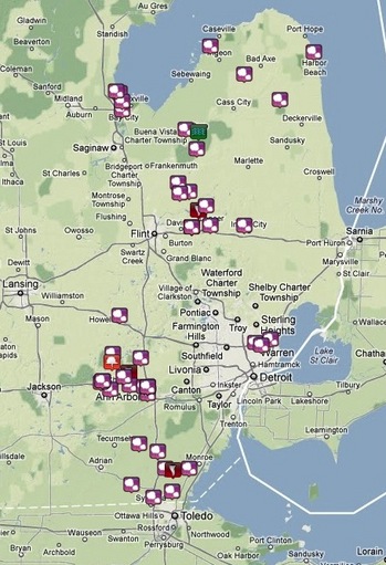
The map pinpoints sightings of tornadoes, funnel clouds and hail.
An accompanying chart helps track the path of the storm across the county. The first tornado confirmation was at 5:40 p.m. 2 miles northeast of Dexter, according to the chart. As the storm moved southeast, another tornado sighting was reported near Ida in Monroe County at 6:50 p.m. Another tornado was reported at 6:53 p.m. in Lapeer County.
Spotters first observed hail an inch in diameter in the Pinckney area just north of Washtenaw County at 5:07 p.m. Large hail up to 2 inches in diameter was observed throughout the county during the storm.
Spotters reported flooding in Ann Arbor at 6:30 p.m. with several roads covered with 3 to 4 feet of water.
Comments
jns131
Sat, Mar 17, 2012 : 3:18 p.m.
What still echoes with me is the fact that the weather spotters were spotting so many potential and actual tornadoes that one can be overwhelmed. Storm chasers have a very daunting task of making sure every one is safe. Including them. I can imagine this was a very long nite for all.
maxima284
Fri, Mar 16, 2012 : 6:25 p.m.
That's not completely accurate. There was a funnel cloud in saline and, at two different times in the day, there was hail.
maxima284
Fri, Mar 16, 2012 : 6:33 p.m.
Per Weather.com: trained weather spotters reported a funnel cloud near Saline