
New task force will develop vision for connecting North Main Street and Huron River
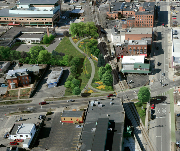
This graphic representation shows what a greenway anchor park could look like at 415 W. Washington St., one of three city-owned properties along the proposed Allen Creek Greenway.
Given some of the challenges at two other sites being considered for greenway parks, city officials think 721 N. Main could be the city's best bet for moving forward and building momentum around the decades-old vision of an Allen Creek Greenway.
To kick efforts into high gear, the Ann Arbor City Council voted 10-0 Monday night with Margie Teall absent to establish a new North Main-Huron River Corridor Vision Task Force.
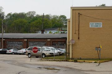
Ann Arbor Fleet Services facility, located at 721 N. Main St.
Melanie Maxwell I AnnArbor.com
This task force is expected to make a recommendation to the City Council for the best use of 721 N. Main as part of a proposed greenway by Dec. 31, 2012.
Sumedh Bahl, the city's community services administrator, said city staff will be working aggressively to put together a plan for 721 N. Main by the end of this year, one that can be used to seek grant funding from the Michigan Natural Resources Trust Fund.
The task force is being asked to develop a broader vision to enhance pedestrian and bicycle connections from downtown to Bandemer Park and Huron River Drive, as well as increase public access to riverside amenities and ease traffic congestion at Main and Depot streets.
Council members also want the task force to recommend a use for the riverside MichCon property off Broadway Street, where DTE Energy is undertaking a major cleanup project.
After conducting a series of public workshops, the task force is expected to submit a report on all of its recommendations to the City Council by July 31, 2013.
The resolution to create the new task force was co-sponsored by Council Members Sandi Smith and Sabra Briere, both 1st Ward Democrats.
Smith said pedestrian, bicycle and automobile access to Bandemer Park, which hugs the Huron River off Main Street near Argo Pond, is "not being done very well."
"A lot of times people are traversing private property, over the railroad tracks, into Bandemer," she said. "The city has even given up having a fence across where they had one before blocking that access because it was destroyed and removed so many times."
The city is working on getting FEMA grants to demolish two buildings that stand in the floodway at the fleet services garage at 721 N. Main.
Mayor John Hieftje said the city has had fruitful conversations with county parks officials and, while there's no formal agreement yet, they seem happy to consider cooperating with the city and putting out a matching grant like they did with the city's skatepark project.
"This would connect ultimately across Main Street," Hieftje said. "And then there's going to be work going on to get a tunnel under the railroad tracks to connect this with the border-to-border trail and that, I think, is a large hook that brings in other funders."
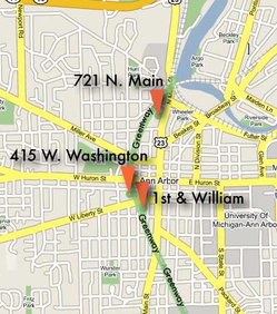
A map showing three city-owned sites that could become greenway parks.
Courtesy of Friends of the Ann Arbor Greenway
Bahl said that's unknown right now. Hieftje said the nonprofit Allen Creek Greenway Conservancy needs the first greenway park at 721 N. Main to be able to say "here we've got a start," and then more grant funding to connect to other proposed greenway anchor parks at 415 W. Washington and the northeast corner of First and William might be more forthcoming.
The city's professional planning staff is expected to begin its own Main Street corridor study project within the next two years. The idea is that the task force created Monday night can begin the community discussion now to establish a vision for improving the corridor.
The task force will include one member of the city's Park Advisory Commission, one member of the Planning Commission, one resident representing the Water Hill neighborhood, one resident representing the North Central area, one resident from the Old Fourth Ward, one resident representing the Broadway/Pontiac neighborhood, two business and property owners from the affected area, and one member of the Huron River Watershed Council.
Following improvements near Argo Dam, including creation of the new Argo Cascades, Smith said there is increased activity at the park areas along the river. The increases in bicycle and pedestrian traffic call for a better pathway across the railroad tracks, she said.
Hieftje said he's hopeful the city will have some luck working with the Michigan Department of Transportation on issues of access to the riverfront from Main Street.
"We are on the cusp of MDOT taking over the east-west rail line," he said. "And MDOT has a lot of the same goals that we do as far as facilitating pedestrian-cycling use, so it should be much easier to work with MDOT to get a way under the tracks, over the tracks, a way past the tracks, to connect this potential greenway pathway with the Border-to-Border Trail."
Council members heard an update Monday from David Esau, who has represented the Arts Alliance on a committee exploring creation of a greenway park and arts center at 415 W. Washington. The City Council approved a resolution in February 2010 inviting the Arts Alliance and the Allen Creek Greenway Conservancy to join the city in that effort.
Esau said there's no question the arts community is interested in a facility like the one the city has in mind, but it's going to take money and grant funds haven't been forthcoming.
He said foundations that could provide grant money want to fund something they know will happen and 415 W. Washington is unfortunately a long way from being at that point.
"Unfortunately we have not made a lot of headway," he said. "We're basically at a point where if the city is serious about seeing 415 redeveloped, it may be better to spend some money now to figure out whether that's feasible and what would be involved, rather than spending it down the line to pay for demolition when the building is deteriorated too far to be salvageable."
Esau said some of the work that is needed, such as hazardous materials investigations, would be needed anyway for either demolition or development of a greenway park.
As supportive of the project as the Arts Alliance is, he added, it's unable to continue working on the project without compensation.
But another group has emerged that has more experience in developing and managing arts facilities of this type and is interested in carrying the project forward, Esau said.
Sumedh Bahl, the city's community services administrator, said city staff will be working aggressively to put together a plan for 721 N. Main by the end of this year.
Ryan J. Stanton | AnnArbor.com
"We've been developing arts spaces. Currently we have three locations in Detroit," Goines said, citing old buildings that were renovated for studio, gallery and community arts spaces.
Goines said he's been meeting with the Ann Arbor greenway and arts center task force since January and discussing the possibilities for 415 W. Washington.
"The first step is moving forward with some of these surveys that need to be done to really determine the feasibility of the project," he said, citing a need for an additional $10,000 to $12,000 for surveys to determine if the building can be preserved.
He also expressed interest in moving forward with a hazard materials abatement plan, various feasibility analyses, and developing partnerships with other organizations.
As the old warehouse-style garage at 415 W. Washington continues to deteriorate, Hieftje said the city is going to have to do something with it eventually.
Noting the building is in a historic district, Hieftje said the city would have to petition the Historic District Commission for approval to demolish it if it ever went that route. He said he's still hopeful a greenway park with lots of sculpture and an arts center can happen.
"We have some new excitement around the project working with people who've done it before," he said. "We have high hopes."
Ryan J. Stanton covers government and politics for AnnArbor.com. Reach him at ryanstanton@annarbor.com or 734-623-2529. You also can follow him on Twitter or subscribe to AnnArbor.com's email newsletters.
Comments
Tru2Blu76
Sun, May 13, 2012 : 5:32 p.m.
Personally, I like the concept. As it is, just getting through the downtown area to the park /pond areas is a bit risky and not especially pleasant. But liking isn't knowing how or at what total cost.
Michigan Man
Wed, May 9, 2012 : 2:50 p.m.
Ranzini - allow me to be direct. Any plan to bring bicycle, automobile and/or pedestrian traffic closer to an operational rail line makes no sense. Mayhem, injury and death results from humans interacting, in any manner, with rail lines and/or rail traffic. 1000's of annual rail v. human deaths occur annually in the USA, despite our crushing safety regulations designed to obviate this data. When was the last time you rode a train, of any type? I speak from vast experience having rode trains in Chicago and Philadelphia, for years, back and forth to work and for pleasure. It is really quite simple: Trains and human just do not get along very well.
marqueA2
Tue, May 8, 2012 : 10:08 p.m.
"We are on the cusp of MDOT taking over the east-west rail line," he said. "And MDOT has a lot of the same goals that we do as far as facilitating pedestrian-cycling use, so it should be much easier to work with MDOT to get a way under the tracks, over the tracks, a way past the tracks, to connect this potential greenway pathway with the Border-to-Border Trail." This would be awesome.
SMC
Tue, May 8, 2012 : 9:48 p.m.
I wonder if part of the plan will involve repairing N. Main street without simultaneously narrowing it..
Alice Ralph
Tue, May 8, 2012 : 8:13 p.m.
There is no actual plan yet. I encourage those who are posting comments here to join the process. The process is likely to start in June. An interim recommendation on a concept plan for 721 N. Main is due Dec 31, 2012, to facilitate grant applications. The "corridor" is so complex that at least six more months will be needed to create a vision that is meets objectives as much as possible. The resolution language was strong on public workshops and other interaction. If our community joins the process in a substantive way, we are more likely to get something that we can both support and eventually enjoy.
Tru2Blu76
Sun, May 13, 2012 : 5:28 p.m.
Watch out now, your talking "dangerous" common sense to these people. lol! But as a matter of practicality, how does one become more involved in the Greenway Project?
Dog Guy
Tue, May 8, 2012 : 8:07 p.m.
To connect North Main Street and Huron River, increase the height of Argo Dam by fifteen feet.
rkb0929
Tue, May 8, 2012 : 6:08 p.m.
If you putting parking out there for people to have access to the water, etc., it seems the next logical step would be to try to get some restaurants to open out there....who wouldn't want to hang out if they've been out enjoying some time outdoors and be able to have a good meal or a drink or something....we don't need a bunch more parks though, in my opinion, especially with "sculptures" unless they are ones kids can play on!
bruno_uno
Tue, May 8, 2012 : 5:05 p.m.
Please provide safe access to cross tracks first in a feasible way before this project. You wouldnt build a subdivsion with houses first before the roads would you?
B2Pilot
Tue, May 8, 2012 : 4:32 p.m.
I am all for fixing up that end of main st. I think a large parking garage has to be part of the plan. A) it gives people going to the riverfront or parks a place to park once there B) it gives folks coming into the city a place to park and commute to where ever they are going in the city and keeps that traffic off the streets. C) it solves the fuller road parking / train station that was not viable given the location. I would re-think the tunnel - i can vision the homeless taking it over - and being creepy walking through at night even if it is lit up like others i've seen. just my quick observation If done correctly this will be a highlight for the city for the next 200 years. I don't always agree with council but you have my support for this, please do it right and don't rush to just do something for election year politics.
Larry Baird
Tue, May 8, 2012 : 3:33 p.m.
A pedestrian tunnel at Main and Depot does not solve the issue of connectivity to Bluffs park. If the Allen Creek Greenway followed the west side of the AA railroad tracks from Summit to the river (instead of crossing N. Main at Summit/Depot), a pedestrian bridge could be built across both N. Main St and continuing across the railroad tracks to the Bandemer/Argo bike path. This would solve both problems at once - connecting N. Main to the Argo pond bike path and connecting N. Main and the Allen Creek Greenway to Bluffs Nature Area. I would also point out that the proposed tunnel location is only three short blocks from the Broadway bridge which provides pedestrian and bike access to the new Argo cascades bike path which connects to the Argo pond bike path. Although not as convenient as the proposed tunnel, is it worth spending millions at this precise location when an alternative exists only three blocks away?
xmo
Tue, May 8, 2012 : 2:32 p.m.
There is a lot of discussion on this topic. Sounds like they are making a mountain out of a mole hill! Build it and say you are sorry later!
Dog Guy
Tue, May 8, 2012 : 8:02 p.m.
Being liberal means never admitting a mistake and certainly never saying you're sorry. And this is good because if they were to start doing those . . .
Jim Osborn
Tue, May 8, 2012 : 12:08 p.m.
An underpass would be expensive. Making the crossing level, with out the tracks being much higher and so easy to trip over would be a big help. Similar to how tracks cross a road. In California, I've seen pedestrian and bike crossings that have lights that flash when a train is approaching, some even have a small gate. In Europe, they have a passive "Z" curve thing that a person goes through so they know that they are approaching tracks, and cannot just ride through. Signs would be posted that say to look for a train, and it is on a straight section of track. Anyone older than 9 or 10 should be able to cross it safely.
foobar417
Tue, May 8, 2012 : 3:38 p.m.
Railroads have the right to refuse at-grade crossings. They almost always do. The only way is up and over or down and under. I believe the latter is cheaper, but either way it has to be AADA-compliant.
Larry Baird
Tue, May 8, 2012 : 3:10 p.m.
The level crossing would be less expensive, however, as MDOT takes over track ownership, the state will be less inclined to allow new "at grade" crossings. In fact, Eli Cooper stated that other states have closed some "at grade" crossings when upgrading the tracks for higher speed rail.
amlive
Tue, May 8, 2012 : 1:29 p.m.
An underpass may be expensive, but there's the potential it could be cheaper for the city. If placed strategically, this underpass could also contain a stormwater drain route to bypass the railroad berm, and perhaps (just perhaps) lower the floodplain level in the Depot//Summit/Main area enough to qualify for FEMA funding. I believe there may be some talk of looking in to this, but I've no idea if it will pan out. It'd be a nice bonus for some property owners there if it did work though. I do like the Z-curve concept, but I do think a straight crossing is not that big an issue either. It works with sidewalks along roads across the country, and seems should be just as fine with a sidewalk on it's own. They have a walkway across the tracks from Geddes to Gallup park, so I see little reason crossings like this couldn't be made elsewhere. Of course the people in that neighborhood probably have a bit more clout in getting what they want, but it should at least be a useful model and precedent for other areas.
Stephen Lange Ranzini
Tue, May 8, 2012 : 11:39 a.m.
I welcome the plan to create access to the bicycle trail along North Main Street near Argo Dam without having to (unsafely) walk bicycles across the railroad tracks. An underpass here would be a good use of taxpayer funds. The city already plans an underpass underneath the railroad tracks from the Border to Border Trail to West Huron River Drive, which is a prime scenic spot to bicycle. If an access point were made closer to downtown, this would increase usage and utility of the Border to Border Trail. As I noted in a recent column, better bicycle trails are an economic development engine, as it improves quality of life and makes the area more desirable to live in. Microsoft relocated from Albuquerque, N.M., to Redmond, Wash., early in its corporate existence, for example, primarily because Redmond had the Sammamish River Trail, a 10.9-mile bike path and recreational rail trail.
Stephen Lange Ranzini
Wed, May 9, 2012 : 1:49 a.m.
@Michigan Man: the Border to Border bicycle trail is already there and has been for many years. Do you propose closing the trail there and in Geddes Park too?? A safe access point under the tracks is all I am suggesting. FYI, at that point the trains won't be going very fast as they will be going around a sharp bend and either slowing to stop at the Ann Arbor train station or just accelerating having departed fom the train station. Lastly, are you aware of any train tragedies where bicyclists were killed in a train crash as they rode along a path near train lines?
Michigan Man
Tue, May 8, 2012 : 10:05 p.m.
As I noted in a recent post, a bicycle trail makes absolutely no sense adjacent to a rail line which will carry Detroit to Chicago traffic at 110 MPH. Access points (Underpasses) to rail lines are for resident and pedestrian/biker safety, not for scenic and/or esoteric purposes. Chicago, for instance, is a city with an active rail system used for many purposes, including commerce and transporting millions of suburban residents to the downtown area for work. Fatalities and mayhem are a daily and common occurrence along most rail lines. Humans are urged to stay away from the the rail lines, not enticed to bike, walk close to and other hang around rail lines. The Ranzini plan/thinking is poorly considered, makes little sense and is dangerous to the public health of Ann Arborites.