
Embankment failure closes Plymouth Road in Ann Arbor, floods shut two county routes
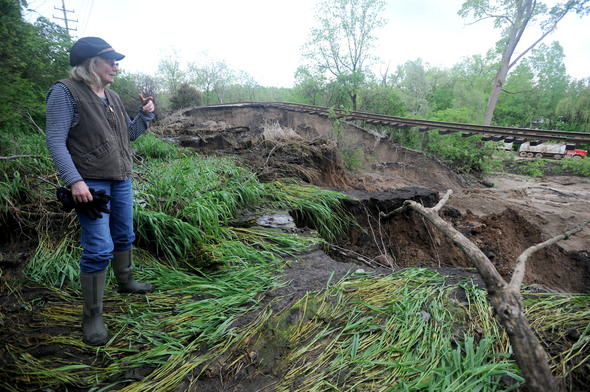
Sarah Byers stands near sagging railroad tracks at the spot where an embankment washed away near Plymouth Road in Ann Arbor on Wednesday night.
Angela J. Cesere | AnnArbor.com
(Update: City officials announced that Plymouth Road is open again as of early Friday afternoon. See the story here.)
Heavy rains Wednesday caused an embankment failure under the railroad tracks that run parallel to Plymouth Road in Ann Arbor, closing the road and buckling the tracks.
The road is expected to be closed for most of the day today. Ann Arbor Railroad officials told police last night that it would take two to three weeks to makes the tracks usable again. No trains had to be stopped because of the embankment collapsed, according to Lt. Myron Blackwell of Ann Arbor police.
About 2,000 cubic yards of mud and trees slid across five lanes of Plymouth Road around 9:23 p.m. Wednesday after three inches of rain fell in a 24-hour period, an Ann Arbor official said.
A notice posted on the city's website said Plymouth Road is closed between Barton Drive and Broadway while crews work to clear both lanes after an embankment failure occurred late Wednesday night due to heavy rain.
Ann Arbor Police called the Ann Arbor Railroad at about 10 p.m., and inspectors were on the scene by 11:30 p.m.
"There was never any danger of trains being derailed because of this," Blackwell said.
Clearing the roadway is slow going, according to an e-mail sent to Ann Arbor City Council members at 9 a.m. today.
"Trees have to be removed pulled out of the mud and then loaders can take a few scoops of mud, then more trees removed," the official wrote. "This sequence has to be repeated thousands of times to work through the mass of material."
Crews are at the scene trying to clear away debris from the street. A large section of the embankment washed out from beneath the tracks, leaving them unsupported. The collapse is east of the intersection of Traver Road and Bowen Street.
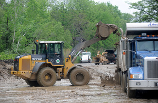
Road crews clean up debris and mud Thursday afternoon on Plymouth Road after an embankment washed away under railroad tracks nearby.
Angela J. Cesere | AnnArbor.com
City Council Member Sabra Briere, D-1st Ward, who lives near the embankment collapse, walked to the area to examine the damage around 8 a.m. today. She said neighbors who live on Traver Road said they lost the pond in their back yards when the embankment gave way. “The railroad embankment among other things held up a pond," Briere said. "The pond was spring fed. When the embankment failed the pond let loose, the pond behind houses on Traver Road is now gone.”
Sarah Byers, who has lived on Traver Road for 25 years, heard about the mudslide from a neighbor last night and walked into the woods behind her house at 7:30 a.m. today to check it out. She found that a 45-yard long section of the foundation of the railroad tracks had been swept away, leaving a massive hole.
"When I looked through the trees, I could see there was nothing beneath the tracks," she said. "But I had no idea. It was pretty wild."
Heavy rains Wednesday have also caused flooding on other roads.
In Scio Township, Liberty Road west of Zeeb Road is flooded and has been closed, said Jim Harmon, director of operations for the Washtenaw County Road Commission.
In Salem Township, Chubb Road between Six Mile Road and Seven Mile Road is closed due to severe flooding and road washout, the Road Commission said. The road will remain closed to the public until further notice.
Lima Center Road between Hieber Road and Bethel Church Road in Freedom Township remains closed because of earlier flooding.
Harmon said water has receded on some roads that were flooded Wednesday.
View Plymouth Road closed in a larger map
Reporters Lee Higgins and Juliana Keeping contributed to this report.
Comments
jns131
Fri, May 27, 2011 : 7:19 p.m.
Wow! Talk about a dip in the tracks. What a cool ride that would be. Just a little bit bigger and that would be an awesome ride. What a mess Plymouth road is at Barton. Glad I am not anywhere near there.
Dog Guy
Fri, May 27, 2011 : 3:58 p.m.
I remember when the city widened Plymouth Road from two lanes to five lanes. I think that the RR embankment was carved to make room.
Craig Lounsbury
Fri, May 27, 2011 : 10:39 a.m.
Isn't this the same choo choo train track the mayor wanted to use to shuffle commuters from Livingston county to Ann Arbor?
godsbreath64
Fri, May 27, 2011 : 6:37 a.m.
Great photography, Angela Cesare! You should see many awards for these.
Momma G
Thu, May 26, 2011 : 9:50 p.m.
How about "Rain, rain, go away..."
KJMClark
Thu, May 26, 2011 : 9:04 p.m.
And since David and My2bits brought the topic up, I sure hope that people are out inspecting the embankments for the various dams in the area. If anything's going to fail, it will be during a very wet spring like this one.
blahblahblah
Fri, May 27, 2011 : 1:18 p.m.
Not sure why the DEQ required removal of the trees along the Argo raceway embankment? Seems like the tree roots would help anchor the embankment.
My2bits
Thu, May 26, 2011 : 8:26 p.m.
<a href="http://gizmodo.com/5802243/this-is-what-happens-when-you-mix-floods-and-railroads" rel='nofollow'>http://gizmodo.com/5802243/this-is-what-happens-when-you-mix-floods-and-railroads</a>
NUXI
Thu, May 26, 2011 : 8:54 p.m.
Pfffft, this is what happens when you mix floods and railroads: <a href="http://www.me.mtu.edu/~jadevree/iowa/IMG_0008.JPG" rel='nofollow'>http://www.me.mtu.edu/~jadevree/iowa/IMG_0008.JPG</a> <a href="http://www.me.mtu.edu/~jadevree/iowa/IMG_0009.JPG" rel='nofollow'>http://www.me.mtu.edu/~jadevree/iowa/IMG_0009.JPG</a> <a href="http://www.me.mtu.edu/~jadevree/iowa/IMG_0010.JPG" rel='nofollow'>http://www.me.mtu.edu/~jadevree/iowa/IMG_0010.JPG</a> <a href="http://www.me.mtu.edu/~jadevree/iowa/IMG_0011.JPG" rel='nofollow'>http://www.me.mtu.edu/~jadevree/iowa/IMG_0011.JPG</a> <a href="http://www.me.mtu.edu/~jadevree/iowa/IMG_0012.JPG" rel='nofollow'>http://www.me.mtu.edu/~jadevree/iowa/IMG_0012.JPG</a>
bedrog
Thu, May 26, 2011 : 8:01 p.m.
nyah nyah! see?? yours , "dr".harold camping
5c0++ H4d13y
Thu, May 26, 2011 : 7:11 p.m.
Looks like the armageddon is on a slow roll.
Bogie
Thu, May 26, 2011 : 6:27 p.m.
Street, drive, way, whatever. Seems, some people have too much time on their hands. I liked the photos, it's hard to believe, what water can do!
Top Cat
Thu, May 26, 2011 : 5:44 p.m.
As a revenue raising opportunity in the interim, the Ann Arbor Railroad could get a few handcars and sell roller coaster type rides over the sagging trackage. I'll bet they could charge amusement park pricing. They would sell a lot of pictures as well. It could take about 1/2 hour for riders to sign all the waivers though.
David Cahill
Thu, May 26, 2011 : 5:29 p.m.
How come the embankment didn't have toe drains like the Argo Pond embankment does, to handle seepage from rains like this one?
My2bits
Thu, May 26, 2011 : 8:27 p.m.
Is this what the DEQ was worried about happening on the embankment by the dam? Seems like it.
CC
Thu, May 26, 2011 : 8:14 p.m.
wonder which jurisdiction is responsible for putting a culvert underneath. The problem with the pond is not only is it spring-fed, it is also fed by a storm sewer serving Traver Road and Pear St.
KJMClark
Thu, May 26, 2011 : 7:57 p.m.
It probably does, but like the Argo embankment, those drains aren't usually perfectly maintained. Besides, this is a pretty heavy rainfall, and we've had extra precipitation since last winter.
blahblahblah
Thu, May 26, 2011 : 4:23 p.m.
The embankment failure has me curious as to what type of freight moves through town? From Plymouth Rd. across the river and through most of downtown that whole section of track runs along an elevated embankment. Most sections of the embankment does not back up to a pond however.
blahblahblah
Thu, May 26, 2011 : 6:38 p.m.
Thanks for the info. Nice to know nothing toxic is being tranported. If some of the cars are carrying sand, I would assume that's a pretty heavy load. Luckily the failure occurred when it did (without a train present). It was mentioned in a previous post that a pond existed next to this site which may (or may not) have helped contribute to the failure. While no ponds exist next to the downtown elevated sections, they do run very close to the buried Allen creek, so hopefully those sections are not being impacted by all the water.
Alex
Thu, May 26, 2011 : 5:51 p.m.
Most of the freight is bridge traffic form the AARR in Toledo, and the GLCRR, meeting at Osmer between Warren & Joy Road. Sand from Yuma used to be for a Cleveland engine casting plant, now mostly it's Frac Sand. There's also a lot of plastic pellets, and grain shipping as needed. As for the embankment through AA, that was many years ago to raise the height of the tracks - nothing to do with any water retention.
Charlie Brown's Ghost
Thu, May 26, 2011 : 4:35 p.m.
I believe the Ann Arbor Railroad hauls sand and grain through the Ann Arbor area. Good Night and Good Grief.
Richard C
Thu, May 26, 2011 : 4:16 p.m.
Also, yesterday (5/25) during the rains at around 3:15pm, I encountered flooding on Madison and Fourth (near Fingerle's). Most people were doing the sensible thing and turning back, but one brave fool tried crossing the flooded part in his car. I think he made it, but it was a foolish and impatient thing to do.
Richard C
Thu, May 26, 2011 : 4:11 p.m.
I was driving south west on Plymouth Rd Wednesday (5/25) at about 3:15pm when I came across a school bus trying to move away from the hill-side lane to avoid a fallen tree that was blocking that one lane. I called it in to the AA Police about 3:30pm (didn't seem right to call from a moving vehicle). The rain was heavy at the time, and there was some lightning - so I thought that the fallen tree was due to lightning, but now I suspect it was the beginning of the mudslide.
Ann English
Thu, May 26, 2011 : 3:54 p.m.
What will the freight companies do for the next month, if they want to ship freight north? I know there's a connecting track between the two tracks, crossing North Main Street. A northbound train on the Ann Arbor Railroad could get off of it right before the bridge over the Huron, and head west, upriver. I don't know where a southbound train could get off the track if it's north of Barton Drive.
Alex
Thu, May 26, 2011 : 5:32 p.m.
That interchange has not been used / needed in decades. It may be reinstalled if the commuter trains with the Great Lakes Central works out. Freight going to and from the GLC will probably be routed over CSX or CN for a while.
Richard C
Thu, May 26, 2011 : 4:13 p.m.
The rails that connect the N/S tracks with the E/W tracks are overgrown with trees, and the track crossing over Main is paved over. It would take months to rehabilitate that connection.
Ann English
Thu, May 26, 2011 : 3:47 p.m.
The journalists did an adequate job this time describing where the railroad track is located, this time something took place far enough away from Argo Canoe Livery, where one track (north-south) crosses both the Huron River and the other (east-west) track.
MOTAY
Thu, May 26, 2011 : 3:44 p.m.
A month? You gotta be kidding me David?!?!
NUXI
Thu, May 26, 2011 : 9:05 p.m.
I'm not entirely sure what goes into building a railroad grade, but the estimate does not surprise me if this is not an immediate priority. This has to support a multi-hundred (if not thousand) ton freight train, not your family car. They will probably demolish the embankment back a bit from each side as well as have to replace the rails and timber. They may need to resurvey the land itself before doing any of it. They may also be chosing to wait for the ground to not be quite as saturated with water as it is right now, which may require waiting a few days. I bet they could do it faster if it was an absolutely critical section of railroad, but there is no reason to do a rush job otherwise.
silverwings
Thu, May 26, 2011 : 3:36 p.m.
Hey, we can repurpose it as a new roller coaster.
EyeHeartA2
Thu, May 26, 2011 : 2:36 p.m.
PIctures, or it didn't happen.
EyeHeartA2
Thu, May 26, 2011 : 2:48 p.m.
..or maybe I missed that one at the beginning of the article. I guess I was looking at the map area. No proofreader job in my future.....
MjC
Thu, May 26, 2011 : 1:48 p.m.
Row, row, row your boat gently down Plymouth Road. Merrily, merrily, merrily, merrily life is but a dream.
David Cahill
Thu, May 26, 2011 : 1:09 p.m.
Sabra and I just go back from looking at the embankment collapse. It is between Traver on the north and Plymouth Road on the south, close to the intersection with Broadway. The ground supporting the railroad track is missing. There is at least 100 feet of track just hanging in the air! Sabra got some pictures. The track is not the east-west Amtrak railroad. Instead, it is what used to be called the Ann Arbor Railroad, which is all-freight. Gossip collected at the site indicates that this track will be closed for at least a month.
Jeff Renner
Fri, May 27, 2011 : 12:37 p.m.
Wow, David, that sound just like what a reporter would do!
Cash
Thu, May 26, 2011 : 2:20 p.m.
Thanks for the info regarding the track. I was hoping it was not Amtrak track involved.
Charlie Brown's Ghost
Thu, May 26, 2011 : 1:38 p.m.
I believe at that point it is still the Ann Arbor Railroad. Somewhere north of there ownership changes to the Tuscola & Saginaw Bay Railway. The AAR is a small company with about 50 miles of track. I hope the combination of this disruption and the economy doesn't kill them. Good Night and Good Grief.
ycoty05
Thu, May 26, 2011 : 12:58 p.m.
The railroad above Plymouth Road (visible from Traver rd) is collapsed -- it looks like a rollar coaster track now! I hope someone from the AANews takes a picture..
NerdyDave
Thu, May 26, 2011 : 12:30 p.m.
To be completely pedantic, the description is STILL potentially misleading, as Plymouth & Broadway intersect twice -- once at the top of the hill, again at the bottom of the hill.
David Cahill
Thu, May 26, 2011 : 12:16 p.m.
The City's notice refers to "Broadway Road", which does not exist. The official name is "Broadway Street". But the "Street" is redundant. On early maps it is "Broad Way". "Way" means "Street". We should be happy, though, that the City managed to post a notice at all - even one with three nomenclature errors. After all, the embankment collapse is a serious situation.
Cindy Heflin
Thu, May 26, 2011 : 10:32 a.m.
City notice says Huron Drive, but yes, Huron Street would be correct.
Cindy Heflin
Thu, May 26, 2011 : 11:15 a.m.
Indeed
UM owns
Thu, May 26, 2011 : 11:12 a.m.
And Glen is spelled with one "n".
Basic Bob
Thu, May 26, 2011 : 10:16 a.m.
"Glenn to Huron Drive" Glen Avenue to Huron Street?
Steve Hendel
Thu, May 26, 2011 : 10:27 a.m.
Carrying on the AA News typo tradition