
Superstorm Sandy update: Worst over in Ann Arbor, but wind, cold will linger
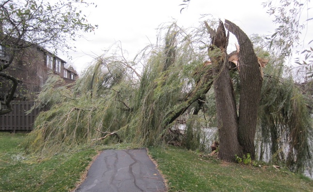
The high winds spawned by Sandy were too much for this willow tree on Meade Court near Logan Elementary School in Ann Arbor.
Photo courtesy of Ingrid Ault
A wind advisory for the Ann Arbor area expired Tuesday afternoon, but the former Hurricane Sandy, now dubbed Superstorm Sandy, will continue to bring rain, wind and cold to the Ann Arbor area for the next few days, the National Weather Service said.
“The worst is over," said Sara Schultz,” a meteorologist with the National Weather Service in White Lake Township.

University of Michigan junior Margaret Zhang walks to her economics class as a gust of wind buffets her Tuesday afternoon.
Daniel Brenner | AnnArbor.com
The storm brought down limbs and trees in Ann Arbor and throughout the county.
The DTE Energy outage map showed power had been restored for many customers in Washtenaw County who had been without power earlier Tuesday. Power was still out shortly after 2 p.m. for more than 800 customers in Ypsilanti and more than 500 in Scio Township.
DTE reported it had more than 100,00 customers without power in southeast Michigan shortly before noon.
The effect of Sandy in southeast Michigan paled in comparison to the havoc she wrought on the East Coast. The storm killed at least 38 people and left millions without power. The full extent of damage was still being assessed Tuesday.
For the rest of Tuesday, Ann Arbor area residents can expect scattered showers and cloudy conditions with a high near 41. Winds will blow from the north at around 23 mph with gusts as high as 32 mph.
Showers are likely Tuesday night, mainly after 8 p.m. The low will drop to about 36. Winds will continue, gusting to 28 mph at times.
Wednesday, showers are likely early; then it will be cloudy with a high near 55. Winds will gust to 23 mph.
The clouds will stay with us Thursday, and winds will continue to blow with gusts up to 24 mph.
The sun is expected to return Friday, but temperatures will remain below normal, with the high climbing to around 44.
For weather conditions and forecasts anytime, visit AnnArbor.com's weather page.
Comments
mady
Wed, Oct 31, 2012 : 1:55 p.m.
Good Riddance Sandy!!
justwondering
Tue, Oct 30, 2012 : 7:33 p.m.
It should read: "The effect of Sandy..." not "The affect of Sandy..."
jns131
Wed, Oct 31, 2012 : 5:17 p.m.
I've been hearing Sandy being called Frankenstorm Sandy. It was wild and wooly out there. Glad things are calming down. Good luck to NJ residents.
elganned
Tue, Oct 30, 2012 : 8:14 p.m.
So hard to find good editorial help these days...
Julie Baker
Tue, Oct 30, 2012 : 7:35 p.m.
Thanks, that's fixed.
Billy
Tue, Oct 30, 2012 : 7:21 p.m.
Aww so sad to lose a good size tree like that. There's so much of it left would it be possible for an woodcarver to fashion something out of the "stump?"
mady
Wed, Oct 31, 2012 : 1:54 p.m.
Billy, good idea