
Geotagging in 1897: a 'postal memory map' of Washtenaw County
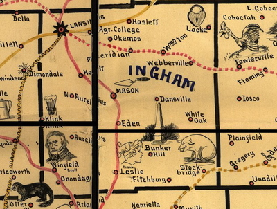
Littered with tiny, charming pictures and colored lines showing railroad routes, the map was a mnemonic device meant to help people pass the qualifying examination to work for the railroad mail service.
The pictures helped the test-takers remember the stations along each route.
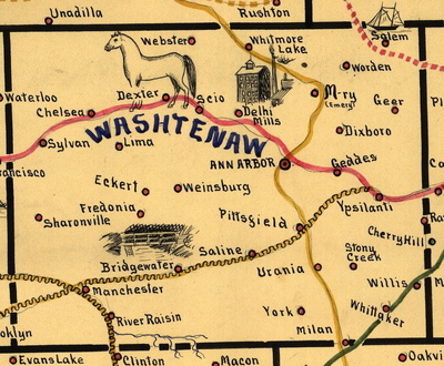
Examining the Washtenaw portion of the map, one can see a picture of a bridge over water near Bridgewater, and an image of a four-story-high mill near Del-“high” Mills. Near Salem, a ship image refers to the Massachusetts town famous for witch trials and clipper ships.
A horse looms over Dexter, and alludes to the Seabiscuit of the 1860s. The famous racehorse Dexter broke two world records in 1867. Scribner’s magazine called him “the horse of the century.” The railroad clerks studying the map before the exam in the 1890s would have recognized this icon.
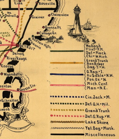
The Lake Shore and Michigan Southern Railway appears as a yellow squiggle. In the northeast corner of the county the Detroit, Grand Rapids, and Western railroad passes through. The green line to the southeast marks a route shared by the Wabash, Flint, and Pere Marquette, the Detroit-Mackinac, and the Chicago-West Michigan Railway railway companies.
This map was introduced to the author by a local history buff, who noticed some interesting drawings that he mentioned in an email.
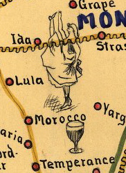
"I don't know if there are any bars in Temperance today.” There are—it’s the author’s hometown.
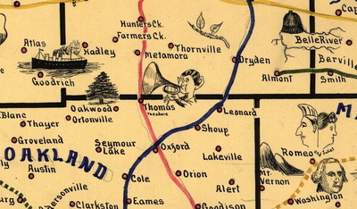
He continued, “The other thing I noticed was a number of famous faces, e.g. Franklin and Grant for those cities. Other faces may have been famous at the time, but aren't now. For instance, Thomas, in north Oakland county, had
Quaint as it is, this map is remarkably similar to the varieties of digital map enhancements created today with such combinations of tools as Google maps, digital photos, textual comments, and GPS information.
This similarity also occurred to writer Alex Wright, the New York Times's director of user experience and product research and the author of Glut: Mastering Information Through the Ages. In an article about postal memory maps on his blog, Mr. Wright wrote, “This seems like a good historical examplar for the kinds of things people are doing with social mapping these days: overlaying personal experience onto geographical maps, and in the process transforming the maps from static reference tools into living social documents.”
His 1897 Michigan postal memory map remains a living social document, communicating to modern readers its era’s famous horses, well-known musical figures, and old memes--and the endearing whimsy of a postal clerk a century ago.
Additional resources: Browse the entire map Purchase the Michigan map
Quoted material is reprinted with permission.
Laura Bien is the author of "Stud Bunnies and the Underwear Club: Tales from the Ypsilanti Archives," to be published this winter. She also writes the historical blog "Dusty Diary" and may be contacted at ypsidixit@gmail.com.
Comments
cmadler
Mon, Nov 9, 2009 : 11:35 a.m.
I agree with Sandy D, a look at some of these outlying communities would be interesting. My guess is that as transportation improved (sped up), travelling 5 miles to a larger town became less and less of an obstacle, and people gradually stopped thinking of their area as an independent community. But this would still make an interesting topic.
Sandy D.
Sun, Nov 8, 2009 : 1:16 p.m.
Very cool - now how about a story on what happened to Urania, Weinsburg, and Geddes? Do any traces of them as independent communities remain?
Laura Bien
Sat, Nov 7, 2009 : 1:19 p.m.
Thanks, Neo! I'm making a mental note to keep an eye out for other old, unusual maps like this!
Neo
Sat, Nov 7, 2009 : 11:49 a.m.
Pretty cool.
Laura Bien
Fri, Nov 6, 2009 : 8 p.m.
youngdz79: Thank you for your nice comment! I too added to my own knowledge of my home state--e.g., there are a lot of towns sprinkled around that simply don't exist any more, like Unadilla (though there's still an Unadilla cemetery, right on the county line there. Very pretty one, too).
Laura Bien
Fri, Nov 6, 2009 : 7:58 p.m.
Mr. C.: I too adore old maps, especially this one. I'm definitely putting the largest-size version on my Xmas list! It's a completely unique and fascinating map. I was looking at it for quite a while! Glad you liked it! Colon...isn't that where the magic festival, or museum, is?
Laura Bien
Fri, Nov 6, 2009 : 7:57 p.m.
Ed: Thank you for your lovely comment! I had a feeling this was the sort of topic you'd enjoy, and I'm glad you do! :) Thank you for that link. Interesting stuff! I noted this with interest: "there has been no definitive study on the history of Dixboro or how the village fared after the railroad from Detroit was completed to Ypsilanti in February 1838 and to Ann Arbor in October 1839 21. This would have significantly reduced the traffic on the Ann Arbor - Detroit Road through Dixboro and Plymouth. Chapman in 1881 notes that an 1859 article in the Ann Arbor Journal stated that after John Dix left, c1833, the village was on the wane." Hadn't known Dixboro was that old. Wonder what did happen after the train came through...hmm...
youngdz79
Fri, Nov 6, 2009 : 4:57 p.m.
This was a really cool article I just added to my knowledge of my home State
Duane Collicott
Fri, Nov 6, 2009 : 1:59 p.m.
Very interesting. I love maps, especially old ones. Too bad he didn't make a drawing for Colon.