
FOIA Friday: Arbor Oaks, Bryant flooding and drainage followup
Telling a story based on public records can take a long time. It's rare that a piece of information that's widely available to the public from a single government agency tells an entire story all by itself, and it's rare that a big, complicated set of records turns into a neat story quickly. You may think that you have everything you need to know, but it turns out that an agency in another jurisdiction across the street really has the written record and you are working from something incomplete.
At best, perhaps, you chip away at a big story with a series of little stories, told one photo or three paragraphs or a single line at a time, metered out through the process of daily journalism with the odd blog entry or wiki update to keep track of the details and salt away the odd fact that needs to be brought back to mind as needed.
Here is some fragment of a story that I don't understand, illustrated in part with the public records that were provided to me recently by the City of Ann Arbor and combined with reporting that has been done at AnnArbor.com. Something doesn't quite make sense, and I need to write down what I think I know to understand the gaps.
Every 10 years or so, the area gets a rainstorm which messes up some people's houses. Somewhere, there's a map of where that happens, and a map of what is being done to fix it. If the maps don't line up — if your problems don't show up on someone else's map — there may be trouble that lingers long after the event.
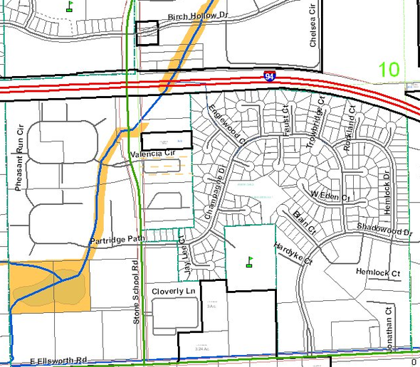
Image from MapWashtenaw
The neighborhood in question is known by several names. On the plat books, it's the Arbor Oaks neighborhood; to the neighbors, it's the Bryant neighborhood. It's located south of I-94 between Ellsworth and the freeway.
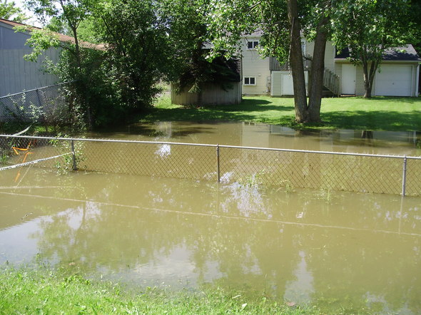
Photo courtesy of the Bryant Community Center
There are three perspectives on the problem of periodic flooding in the neighborhood. One is illustrated neatly by an AnnArbor.com story from June 2010, Residents want Ann Arbor City Council to form task force to address flooding in Bryant neighborhood. Residents in the Bryant neighborhood say they've been contending with flooding on and off for years, and the story quotes a home survey of the issues they face:
"Of 147 households who returned a survey, 90 percent indicated problems with water flooding and pooling in their yards or dampness and moisture in their crawl-spaces. Homes weren't built with basements. Surveys also pointed to a significant concern for respiratory problems, presumably from hidden mold caused by the dampness. The surveys were given to 286 households."
A second perspective on the same problem comes from the City of Ann Arbor's Systems Planning Unit. I was given three sets of records showing "basement back-up calls that were made to the city as a result of the last 3 major city-wide storm events". Amazingly, if you plot this data on a map, you can get a great big area around the Bryant neighborhood that looks perfectly dry.
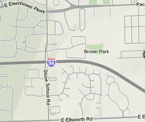
Data: City of Ann Arbor Systems Planning Unit. Base map: Google
Of course, this doesn't make any sense; how can it be that flooding on and off for years doesn't make it onto not one but three city planning maps?
I don't have that answer. I will point out, however, a piece of this story that I hadn't pieced together before starting to type. The Systems Planning data set is "basement back-up calls". The Bryant/Arbor Oaks neighborhood homes "weren't built with basements." Â Thus there is no basement to flood, and no record in this data set of the events.
The office of the county water resources commissioner — an office which was known as the drain commissioner when the subdivision was built — is a possible further source of information.
Asking more questions than you answer
A bunch of questions are left unanswered by this foray into public records.
Is there going to be a commission or other public body to address the problem of the Arbor Oaks drains? After the citizen attention to the problem in June, the Ann Arbor City Council has been silent.
What records does the Water Resources Commissioner keep regarding flooding, and how does one inspect those records in person?
Is there some other part of the City of Ann Arbor, Washtenaw County, the State of Michigan, or some far-flung part of the US Federal Government that has jurisdiction or oversight or even just some kind of record about what actually happens to the water in this corner of town when it rains?
Is there some kind of meter, gauge, satellite imagery, or other remote or local sensing that would give a record of soil moisture and standing water for the affected times?
Obviously not all of these can be answered at once, but if you can ask them faster than people can answer them in a form that demands a written response you can get a certain amount of leverage over the process, if leverage is needed.
Edward Vielmetti wrote about gunk on September 1, 2010 for AnnArbor.com and writes the FOIA Friday column about public records every Friday. Contact him at edwardvielmetti@annarbor.com.Â
Comments
Paul Cartman
Sat, Sep 11, 2010 : 10:49 a.m.
Regarding the author's questioning why there are not more documented reports of basement flooding in Arbor Oaks, the reasons may be multiple. As the author noted, the houses in this neighborhood generally do not have basements. Any "flooding" than is not experienced by residents and homeowners as an acute, identifiable event such as water rushing in through a floor drain; rather, we have chronic wetness in our yards and crawl-spaces throughout the year, worsening at times and abating at other times depending upon weather and climate. Since the water problem is ongoing and insidious, at what point would we, the residents of Arbor Oaks, call to report flooding--three inches of standing water or eight inches?Further, we experience the water as ground water and/or precipitation accumulation, not drain backup, so who would we call?There may indeed be an appropriate party to contact each time we experience pre-determined water levels, but we don't know who it is so we historically don't call. My point is that the problem is absolutely real! I have owned more than a dozen houses in this neighborhood over the years, and have been inside of no less than thirty others as potential purchases. I have seen a representative sample of Arbor Oaks properties, and can affirm the water problem here. I'd like to see this conversation focus on potential methods to resolve the problem above figuring out which government agencies and satellite photos should be used to document the problem. This forward-looking, resolution-based focus is where a task force might come in. Regarding an earlier comment about the Englewood-I94 clogged culvert, this is great information. Researching who is responsible for maintenance of this drain is worthwhile. Let's not lose the big-picture focus though, because getting MDOT to clear the drain at the end of Englewood, while helpful, will not remediate all the standing water issues in the neighborhood as this drain was just one of many purpose-built surface-water-remediation measures incorporated in the original build-plan for the neighborhood--swales and catch-basins connected to city storm drains are equally or more important. Hopefully a task force can figure out how to restore or find alternatives to the once-synergystic relationship between private run-off drains and the city storm water system!
Alan Benard
Fri, Sep 10, 2010 : 6:43 a.m.
The previous reporting you cite quotes the City of Ann Arbor's opinion that this problem belongs to the individual homeowners, because the now-collapsed French drainage ditches and swales originally dug by the neighborhood's long-gone builders are on private land. If this is a legal fact (which needs to be proved out in court), then the homeowners need to create an association and get the French drains, etc. re-dug. I'm guessing that -- if you found the right documents -- you could unearth the smoking gun that states the drains are on the utility easements, owned by the homeowners but controlled and maintained by the city. In any case, the city's opinion is unhelpful to a fairly large number of homeowners -- whose homes arguably shouldn't have been built where they are, or the land graded as it was -- who happen to be on average too broke to do anything about their problem individually. If the council and the mayor wished to make real the poses they take about diversity and inclusiveness -- while bending over for every wealthy near-downtown NIMBY coalition in town which fights development -- they would figure out a way to get the very simple job of re-trenching this subdivision and preserve the property values they tax.Until then, please keep digging. And while you're at it, ask MDOT when they plan to clear the pipe running under I-94 to Mallett's Creek (represented by an extremely thin blue line extending from the end of Englewood Ct. on your first map) which is now plugged, and clearly on its easement.