
FOIA Friday: Michigan oil pipeline spill map and safety information

Petroleum Pipeline warning symbol
The wheels of far-off bureaucracies are also spinning into action, and this week's FOIA Friday focuses on public records available from PHMSA, the Pipeline and Hazardous Materials Safety Administration. This organization keeps track of the nation's oil and gas pipeline infrastructure, and its monitoring and enforcement systems provide a trail of information and some maps about incidents relevant to the residents of Washtenaw County who should be aware that a piece of the Enbridge system runs right down the western edge of the county through Pleasant Lake.
Pipeline maps
Essential to the understanding of any problem is a good map. I will illustrate with maps of the petroleum pipeline owned by Enbridge that runs from Stockbridge to Samaria to Toledo, known internally at Enbridge as "Line 17".
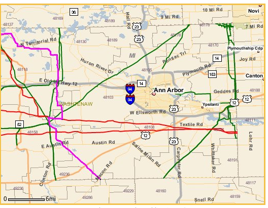
A purple line marks the approximate path of Enbridge's Toledo "Line 17". The line, which carries crude oil, is connected to Enbridge's "Line 6B" at Stockbridge, Michigan; it heads south to Samaria in Lenawee County before terminating in Oregon, Ohio.
National Pipeline Mapping System
The National Pipeline Mapping System (NPMS) is run by the Pipeline and Hazardous Materials Safety Administration (PHMSA), which is in turn part of the US Department of Transportation (DOT).
An additional mapping system known as PIMMA is available to emergency managers. in the 2008 article U.S. DOT Provides Secure Access to the Nation's Pipeline Data with GIS Claiborne Ashby, NPMS Project Manager, writes:
In 2001, Baker developed an ArcIMS Web site called the Pipeline Integrity Management Mapping Application (PIMMA) to share NPMS data with the general public. However, after the terrorist attacks of September 11, 2001, PHMSA conducted a data security review in conjunction with other federal agencies and decided to provide only limited public access to NPMS data. From September 2001 until April 2007, PIMMA had only been accessible to federal, state, and local government agencies and pipeline operators.
The Public Map Viewer for pipeline maps is a limited version of the full PIMMA application. Information cannot be downloaded, and the resolution of maps is 1:24,000 available one county at a time. Missing from the public view is information key to emergency management, such as where water resources are at risk, including details of "high-consequence areas (HCAs)", which include sensitive ecological and drinking water areas.
Pipeline safety
Pipeline safety information is held in a system called PRIMIS, also run by PHMSA.
Reporting is available on a number of levels, including a handy breakout by state. The Michigan pipeline safety page has lots of summary statistics, like pipeline mileage by county. Washtenaw County has 268 miles of gas pipelines and 99 miles of liquid pipelines, representing 3 percent of the state's total mileage.
The safety reporting includes summary reporting by operator. This chart of Michigan hazardous liquid spills, 2000-2009, lists two incidents on the Enbridge Toledo line. In February 2003, 130 barrels of hazardous liquids were spilled at Samaria due to "natural force damage" caused by temperature extremes. An April 2006 coupler failure in Britton led to a 25 barrel spill.
Pipeline safety enforcement
PMHSA is also in charge of pipeline safety enforcement. The agency's latest relevant action is the Corrective Action Order (PDF) of July 28, 2010, which specifies that the line between Marshall and Stockbridge shall not be restarted until a number of safety conditions are met.
When pipeline spills are bad enough, the National Transporation Safety Board gets involved in the after-accident review. This NTSB analysis of an Enbridge spill in North Dakota in 2004 is an example.
FOIA and the spill
Nothing described so far has required the FOIA process to work, but there are unanswered questions with which FOIA requests might help.
PHMSA maintains a FOIA reference page, with a FOIA reading room giving access to the more frequently requested documents.
Some portion of the timeline as to the exact events of the spill, including the time when a leak was first identified by first responders, is unclear at this point. A request for 911 call logs from the Calhoun County Sheriff's Office Support Services could make the initial timeline more clear.
Edward Vielmetti writes the FOIA Friday column for AnnArbor.com . Reach him at 734-330-2465.
Comments
Rod Johnson
Sun, Aug 8, 2010 : 12:29 p.m.
ralphs, great comment.
ralphs
Sun, Aug 1, 2010 : 12:49 p.m.
Thanks for the info. I was able to find the pipeline in Calhoun Cty via that link to the national database. Jumping between maps that show the creek and the pipeline, I could pinpoint it by the treeless easement above the pipeline in the satellite view. FWIW, while it might seem that its maps are limited to the County level there is an option to zoom in much tighter based on a zip code, and even tighter still (like 1 mile by one mile) based on a street address! I happen to live where I've seen the above ground posts warning of buried pipelines at one block distant, four blocks distant and a half mile distant, in north Royal Oak. Now I know what's in those lines and who owns them. (Consumer's Energy and Sunoco). I'm betting that those pipes are much older than the one that failed near Marshall. Doesn't give me any warm fuzzies. The total energy infrastructure in much of SE Michigan has to be well beyond its design life, given when it was installed to meet industrial and residential demand. Drive thru downtown Detroit and watch the steam pouring out of the manhole covers, for example. Are the oil and natural gas lines about to reach that same level of integrity? Like those steam lines under the Detroit streets, it would have to cost a huge sum to replace gas and oil lines in an urban/suburban setting. The one a block away (gas) has a paved street and sidewalk above it - and electrical/telephone poles! How could that be dug down to without tearing up all that concrete and while still keeping my lights, TV, Internet, and phone functioning? I've even wondered about the telephone pole in my backyard. The subdivision is postwar, c.1947. That pole is over 60! How rotten is that old wood underground? There's no way to get a truck into anybody's backyard to drill a new hole and replace that pole. There's no room between the houses. There's no room between the trees. Those poles had to have been installed before the houses were built. They can't last forever. But what's the plan to replace them? And who's going to pay the outrageous cost of that plan achieved? I expect to see more and more issues with infrastructure failures in the coming decade. We complain about potholes. The street is finally rebuilt. That's EASY. What about all the ancient infrastructure that we don't see and that doesn't effect us until there's a catastrophic failure? Think about the infrastructure on which the utility companies deliver power. Think about the fact that the costs of much it were amortized by 1960. Think about the fact that the shareholders of those utilities have been earning dividends for 50 years because the "installation costs" had vanished from the equation. But now comes the time to re-install much of that very old infrastructure, the underground lines, the poles that carry the power. It's going to be a very, very expensive task now. Where does the money come to do that and maintain the dividends? Has to be from the consumers. But can you afford a doubling of your energy bills?
Rod Johnson
Fri, Jul 30, 2010 : 8:42 p.m.
Today I learned the word "weldment." Thanks Ed.
heresmine
Fri, Jul 30, 2010 : 5:10 p.m.
So, once again. The headline is Michigan Oil Pipeline Spill Map. The map with the story, a story that details the spill in the Marshall area, is a map not in the vicinity of the spill. What's so hard about my original question?
Rod Johnson
Fri, Jul 30, 2010 : 4:06 p.m.
It helps us understand where similar lines, some owned by the same company, run and gives us some idea of the risk of similar problems. Feel free to not read it if it's not interesting to you.
heresmine
Fri, Jul 30, 2010 : 3:56 p.m.
So this map helps us understand what? It's not in the area where the spill took place.
Craig Lounsbury
Fri, Jul 30, 2010 : 3:22 p.m.
We should all relax, this isn't a "disaster" after all. I know this because the voice of Michigan football said as much on his radio show this morning.
jameslucas
Fri, Jul 30, 2010 : 1:37 p.m.
Pipeline mapping information to the general public is limited, following the terrorist attacks of September 1, 2001. We dont want our pipe lines to fall into the hands of a terrorist. But we will allow our pipe lines to be sold to a foreign corporation like Enbridge and there affiliates, who have previously been cited many times for skirting environmental regulations in the Great Lakes Region. An Enbridge affiliate, Enbridge Energy Co., starting in 2003 through 2007, had 4 crude oil spills totaling 708,000 gallons. With the current Enbridge spill of 1,000,000 gallons of crude oil spilled, a terrorist could only pray to spill 1,708,000 gallons of oil into our environment.
jameslucas
Fri, Jul 30, 2010 : 12:18 p.m.
Eward Vielmetti thanks for the story and all the links, you are doing a better job on this spill then anyother source.
Rod Johnson
Fri, Jul 30, 2010 : 11:09 a.m.
Yep, the natural gas pipeline. You can see it in Google Maps, for example here: http://goo.gl/maps/88ng. You can follow that for miles in either direction. I was perplexed by it until I found out about the pipeline. Follow it northeast a bit and there's an overlook on East Delhi Road where you're right on top of it and you can look down through the cut and see its path all the way down to the river and across to the other side: http://goo.gl/maps/6XYf
Jeremy
Fri, Jul 30, 2010 : 10:58 a.m.
Samaria is in Monroe county.