
Online suggestions for bicycle routes around Ann Arbor, including new options from Google maps
Google recently announced that its Google Maps service now has bicycle routes. You can now plan your bicycle trips and it will guide you to bicycle trails, hills that are not so steep and roads more suitable for bicycle traffic.
Just in time for the coming of spring, here's some links to area bicycle route maps, both pre-Google and post-Google, to compare how well the service works and show some good routes.
Google for bicycles
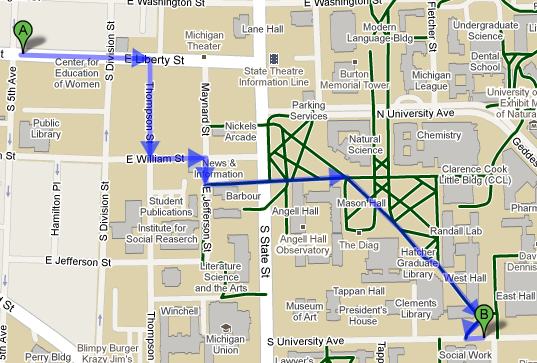
A route from the AnnArbor.com office to South University Avenue, via the Diag.
Google Maps
Google Maps has coverage of Ann Arbor's Central Campus that shows many of the non-motorized paths. As always, when you are biking across the Diag, use your bell to alert pedestrians that you are coming and walk your bike through the Engineering Arch.
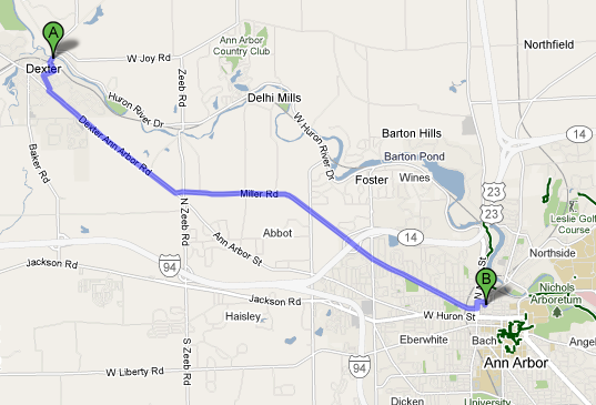
Google misses the favorite Huron River Drive routing to Dexter.
Google Maps
The route from Ann Arbor to Dexter suggested by Google Maps misses a cyclists favorite: the winding Huron River Drive; it prefers the shorter Miller Road routing.
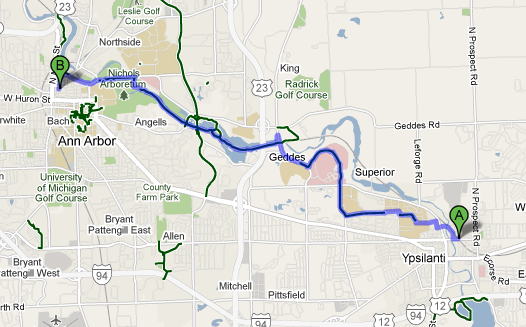
Ann Arbor to Ypsilanti routing follows the trails along the river.
Google Maps
Downtown Ann Arbor to Ypsilanti's Depot Town routing goes via trails along the Huron River, including parts of the Border to Border Trail that are not open to vehicles. This 10-mile route also would work well as a pedestrian path, better even than Google's walking directions.
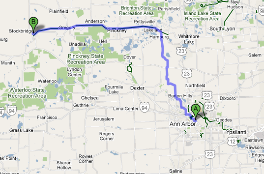
Google Maps picks up the Lakelands Trail State Park as its suggested bicycle routing to Stockbridge.
Google Maps
Lakelands Trail State Park is a linear park that runs for about 20 miles from Hamburg to Stockbridge in nearby Livingston County. The Google Maps bicycle routing selects this as part of the trail it puts you on to Stockbridge.
Other bicycle maps and routes
The Friends of the Border to Border Trail website has links to bicycle maps of the area online, including the eastern Washentaw segment from Washtenaw County and the Ann Arbor bike map maintained by the city.
Ann Arbor's getDowntown program maintains a collection of online bicycle maps.
Border To Border Eastern Segment printed maps (Ypsilanti & Ypsilanti Township) are currently available free of charge at Ypsilanti City Hall and at Ypsilanti Cycle on Michigan Avenue in downtown Ypsi.
Both MapMyRide and Bikely have collections of rider-submitted bike routes, often with notes and commentary about the route. Bikely's Ann Arbor to Detroit route picks up Hines Drive along the way.
The Ann Arbor Bicycle Touring Society has routes as long as 100 miles, if you find yourself itching to ride to Cabela's in Dundee or all the way to Danville in Ingham County.
Words of advice
Always wear your helmet, and check with someone who actually knows the route before you trust the first day of a new Google product on your bicycle.
Edward Vielmetti needs to put air in his tires before he rides his bike for AnnArbor.com. Contact him at edwardvielmetti@annarbor.com.Â
Comments
Andy Brush
Wed, Mar 10, 2010 : 11:31 a.m.
This is very cool and a nice addition. Good to know that they added non-motorized trails. The suggested bike route from my home near Allen School to downtown Ann Arbor looks a lot like the one I take daily. Except that it doesn't know the shortcut behind Tappan School. I think this will be helpful in the upcoming Commuter Challenge in May.