
Water, water everywhere: Huron River, rain, drought and severe weather maps
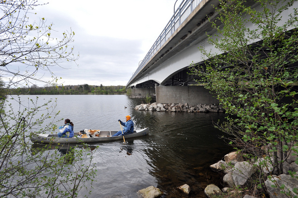
Maryanne Ried of Ann Arbor, left, and Scott Merrits of Ypsilanti make their way down the river gathering trash during the 17th annual Huron River Clean-up from Argo Dam to Gallup Park on April 17. The photo shows the stream with the gauge at about 12.5 feet, with a discharge rate of about 400 cfs; today's measurements have the stream up 1.5 feet from this level, with about triple the stream flow.
Mark Bialek for AnnArbor.com
Huron River
The USGS Waterwatch map of Michigan shows stream levels across the state. Recent rains across the southern tier of Michigan counties have sent stream levels well above average.
The Huron River stream gauge in Ann Arbor, which is located near Riverside Park just downstream from the Argo Dam, shows a current reading of 13.91 feet, which is above the action stage of 13.5 feet but below the flood level of 16 feet. At a 15-foot reading, parts of Island Park start to flood; the forecasts don't show that as likely.
The stream gauge also shows a current flow rate of 1290 cfs (cubic feet/sec). Derek LeRoy of the Huron River Fly Fishing Club has posted a guide to safe river wading levels for people who are fly fishing in the river. As always with guides like these, use your own judgement, and go with someone experienced if there's any question:
"700 cfs or greater - very high and fast water - wading is very difficult and dangerous.
600 to 700 cfs - you can expect higher then average water level and stream flow throughout the river. Still difficult wading conditions in the upper 600 cfs
500 to 600 cfs - most areas of the river will be wadable. Expect to wade on your tip toes in deeper sections. Some sections of the river will still be fast. Wade with caution.
400 to 500 cfs - I have found the best fishing conditions on the entire river is when the flow rate is 400 to 450 cfs.
300 to 400 cfs - Great wading conditions.
200 to 300 cfs - Great fishing in deep, protected holes. Some of the best Hex fishing seems to happen in the 200 to 250 cfs range.
199 or less - shallow water - consider wet wading."
Fast moving water can be treacherous, and when the water is dangerously high paddlers in canoes and kayaks can be swept to danger. Two stories from last summer, of an emergency rescue at the Zeeb Road bridge and of rescues near the Dexter-Huron Metropark and Island Park, illustrate the risks.
Precipitation maps
It rained yesterday, up to 3 inches in parts of Washtenaw County, according to National Weather Service radar estimates retrieved yesterday.
The Advanced Hydrologic Prediction Service maps of recent rain in Michigan are bright and colorful, and show how storms have tracked through the area over the last week.
Drought maps
If you're tracking the weather for agriculture, one of the things you are looking for is any sign of long term drought. Extended periods of dry weather affect crops and timberland and can cause dangerous fire conditions.
The Michigan drought map is compiled by the National Drought Mitigation Center in Lincoln, Nebraska. Last week's map shows normal conditions in the agricultural areas in Washtenaw and surrounding counties, and abnormally dry conditions north of Clare. The western Upper Peninsula is in "severe drought" status. Maps are updated weekly; a new one will be out tomorrow.
Hail, tornados, and wind storms
The National Weather Service does a daily storm report, tracking tornados, hail storms, and high wind situations that lead to property damage or worse.
A map of the storms of May 10 shows the severe weather that hit eastern Oklahoma and much of Kansas on Monday. Forty-two tornados were reported across the area, and there were 69 reports of hail storms, with 11 cases where the hail was more than 2 inches in diameter.
The NewsOK coverage of the deadly May 10 tornado outbreak is comprehensive. The Oklahoma Department of Emergency Management reported that more than 100 homes and 40 businesses were destroyed and more than 130 homes were damaged, and there is now a state of emergency for 56 Oklahoma counties.
Edward Vielmetti is the lead blogger for AnnArbor.com. Contact him at edwardvielmetti@annarbor.com.Â