
Live blogging: Updates on the coming snowstorm all day
I'll be hosting a live blog for snow updates this afternoon, with some notes on the progress of the storm and how it's affecting travel across the country.
10:00 p.m. Tuesday
Flightaware.com has 3,837 US flight cancellations already listed for Wednesday, including 228 departures and 226 arrivals from Detroit Metro Airport.
9:25 p.m. Tuesday
The view from the Shapiro Library webcam on the University of Michigan central campus. The camera can only take so many users, so if you get no live picture, you can wait patiently.
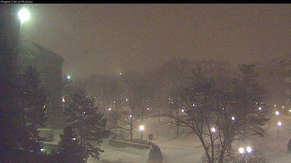
The view from the Shapiro Library to the University of Michigan Central Campus Diag.
University of Michigan
The I Opt cam looks out at North University and State Street from the Nickels Arcade. See it at http://www.iopt.com/image.jpg.
9:20 p.m. Tuesday
No service on AATA Route 33 tomorrow, since Eastern Michigan University is closed. Details via the @CatchTheRide twitter account.
8:15 p.m. Tuesday
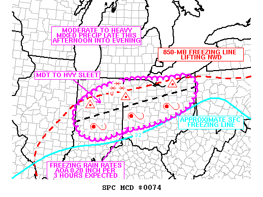
An update of the front map, which you can find on http://annarbor.com/weather in the "maps center". Note that the purple area, which shows mixed snow and rain and ice and sleet and other yucky weather, is well to the south of us.
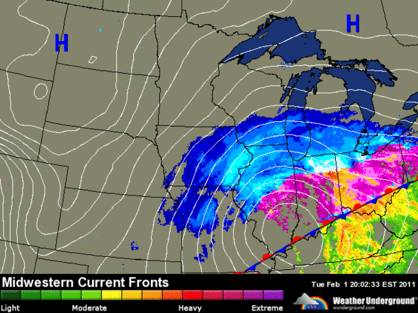
Weather map shows mixed rain and snow well to the south of Ann Arbor at 8:00 p.m. Tuesday.
AnnArbor.com weather, powered by Weather Underground
8:10 p.m. Tuesday
Techsmith up in Okemos is watching the snow with a live camera, and measuring progress against a giant snow spork. I am not making this up.
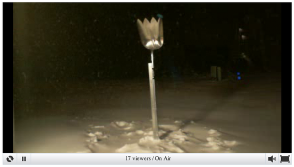
Via Techsmith
8:00 p.m. Tuesday
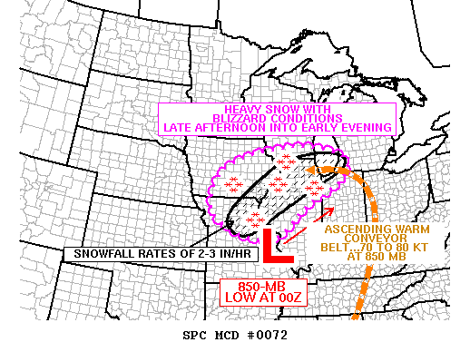
A new mesoscale forecast is out for Michigan. Mesoscale discussion 76 notes widespread blizzard forecast conditions over lower Michigan, with 1 inch per hour predicted in Washtenaw County and 2 to 3 inches per hour to the north of us.
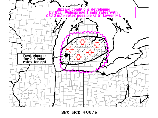
Mesoscale Discussion 76
Storm Prediction Center
7:50 p.m. Tuesday
The webcam at the corner of Seventh and Washington Street watches the pedestrian crossing sign at that corner. It's been 15 weeks, 5 days, and 9 hours since the sign was last hit by a car. Thanks to Wayne Eaker for the camera.
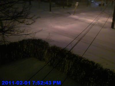
Courtesy Wayne Eaker, a2cam.com
6:25 p.m. Tuesday
Power outages across central Indiana, as seen by the Duke Energy outage map.
6:15 p.m. Tuesday
Ann Arbor Public Schools are called off for tomorrow, according to ‎Naomi Zikmund-Fisher; the Ann Arbor Public Schools cancellations page does not yet reflect that. I'm sure that it's because my kindergartener was sent home with instructions to flush an ice cube down the toilet. See the full list of school closings for Washtenaw County.
6:00 p.m. Tuesday
Mesoscale discussion #74 with a new map, still showing the ice and freezing rain staying to the south of Ann Arbor.
Mesoscale Discussion 74.
Storm Prediction Center
5:00 p.m. Tuesday
A last update before I blast off for dinner is Mesoscale discussion #72. The mesoscale discussion have awesome graphics and daunting text, part of which is snipped below:
Valid 012136Z - 020330Z
Heavy snow and blizzard conditions will overspread portions of the mid-Mississippi Valley region toward Lake Michigan, including the Chicago metro area, through late afternoon into the evening. The very powerful extratropical cyclone over the central continental United States continues shifting northeastward toward the Great Lakes region. The well-defined and ascending warm conveyor belt wrapping cyclonically around the low is transporting deep moisture from the Gulf of Mexico into the Ohio Valley and westward across the Midwest. To the north of the impinging dry slot over the mid-Mississippi Valley region. Heavy snow will continue shifting north-northeastward in the deformation zone of the cyclone across the discussion area into this evening.
Mesoscale Discussion #72.
Storm Prediction Center
24 hours of snow in 20 seconds is the NASA Image of the Day. Download it here: http://www.nnvl.noaa.gov/animations/high_quality/641_20110201-Snow.mp4
4:40 p.m. Tuesday
National Weather Service Detroit forecast, converted out of all uppercase.
A dangerous winter storm will track across the Ohio Valley tonight and Wednesday, spreading heavy snow and blizzard conditions into southeastern Michigan. Snow will become heavy tonight and persist into Wednesday morning, with snowfall rates reaching between 1 and 3 inches per hour. In response to this winter storm, very strong northeast winds will develop overnight and continue through Wednesday morning. Strong winds in excess of 35 mph will combine with the heavy snow to create blizzard conditions across all of southeastern Michigan. Significant blowing and drifting of snow will occur, helping to create whiteout conditions. Snowfall and wind gusts will decrease in intensity Wednesday afternoon with snow diminishing by the early evening. Storm total snow accumultions of between 7 and 12 inches will be possible across much of southeastnern Michigan, with 10 to 15 inches possible between teh I-69 and M-46 corridors. Those residing in or planning travel to this region are strongly encouraged to monitor the latest forecasts and conditions before attempting necessary travel tonight and Wednesday. If you must travel, prepare a winter survival kit to take with you.
4:35 p.m. Tuesday
Ignite Ann Arbor organizer Ryan Burns is outrunning the storm on Amtrak. "IT IS NOT SNOWING IN BATTLE CREEK. REPEAT. IT IS NOT SNOWING IN BATTLE CREEK. #snOMG"
Watch the WGN-TV live snow cam to see the snow hit Chicago; report from Jim Cantore are that it's currently coming down at an inch an hour in that city.
4:30 p.m. Tuesday
The University of Michigan campuses in Flint and Dearborn are closed tomorrow, according to the University Record. The Ann Arbor campus will be open, says the Record. The last snow closing at the University of Michigan was in 1978; read the Michigan Daily headline, "Rampaging blizzard rakes state; Nat'l Guard called out; 'U' closes".
The Center for Disease Control wants you to avoid carbon monoxide poisoning.
4:20 p.m. Tuesday
Chicago Skyline from Navy Pier. Photo from Micki Maynard; thanks to Ben Connor Barrie of Damn Arbor. Ben and the Damn Arbor crew have been documenting the Ann Arbor reaction to the storm: "Meijer and Kroger were out of milk so we bought Bells Winter White."
4:15 p.m. Tuesday
From the Ohio Department of Transportation, Toledo twitter feed, translated slightly: "Know before you go. Crews continue to plow, treat routes. Light snow to increase intensity thru pm. Ice possible south of US 6." US-6 near Toledo runs through Bowling Green, Ohio, about 70 miles south of Ann Arbor.
4:10 p.m. Tuesday
Current 4:00 p.m. weather map from the AnnArbor.com weather page, which is powered by Weather Underground. Note the purple, which is a mix of rain, snow, sleet, and ice; let's hope we don't get that purple here.
Via Weather Underground
4:05 pm Tuesday
Due to the snow/blizzard that will be arriving tonight, Summers-Knoll School will be closed tomorrow, Wednesday, February 2nd. We wish everyone a warm and safe day. Have fun in the snow! (Via Karen Bayoneto, office manager.)
4:00 pm Tuesday
Also from Chicago is the CrisisCamp Chicago Blizzard Feb2011 Watch, with resources and social media tools for a team tracking response to the blizzard from all over the Midwest. They are mapping the storm and its response at http://chicagosnow.crowdmap.com/; at 4:00 pm Eastern (3:00 pm Central) there's one dot on the map, someone wanting to share a shovel.
3:50 pm Tuesday
Here's how the Chicago Tribune covers the snowstorm, with Tom Skilling and his colleagues in the WGN Weather Center.
We have 92 forecasts off of 7 different computer models - models from Canada, the NWS, Europe, U.S. Navy, the University of Illinois - it’s an amazing array of data to look at. We were commenting in the office that we used to have one long-range model and one short-range model. If they were the outliers for the day and didn’t have it (the right information), you went down with the model forecast.
3:45 pm Tuesday
Weather.com has a nice set of blizzard and ice storm reports for this storm.
3:35 pm Tuesday
At 2:00 p.m., the National Weather Service Grand Rapids office put together a weather webinar (PDF, about 1.2 megabytes). It includes some of the imagery seen below, all put together in a convenient one stop package.
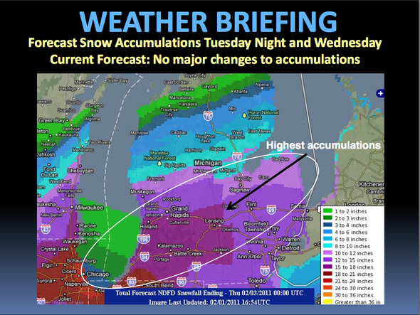
National Weather Service, Grand Rapids MI
3:20 pm Tuesday
Wayne State University: Evening classes are CANCELED tonight and the university is CLOSED tomorrow, Feb. 2. Via the @WayneState twitter account.
3:12 pm Tuesday
A storm image from NOAA's Environmental Visualization Lab, via the GOES East satellite. Details at http://nnvl.noaa.gov/MediaDetail.php?MediaID=640&MediaTypeID=1
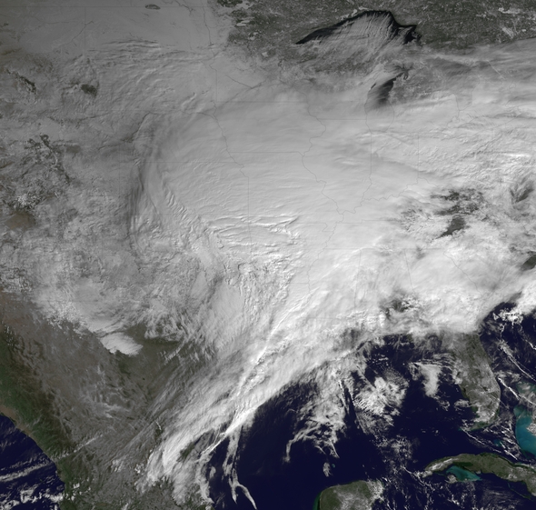
A large swath of blizzard warnings, winter storm warnings, freezing rain advisories, winter weather advisories and winter storm watches are in effect, stretching from new Mexico and the Southern Plains northeastward through the Midwest and into the upper Mid-Atlantic and New England. This image is from GOES East at 1545Z.
Courtesy NOAA
2:55 pm Tuesday
Eastern Michigan University is closing at 5 pm tonight.
Due to the predicted extreme weather event and blizzard warning beginning at 7 p.m. through tomorrow for our region, Eastern Michigan University President Susan Martin has announced the cancellation of all evening classes on Tuesday, beginning at 5 p.m., and all day and evening classes on Wednesday. This includes all planned campus activities, lectures and events, with the exception of the Men's Basketball Game at 7 p.m. Wednesday at the Convocation Center, which will be played as scheduled.
Another cancellation, the Ann Arbor City Planning Commission.
Due to impending winter storm conditions, the City Planning Commission meeting for Tuesday, February 1, 2011 has been cancelled. This Planning Commission meeting and its agenda have been rescheduled to Tuesday, February 8, 2011 at 7 pm in the County Board Meeting Room, Washtenaw County Administration Building, 220 N. Main Street. The agenda will include a public hearing on the proposed Parks and Recreation Open Space Plan.
2:30 pm Tuesday
Whenever you are looking at weather forecasts there are curious boundary effects where one forecasting area stops and the next one starts. The question for this storm in my mind is where is there going to be ice and where is there going to be snow. The Ohio forecasts tend towards ice, and the Michigan forecasts tend towards snow.
Here's a 1 a.m. forecast showing the furthest north ice boundary I can locate, with ice in southern Monroe and southeastern Lenawee counties but no ice in Washtenaw. More details from the National Weather Service: http://www.weather.gov/forecasts/wfo/sectors/dtxWeek.php#tabs.
This National Weather Service forecast shows a chance for ice to the south of Ann Arbor at 1:00 am Wednesday.
National Weather Service
2:15 pm Tuesday
The Flightaware cancellation count is up to 6,519 at 2:11 p.m., from 6,322 an hour ago. 3,087 flights have been cancelled for tomorrow, and 79 flights on Thursday are already nixed.
2:00 pm Tuesday
The National Weather Service Storm Prediction Center has issued Mesoscale Discussion 68, discussing the near term impact of the storm as it crosses Indiana and Ohio leaving freezing rain in its wake.
The technical discussion, translated from the upper case with some abbreviations expanded but not otherwise translated into English:
A powerful extratropical cyclone continues to mature over the central continental United States, with a well-defined and intense warm conveyor belt in the eastern semicircle of the cyclone. The 10:00 a.m EST (15:00 GMT) run of the RUC model indicates an 850 mb jet max with core winds of 70 knots over portions of the lower Ohio Valley and mid-South. This is supporting strong northward transport of deep-layer moisture, with (AMSU/SSMI) total precipitable water product indicating a flux of (PWAT) values around 1.5 inches nosing into the lower Mississippi Valley region. Deep-layer ascent associated with the warm conveyor belt rising atop the cold air mass entrenched across the Ohio Valley region will be augmented by intense upper-level divergence expected to result from a coupled jet streak structure later this afternoon. As precipitation falls into a near-surface sub-freezing layer at last 60 statute miles north of the Ohio River, mixed precipitation types are expected this afternoon.
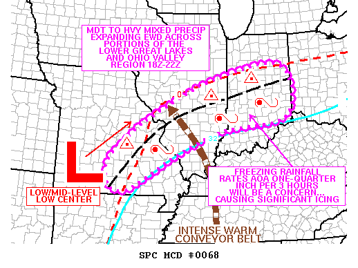
Mesoscale Discussion 68, http://www.spc.noaa.gov/products/md/mcd0068.gif
Storm Prediction Center, National Weather Service
1:55 pm Tuesday
FEMA, the Federal Emergency Management Agency, keeps a list of state emergency management offices using Twitter; see that list at http://twitter.com/#!/fema/state-em-offices.
Among those agencies is the Michigan State Police, Emergency Management and Homeland Security Division. Follow them on Twitter as @MichEMHS.
1:40 pm Tuesday
If you are watching hash tags on Twitter, the favorites at the moment seem to be #snomg and #snowday. The National Post has collected a list of ridiculous snowstorm nicknames, collecting winners like Snowtorious B.I.G., precipaclysm, and Oblizzarate.
1:24 pm Tuesday
Snow cancellations are coming in for Wednesday. My inbox has copies of a few.
The Ann Arbor YMCA has cancelled classes and ChildWatch for Wednesday, but will be open from 10:00 a.m. to 10:00 p.m. See details: http://annarborymca.org/news/class-cancellations-and-hours-operation-wed-february-2-2011.php.
The University of Michigan Exhibit Museum announced that “Our Water, Our Future: A Local Panel,” scheduled for Wednesday, February 2 at 7 pm, has been cancelled. Details: http://www.lsa.umich.edu/exhibitmuseum/
1:20 pm Tuesday
No snowstorm would be complete without a mention of Heikki Lunta, the Finnish snow god who originated in Michigan's Upper Peninsula. Lyrics to the Heikki Lunta songs include this snow dance, from the Ishpeming based band Da Yoopers from their album Yoopy do Wah:
Heikki put his snowshoes on and grabbed a can of beer
Put on his giant partridge wings and antlers from a deer
Then he grabbed a cedar branch and danced around the yard
Everybody said they never seen it snow so hard
1:10 pm Tuesday
The Flightaware list of cancelled flights is at 6,322, up from 6,019 at 12:16 pm. 126 outbound flights from Detroit Metro Airport are cancelled, and 146 inbound flights are cancelled.
1:00 pm Tuesday
Oklahoma has been hard hit by the blizzard. News on 6 reports that the Oklahoma National Guard has been called out to rescue stranded motorists.
12:45 pm Tuesday
The Weather Underground is the source for the maps on the AnnArbor.com weather page, http://annarbor.com/weather. Meteorologist Jeff Masters is tracking this storm; here's a piece of his morning weather blog, Great Blizzard Pounds Midwest:
Many major cities will likely receive over 12 inches of snow from the Great Blizzard of February 2011, including Kansas City, St. Louis, Detroit, and Boston. Perhaps of greater concern is the potential for a major ice storm along a swath from Northwest Oklahoma to Massachusetts. Widespread freezing rain is expected to bring over 1/4" of ice to many major cities, including Indianapolis, Columbus, Cleveland, Pittsburgh, and New York City. Some regions could see up to an inch of ice, and widespread power outages due to toppled power lines are likely for millions of people. Damages exceeding $1 billions are possible from this ice storm.
12:20 pm. Tuesday
Flightaware is tracking airport cancellations, and it shows 6,019 cancelled flights as of Tuesday at 12:16 p.m. Full details at http://flightaware.com/live/cancelled.
Hardest hit are airline hubs in the path of the storm. Dallas/Fort Worth (KDFW), Chicago O'Hare (KORD), LaGuardia (KLGA) and Newark Liberty (KEWR) airports all show more than 300 departing flights cancelled.
Detroit Metro Airport is currently showing 114 cancelled outbound flights and 144 cancelled inbound flights, and the list of cancelled flights on Delta Airlines has grown to over 400 flights.
12:15 pm. Tuesday
Waves on Lake Michigan are forecast to be over 10 feet near the Wisconsin - Illinois border this evening, according to the Great Lakes Coastal Forecasting Service. Full details at http://www.glerl.noaa.gov/res/glcfs/.
For Chicago area weather, see the Chicago Breaking News "Blizzard Blog", which reports that over 1,100 flights at O'Hare Airport have been cancelled in anticipation of widespread storm disruption to the air travel system.
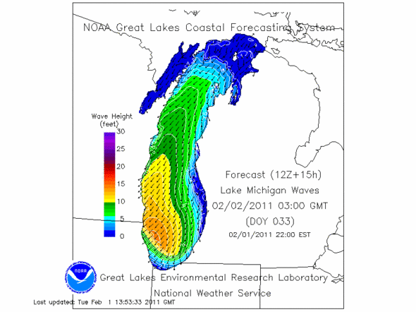
Forecast waves for Lake Michigan, 10:00 p.m. EST on Tuesday.
Great Lakes Coastal Forecasting Service
Noon Tuesday
Technical forecast from the National Weather Service Detroit, from 4:53 a.m, edited lightly for clarity. The full detail at http://www.crh.noaa.gov/dtx/display_probtxt.php?file=afdblog
Models have deviated little over the past several days with the track and snow amounts expected from this winter storm and forecast confidence is high. Upper level energy dropping out of the desert southwest will eject out of a deep upper trough over the western US and lift up towards the southern Great Lakes tonight. Surface low pressure will track just east of it, lifting up into Ohio by late tonight. A good amount of moisture still looks to be available to work with deep layer lift from fgen forcing, a deep layer mid-level instability, and coupled upper jet structure. This will provide steady snowfall, intense at times from late evening through overnight. Will start to lose upper jet and fgen forcing Wednesday morning, however we will then gain strong isentropic ascent on the backside of the system. This will allow snow to continue through much of the day on Wednesday, though at a lighter intensity by late afternoon and evening.
11:45 am. Tuesday
The Hydrometeorlogical Prediction Center notes the chance of the accumulation of at least 0.01 inch of ice today. Note that the probabilities increase as you go south from the area, and that we are right on the fringe of where there is an outside chance of ice.
More at http://www.hpc.ncep.noaa.gov/wwd/winter_wx.shtml
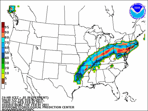
Hydrometeoroligical Prediction Center, National Weather Service
Comments
Jeff Renner
Wed, Feb 2, 2011 : 2:16 a.m.
U of M diag cam <a href="http://shapiro.cam.lib.umich.edu/view/index.shtml" rel='nofollow'>http://shapiro.cam.lib.umich.edu/view/index.shtml</a>. I have friends around the globe who check this out. I gotta love the internet. Almost as good as the organization of the Egyptian protests. My wife, as a U of M Hospital employee, is "expected" to make it into work, and since she's the boss, she needs to provide a good example. So I posted her need on a hobby group (Ann Arbor Brewers Guild) and got an answer in less than an hour. So she has a ride in a 4WD into work tomorrow. Hooray!
Kai Petainen
Wed, Feb 2, 2011 : 1:24 a.m.
cool coverage!
PittsfieldTwp
Wed, Feb 2, 2011 : 1:01 a.m.
Saline schools finally made it official <a href="http://www.salineschools.com/" rel='nofollow'>http://www.salineschools.com/</a>
genericreg
Wed, Feb 2, 2011 : 12:26 a.m.
Edward always helpful and research. Best part of site.
Sarah
Tue, Feb 1, 2011 : 9:49 p.m.
Oh wow, that storm picture over North America is beautiful. Thanks, Ed!!
Ben Connor Barrie
Tue, Feb 1, 2011 : 9:13 p.m.
Chicago skyline from Navy Pier: <a href="http://plixi.com/p/74072605" rel='nofollow'>http://plixi.com/p/74072605</a>
Macabre Sunset
Tue, Feb 1, 2011 : 7:07 p.m.
Based on the latest NWS update (0Z 2/2 to 0Z 2/3), they seem to be settling in on around 10-11 inches for the immediate area. But I still get the sense it could vary widely based on a shift on only a few miles. The NWS web site is getting pounded. It's almost as slow as pluck right now.
Guinea Pig in a Tophat
Tue, Feb 1, 2011 : 6:05 p.m.
This is cool! Thanks Ed!
Top Cat
Tue, Feb 1, 2011 : 6 p.m.
My sense is that for Mr. Veilmetti, tracking this storm and reporting on it in such a manner is a nerdish labor of love and that he is enjoying this immensely.
Bob Martel
Tue, Feb 1, 2011 : 6 p.m.
Agreed, very cool stuff! I'm glad I don't have to be out in it and am doubly thankful for the whole house generator!
PittsfieldTwp
Tue, Feb 1, 2011 : 5:40 p.m.
So does the ice probability increase equate a snow fall amount decrease? Good stuff.