
Map libraries and archives tell stories of how things would have been
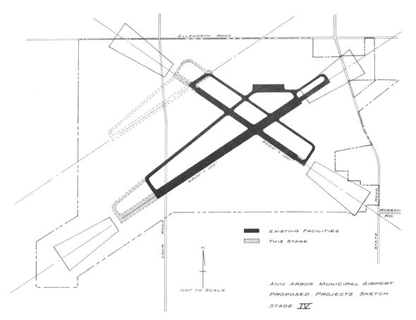
This map shows stage 4 in an Ann Arbor Municipal Airport master plan from 1969, scanned in from the archives of the Airport Advisory Commission held at the Ann Arbor District Library. This plan would have extended a runway across Lohr Road, which would have been closed. Runway expansion was stopped after years of opposition. Accounts of it fill a linear foot of civic records, engineering reports, and meeting minutes.
Ann Arbor Municipal Airport Master Plan, 1969
Here are some map libraries to look through, ranging from up to the minute current digital data to historic maps found only on paper.
City of Ann Arbor
The City of Ann Arbor data archive has maps, almost all of which are in very easy-to-use formats. My February roundup of available maps shows samples of boundary maps, permit maps, and school district maps available.
Washtenaw County
The Washtenaw County Geographical Information Service maintains parcel maps and property data, plus enough other map layers that you would need to do county-level land use analysis, planning, and assessment tasks. The layers include aerial photos. This collection is notable because the county will print out a very high quality rendering of whatever map you are looking to put together for a modest fee.
State of Michigan
The State of Michigan's Michigan Geographic Data Library is a catalog of the geographic data that the state has for access. It's organized thematically, so that you can find all of the geology maps; it's also organized geographically, so you can look at all of the maps that cover Washtenaw County.
The state's map collection is less accessible than the city's map collection, because all of the files are stored in "shape file" format, a very precise format which is only supported by a handful of high-end mapping programs. This is in contrast to the city's support for KML, an open file format promoted by Google that can be loaded into a variety of online mapping tools.
University of Michigan Map Library
The University of Michigan's Map Library is located on the eighth floor of the Hatcher Graduate Library on Central Campus. There is an enormous collection of paper maps in the collection, with a good number of local historical maps, as well as extensive world-wide holdings. The last time I was up there I found historical maps of the Metroparks system, including canoeing guides for the Huron River dating to the 1940s through the present day.
For digital and custom maps, schedule some time with the SAND (Spatial and Numeric Data Services) librarians, who have offices on the second floor of Hatcher and some seasonal office hours on North Campus.
Both the Clements Library and the Bentley Library have historic maps in their collections. The Map Division of the Clements has about 30,000 items and claims to hold "virtually every printed map relating to the United States before 1820, either in original copy or photostat." The Bentley's collection includes the Michigan Historical Collections, which has more than 10,000 maps covering Michigan history. To research either collection, you'll want to come prepared to speak to an archivist about your research goals; with any archives there are substantial limits to the use of original materials and how you must handle them.
Other statewide collections
Both Michigan State University's Map Library and Eastern Michigan University's Map Library have substantial collections, neither of which I have explored. The Detroit Public Library's map collection includes 150,000 sheet maps, featuring special collections of topographic maps covering many European countries including the 1871 German Empire and the Austro-Hungarian Empire.
Ann Arbor District Library
The maps room on the second floor of the main branch of the Ann Arbor District Library has atlases and local maps, plus a set of printed Sanborn Fire Insurance Maps that show local building history.
The biggest untapped source of local maps is the Ann Arbor municipal archives, also in the reference area downtown. Hiding among municipal planning documents and annual committee reports from the 1960s to date are all manner of maps, illustrating projects that might have been or that never should have even been considered. These are indexed only by the organization producing them, so you'll have to sift through hundreds of pages of committee reports to find the one page of proposed road maps, or the 1960s era airport master plans, that make the exercise worthwhile.
Edward Vielmetti reads maps for AnnArbor.com.
Comments
Wguru
Thu, May 20, 2010 : 3:46 p.m.
The current version of Google Earth (both free and Pro) has an option for Historical Imagery, which for the Ann Arbor area currently includes about 9 sets of images going back to 1992. You also can add your own historical imagery to Google Earth and compare how areas have changed over the years. (Learn how at WCC's classes on using Google Earth.) The State needs to step it up and release "shape file" maps in KML format as well... like Ann Arbor, Washtenaw County, and many federal sites have done.