
Pittsfield Township in maps, east of US-23, north of I-94
Four county governments are looking at a new taxing authority to develop the Washtenaw Avenue corridor, in part because there are so many government units which each oversee a small slice of Washtenaw that it's hard to have one cohesive plan for the area.
If you live in Ann Arbor and you're heading to Ypsilanti, it's not always clear where the boundaries are. More to the point, it's not clear to anyone once you go past US-23 where Ann Arbor ends and where Ypsilanti begins.
Here's an exploration, done mostly in maps, of the section of Pittsfield Township that's located between Ann Arbor and Ypsilanti. You'll see some of the various bits of confusion reflected in map form that explain why the space between the two cities need to be treated as a place of its own.
Basic information and street maps
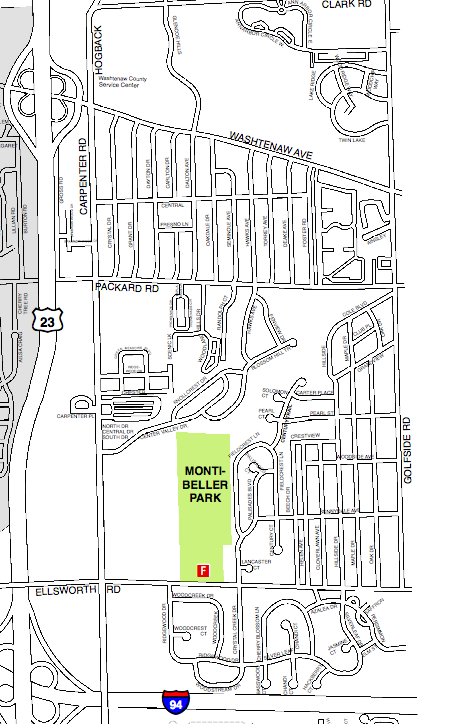
Courtesy Pittsfield Charter Township
Our area of focus is Pittsfield Township east of Ann Arbor and US-23, south of Ann Arbor Township and Clark Road, west of Ypsilanti Township and Golfside Road, and north of I-94. Ellsworth Road is near the southern boundary of the area of interest.
All locations described have Pittsfield Township taxes and Ann Arbor schools; some have Ann Arbor addresses, and others have Ypsilanti addresses. Some of the water in this part of the world drains north to the Huron River; other water drains run south to Paint Creek.
Links
- Pittsfield Charter Township
- Pittsfield Street Map, PDF
- Pittsfield Township Historical Society
- Montibeller Park is a 52-acre preserve, including a 17-acre wood sheltering 1.25 miles of Paint Creek, a tributary of Stony Creek.
Transit and transportation
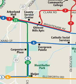
Courtesy Ann Arbor Transportation Authority
- Route 4, Washtenaw bus
- Route 5, Packard bus
- Route 6, Ellsworth bus
- Route 7, South Main, East bus
- Route 22, North South Connector bus
Mailing addresses in three zip codes
If you try to make sense of the area through the zip code map, you get a mish mosh that doesn't make any sense. Parts of the area are served by the Ypsilanti post office, and other parts are served by two different Ann Arbor zip codes. The upper corner shows the Hogback Officenter, an office park with a 48105 zip code. If you oversimplify, you get the conclusion that single family homes are in an Ann Arbor zip code and apartment complexes are in an Ypsilanti zip code.
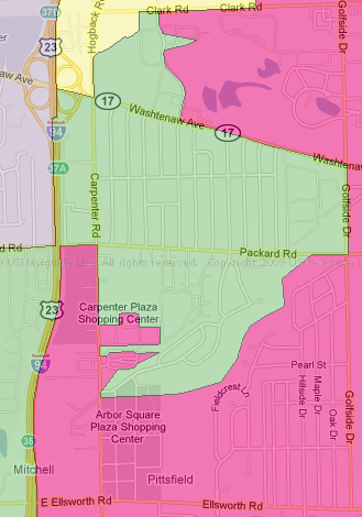
Zip Code information on this map as of January, 2010. Source: USNaviguide LLC.
Links:
- US Naviguide LLC has zip code mapping.
- Hogback Officenter is managed by Flying Dutchman Management
School systems
The entire area is served by the Ann Arbor Public Schools. The district map shown indicates one neighborhood school, Carpenter Elementary School, where kids who live nearby can walk to. Other students are bused to Angell, Burns Park, Pittsfield or Mitchell elementary schools.
The Ann Arbor Public Schools borders the Ypsilanti Public School District at Golfside, and Ypsilanti High School is relatively close by. Ypsilanti is a "schools of choice" district.
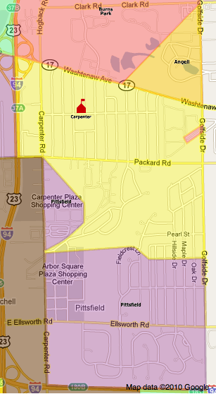
Note that depending on the street, students on one side of a road may be assigned to a different school than students on another side of the street. Check detailed records available at the Ann Arbor Public Schools for school assignments.
Boundaries provided by Ann Arbor Public Schools.
Voting maps
Voting precinct maps here are actually a bit more sane than the other maps, since they describe continguous areas. Four Pittsfield precincts are in the area in question, here described north to south.
Pittsfield Precinct 4 is between Clark and Washtenaw Roads and votes on Packard at Catholic Social Services. Students in Precinct 4 are all bused to Ann Arbor schools that are located near the center of Ann Arbor, either Burns Park or Angell. It is notable that the polling place is located on AATA Route 5, which does not connect directly to any of the AATA routes that serve the precinct area; this makes it all that much harder for voters who are using public transportation to get to the polls by bus.
Pittsfield Precinct 2 is between Washtenaw and Packard and votes at Carpenter School, which is located in the precinct area. Many students in the precinct can walk to the school.
Pittsfiled Precinct 11 is south of Packard, and north of the old railroad grade, bounded by Ellsworth Road at the south. Most of the students in the precinct would go to Carpenter School, but residents of the Coachville Gardens trailer park are bused to nearby Pittsfield School.
Pittsfield Precinct 3 is south of the old railroad grade and north of the freeway. Students are split between Carpenter and Pittsfield.
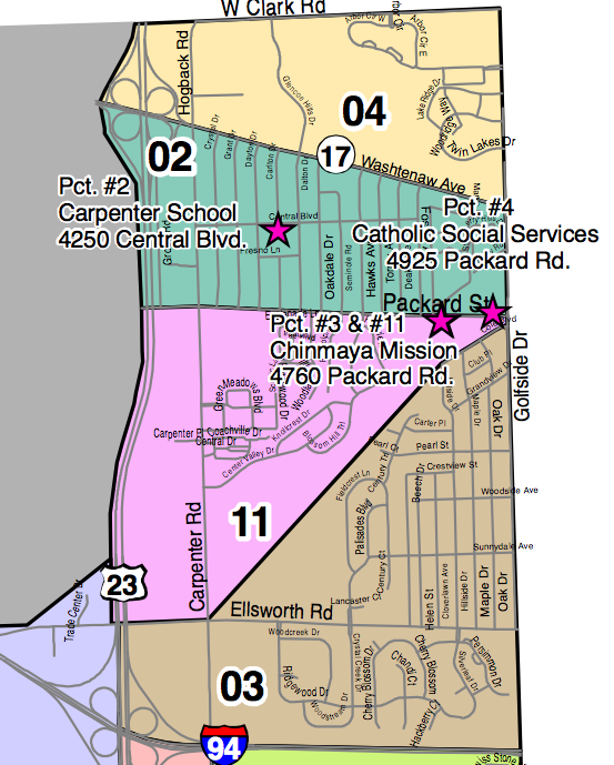
Precinct boundary maps for Pittsfield Township.
Courtesy Pittsfield Charter Township
Links
Historic maps
The layout of the roads through this area has not always been the same. The 1874 map shows a railroad running along a grade that is now a power line bisecting the township. The line, known by a variety of names depending on which organization plucked it out of bankruptcy last, ran from Ypsilanti to near Hillsdale, and was eventually absorbed into the New York Central system before being shut down in the area in question. The grade is still visible and in use as a power line corridor.
Old maps show a "Carpenter's Corners" name at the corner of Carpenter and Packard; I haven't found a comprehensive narrative that talks about that place and how it has evolved over time.
Links
- Historical plat maps, Pittsfield Township
- Lifelines, Grace Shackman, Community Observer, 2003; discusses the evolution of the area railroad system.
- Map: Detroit, Hillsdale and Southwestern, 1916, MichiganRailroads.com.
- Ypsilanti Gleanings, 2004. Or have you ever heard the story about the little village just West of Ypsilanti situated near the intersection of what is now Packard and Carpenter Roads. This area was farmed by, I believe two related people, possibly brothers, named Carpenter in the latter part of the 1800's. This area was known as Carpenter's Corners and was a very small village with its own cemetery. Yesterdays on Yost Mike Gould, originally for the Ann Arbor Observer. Before the US 23 - Washtenaw interchange was built, the woods extended from the old road behind our house all the way to Carpenter Road. Straight back from our house, across the field and maybe 30 feet into the trees, was a low spot that filled with water every spring.
Edward Vielmetti gets lost close to home for AnnArbor.com. Send him your favorite unpublished maps of the area at edwardvielmetti@annarbor.com
Comments
Beth
Fri, Sep 24, 2010 : 12:31 p.m.
There are other similarly weird areas of Pittsfield as well. We live south of 94 - Pittsfield Twp. taxes, Ann Arbor Schools, Ypsilanti mailing address. There are several neighborhoods in that area, and each is bused to a different AA school. Further west, the mailing address changes to Ann Arbor, and then the school district changes to Saline. It's always seemed odd to me that the mailing address for all of us isn't "Pittsfield Township". Does anyone know why it isn't? It causes a lot of confusion, having people see our address and having to explain that we don't actually live in Ypsi - my oldest got very upset in K when his teacher kept insisting he lived in Ypsi as part of a Social Studies project, and he knew we didn't! I can imagine those who feel they're a part of Saline but have an Ann Arbor address might have similar problems.
spm
Fri, Sep 24, 2010 : 6:51 a.m.
I remember moving to the subdivision off of Golfside south of Packard when I was a kid. I went from living in Ypsilanti, but going to Willow Run schools to living in Ypsilanti, but going to Ann Arbor schools. I always wondered why Ypsilanti had so many different school districts for being a relatively small town?
InsideTheHall
Fri, Sep 24, 2010 : 1:12 a.m.
The ol Pittsfield motto, "From Meijer to shining Meijer"
indigonation
Thu, Sep 23, 2010 : 10:07 p.m.
Must be a slow news day. *Yawn*
Duane Collicott
Thu, Sep 23, 2010 : 8:50 p.m.
It's interesting to see how the path of old rail lines still define property and visual features of the land, even long after they have been abandoned and the property sold. I believe the intersection of that line and I-94 was one of the last, if not the last, crossing of a railroad and an Interstate.
ronaldduck
Thu, Sep 23, 2010 : 8:18 p.m.
Don't forget Ypsilanti Township. The strech from Golfside east to the Ypsilanti city line is in Ypsilanti twp. and it's almost as long as the strech in Pittsfield twp.
Forever27
Thu, Sep 23, 2010 : 2:56 p.m.
@Matt, thanks for that link. Those are some great shots of the old rail line.
Vivienne Armentrout
Thu, Sep 23, 2010 : 11:52 a.m.
A valuable story and a great display of resources for describing an area. Imagine moving into a house somewhere in this area and having to sort all of this out. I wonder how many people living there describe themselves to others as living in "Ann Arbor" or "Ypsilanti". I wondered in looking at the map where the county commissioner district lines were drawn and I find that all of the area is in District 7 (http://gisapp1.ewashtenaw.org/webmaps/boc_map.htm), which is the entire part of Pittsfield Township that was not annexed into the City of Ann Arbor (it is not clear from the county's district map whether there are still any township islands in District 9). At least one source of confusion eliminated. (In comparison to Scio Township, which is represented in part by 5 different commissioners.) One aspect of this map is the location of the County Service Center on Hogback, in Pittsfield Township. This includes the jail, the sheriff's office, and District Court 14A. Under the direction of Sheriff Dan Minzey, the county did not provide any police protection for the service center (though their offices were right there), taking the position that it was Pittsfield Township's responsibility to police the center since it was located in Pittsfield Township. The township has its own police force and was reluctant to commit officers to this job. The standoff led to at least one incident in which an altercation in one part of the center was not immediately addressed by either police force. I wonder what the current Sheriff's position on this question is. (And the current township board's position.)
Matt Callow
Thu, Sep 23, 2010 : 11:26 a.m.
Geoff Foster has a series of photos following the route of the old railroad grade: http://www.flickr.com/photos/82716747@N00/sets/72157594313411922/
pvitaly
Thu, Sep 23, 2010 : 11:21 a.m.
I just bought a house in pittsfield, the block that goes from carpenter to golfside, packard to washtenaw. I was thinking a week ago how weird the pittsfield political boundary is.