
It's almost spring: predicting flooding on the Huron River
In the spring, the snow melts and low lying parts of the Huron River valley flood. This happens pretty much every year. And while the river is not at flood stages now, there are some parts of the low lying areas that are inundated.
Here's a satellite view roundup of what is going on with the river and some links to sources for predictions of flooding. It doesn't include any muddy sneakers reports.
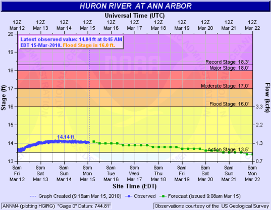
Predictions for river levels in Ann Arbor from the National Weather Service.
National Weather Service
The National Weather Service gauge in Ann Arbor shows flood stages for the river in the area. At the 15-foot level, flooding starts in Island Park, Riverside Park and Fuller Park, all in Ann Arbor; at 16 feet, the dirt parking lot at Riverside Park floods. The river's most recent high water mark was at 15.95 feet on March 18, 1982, and the recorded high flood stage was a record flood of March 14, 1918.
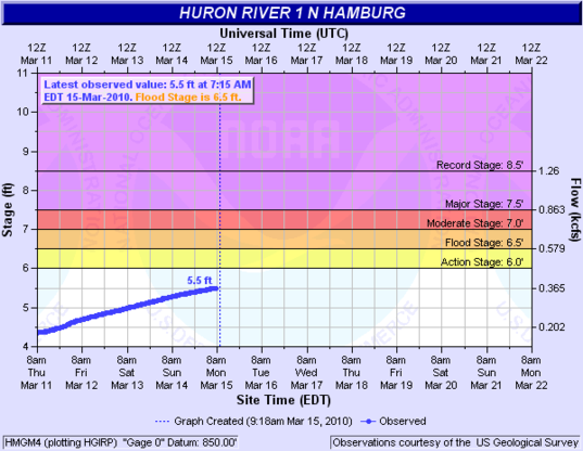
River levels continue to rise on the Huron upstream from Ann Arbor in Hamburg Township on Ore Lake.
National Weather Service
Upstream from Ann Arbor, the Huron River in Hamburg Township is also rising. On March 12, 2009, river levels hit 7.39 feet, causing flooding in homes near Ore Lake; the lake had flooded the year before as well.
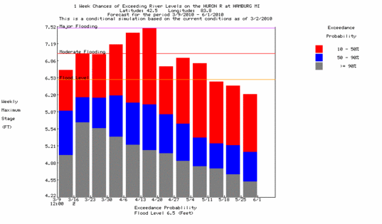
Flooding probabilities for the coming weeks in Hamburg Township
National Weather Service
This National Weather Service chart shows predictions of the high water mark on the Huron River in Hamburg. The top of the red bar represents a 10 percent chance of the river reaching that level; the top of the blue bar is the median predicted time.
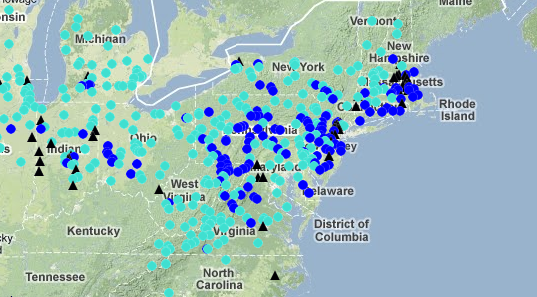
WaterWatch shows clearly the flooding in the northeast.
National Weather Service
The National Weather Service WaterWatch product shows flood stage conditions across the country; flood severity runs light blue to dark blue to black. The current snapshot shows clearly the widespread impact of the severe storms across the northeast, which killed 6 and caused 500,000 to lose power. (New York Times story).
Edward Vielmetti luckily does not own a home in a floodplain. Contact him at edwardvielmetti@annarbor.com.Â
Comments
Wystan Stevens
Tue, Mar 16, 2010 : 6:39 a.m.
Ann Arbor used to have several elevation benchmark disks, placed strategically around town. These were brass, maybe four inches in diameter, and incised with data. One was on an outside wall of the old Washtenaw County Courthouse, but probably ended up in a landfill when that landmark perished. Another was on the outside south wall of the old U-M Library stacks wing, which got torn down in 1966 to facilitate new construction. I haven't checked lately, but in past years I have noticed one that was set in concrete, level with the ground, at the SE corner of E. William and Thompson, and another at the corner of Seventh and Madison. There probably are others.
water
Mon, Mar 15, 2010 : 2:56 p.m.
Here is the USGS link for the Wall Street gauge in Ann Arbor. http://waterdata.usgs.gov/nwis/uv?cb_00060=on&cb_00065=on&format=gif_default&period=7&site_no=04174500 Here you can see the actual river height, historical data, and the erratic bumps from Argo Dam.
Andrew Thomas
Mon, Mar 15, 2010 : 2:53 p.m.
Can someone tell me what it means that flood stage is 16 feet? Where and how is this measured? Based on my experience kayaking on the Huron, it isn't anywhere near this deep, except maybe right behind one of the dams.
Epengar
Mon, Mar 15, 2010 : 1:39 p.m.
While it's normal for the Huron to rise and fall seasonally, it floods more often and higher now because of all the construction in the watershed. Rainfall hits impervious surfaces like roofs and pavements, and instead of soaking down into the ground, it gets immediately channeled into storm drains, and from there into local streams and the river. The Huron River Watershed Council and the Washtenaw County Water Commissioner's office both have information on things residents can do to reduce this kind of flash-flooding while also improving their own property. http://www.hrwc.org/take-action/capture-rain/ http://www.ewashtenaw.org/government/drain_commissioner/dc_webWaterQuality I've volunteered with the Watershed Council, they run a lot of fun, family-friendly programs that promote environmental health and the status of the river. People in Ann Arbor tend to think of the Huron as not very sanitary, but it's in a better state now than it was for many years.