
Sunday's storm: Snow and non-snow maps from NOHRSC
The Sunday snowstorm dumped 8 to 9 inches of snow around the Ann Arbor area. Forecasts from the day before had predicted a 50 percent chance of getting 0.25 inches of ice, but the storm track ended up giving the immediate area mostly snow, and the ice went to the south of us.
The National Operational Hydrologic Remote Sensing Center, better known as NOHRSC, puts together daily maps of snowfall, snow melt, and non-snow precipitation. The maps help answer the question of what fell where, and whether it came down as fluffy snow or a thick coat of ice.
Snow and not snow
The NOHRSC maps show snowfall estimates measured in water equivalents. The actual snowfall isn't recorded, just how much water is contained in the precipitation. In a typical snowstorm, you'll see about 10 inches of snow for an inch of equivalent rain, but that varies widely depending on how cold the atmosphere is where snow flakes form.
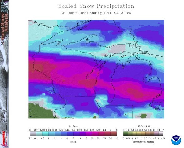
24 hours of snow precipitation across the northern Great Lakes, measured as equivalent rainfall.
NOHRSC
At least as interesting is the non-snow precipitation. This may come down as rain or as freezing ice, and the NOHRSC analysis doesn't measure ice as such. Note the abrupt transition from mostly snow to mostly non-snow, with the Washtenaw - Monroe county boundary line marking the point where snow tapers off.
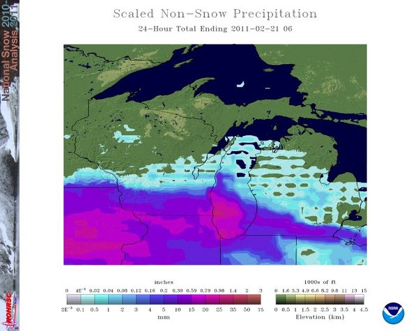
24 hours of non-snow precipitation across the Great Lakes.
NOHRSC
Impact of ice storms to the south
The DTE Energy power outage map shows only scattered individual power outages in the county, with fewer than 10 outages mapped in Bridgewater and Saline Township.
The DTE map shows interruptions in service near Dundee and south along US-23, with more than 1,600 customers affected in Monroe County. A post on the Village of Dundee Facebook page reported a fallen tree in the city taking out power to Strawberry Street.
Consumers Energy reports 85,000 customers without power in its service area, including 14,000 out in Lenawee County and 8,160 out in Monroe County.
The Toledo Blade reports widespread power outages across northwest Ohio, with 41,000 Toledo Edison customers offline.
Edward Vielmetti collects maps for AnnArbor.com. Email him at edwardvielmetti@annarbor.com.
Comments
Edward Vielmetti
Mon, Feb 21, 2011 : 7:41 p.m.
More storm reports, from the Adrian Daily Telegram: <a href="http://www.lenconnect.com/topstories/x449519165/Ice-cuts-power-snarls-roads-restoration-to-take-until-Thursday" rel='nofollow'>http://www.lenconnect.com/topstories/x449519165/Ice-cuts-power-snarls-roads-restoration-to-take-until-Thursday</a> "Power is not expected to be restored to affected Lenawee County customers until Wednesday evening, according to Terry DeDoes from Consumers Energy. The hardest hit areas around Adrian and Blissfield will probably not be fully restored until Thursday, he said."