
On a snowy Monday in Ann Arbor, looking at macro and micro snow depth maps
Two sets of snow maps for a snowy, quiet Monday morning: one that you can see, and one that you can feel underfoot.
The first is the National Snow Analysis from NOHRSC, "the ultimate source for snow information". If you want to know how deep the snow was on a specific date, this is the place to go. They use a combination of field observations, satellite imagery, and computer models to predict snow melt and runoff, and recalibrate their observations regularly.
The map below is the most recent Michigan snow depth map - note that Ann Arbor got off easy compared to the western and northern parts of the state.
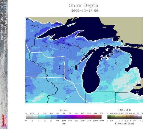
National Snow Map for 12/28/2009 for the Northern Great Lakes Region.
NOHRSC | http://www.nohrsc.nws.gov/nsa/
The second snow map is harder to put into pictures, but very easy to describe: snow depth on the sidewalk on the way into work today. The University of Michigan Grounds and Waste Management Department has a comprehensive snow removal procedure manual for making sure the university campus is open in any winter snow event. Cross the town/gown boundary, and every property owner is individually responsible for their own sidewalk. If a little truck with a brush is chugging by sweeping away the accumulation, you're on campus; if you can see your tracks as you go, you're in town.
Edward Vielmetti walks to work, uphill, both ways, in the snow, just for you and for AnnArbor.com. Reach him at 734-330-2465.