
Strange maps and cartographic curiousities from Frank Jacobs
Strange Maps
The collection of maps spans the globe, with the odd, the unusual, and the extraordinary featured. Here is a sample of that collection, pointing you at those maps which depict Michigan.
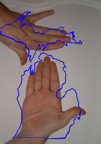
Michigan, the hands-on state
The depiction of Michigan as a pair of hands is easily the most obvious strange map. Long time Michigan residents can not only point to where they live on their hand, but can also trace major highways along their life lines.
Other areas which can be visualized with body parts include San Francisco Bay area (both hands), Cape Cod (use your arm), and the boot of Italy, depicted here on a shoe map of the world.
The Wisconsin fist of solidarity, a symbol of the protests rocking that state, is credited to Lou Kaye and his Rock Netroots weblog.
Metropotamia, Winnemac, or Isola?
A map from Jordan Penny illustrating Thomas Jefferson's division of the Northwest Territory into 10 states puts the Ann Arbor area into Metropotamia, along with the lower third of the lower peninsula, northern Ohio, and northern Indiana. Michigania isn't in Michigan at all in the map, but instead takes up southern Wisconsin.
Sinclair Lewis's fictional Winnemac is in roughly the same place, with the 12,000-student University of Winnemac at Mohalis, 15 miles from Zenith.
An odd reconstructions of the map of the states by Leopold Kohr puts Michigan into Isola, short for "isolated" or "Island", along with 13 other Midwestern states.
Sports maps
The United Countries of Baseball map puts the Washtenaw County area squarely in the "Tigers" nation. Almost all of Michigan is in the Tigers camp except for a corner of southwestern Michigan that crosses over into Cubs territory. The Tigers versus Cleveland Indians versus Cincinnati Reds triple point is roughly at Tiffin, Ohio, where a fan's loyalties are expected to be evenly divided.
The NFL Football on TV maps, maintained by the weblog the506.com, tracks a week-by-week map of television distribution of NFL games, giving ample data to help figure out which teams belong to which markets.
Language maps
The pop vs. soda map is one of the most popular on the Strange Maps site, showing southeastern Michigan solidly in the "pop" camp.
The technical term for these maps is an "isogloss" map, and some of the pioneering research in that by University of Michigan linguistic geographer Hans Kurath (1891-1992) is described in this Time Magazine story from 1949. Kurath's 1961 work "The pronunciation of English in the Atlantic States: based upon the collections of the linguistic atlas of the Eastern United States" is available online in full text from Hathitrust; look on p. 200 to see for example how the pronounciation of the word "grease" varies along the east coast.
Edward Vielmetti collects maps for AnnArbor.com. Reach him at edwardvielmetti@annarbor.com.
Comments
Edward Vielmetti
Thu, Feb 24, 2011 : 10:15 p.m.
Garrett Scott reminds me that I didn't mention the northern Ohio towns of Goblu and Beatosu, which are described here: <a href="http://blog.whitneyannetrettien.com/2011/02/hunting-spotted-hiybbprqag-mountweazel.html" rel='nofollow'>http://blog.whitneyannetrettien.com/2011/02/hunting-spotted-hiybbprqag-mountweazel.html</a>