
Webster Township preserves three more farms totaling 220 acres through dedicated millage
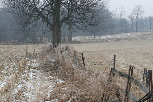
A view of the 78-acre Mast Farm on Mast Road in Webster Township that was recently preserved through the township's farmland and open space preservation program.
Lisa Allmendinger | AnnArbor.com
Editor's note: The year the Mast family purchased the property has been corrected.
Bob Mast's farm has been in his family for more than 100 years, and thanks to the Webster Township Farmland and Open Space Preservation Program, Mast can rest assured that it will never be developed.
"I preserved this in my grandfather's honor," said Mast, whose family purchased the property in 1904.
Mast's farm is one of three in Webster Township, totaling more than 220 acres, that were recently protected by the township's program.
All three properties are primarily agricultural but each has natural features as well, said Barry Lonik, the township’s land preservation consultant.
In each case, the township purchased a conservation easement &to ensure that the land will not be developed and remains in private ownership, he said.
The Mast Farm, about 78 acres, is in at the southeast corner of Mast and Gregory roads, and has a small wetland on the east side. The property has ½-mile of frontage on Mast Road and a ¼ mile of frontage on Gregory Road.
Nearby is the 76-acre Sullivan Farm located on the west side of Mast Road, north of Gregory Road. This farm has both a small wetland and woodlot on the west side.
“These two properties are near each other and near the Nixon Farm,” Lonik said. “I always take great pleasure in protecting property with the name of someone who has a road named after them because there is a long family history there.”
In addition, the township partnered with the Ann Arbor Greenbelt Program to acquire the easement for the Ledwidge Farm on the northwest corner of Joy and Zeeb roads. This property has a small wetland near the road intersection and a woodlot on the north side and is about 65 acres. The Ledwidge Farm is adjacent to two other protected farms, and part of a protected block that covers more than 750 contiguous acres, he said.
All three projects received grants from the federal Farm and Ranchlands Protection Program, which provides financial assistance to municipal governments to protect prime agricultural soils, Lonik said.
“All three property owners donated at least 10 percent of the appraised value of development rights,” he said.
Webster Township’s land preservation program is funded by a dedicated .5 mil tax levy, which brings in about $200,000 a year. It was first approved by township voters in 2005 and renewed in 2009.
The township has received about $7 million in matching funds from other sources; a rate of $7 to $1, Lonik said.
“This represents the maturity of the Webster Township program,” Lonik said and more projects are set to close in coming months.
With these projects, the township program has been involved in protecting more than 1,300 acres, Lonik said.
View Newly protected farms in a larger map
Lisa Allmendinger is a reporter for AnnArbor.com. She can be reached at lisaallmendinger@annarbor.com. For more Dexter area stories, visit our Dexter page.
Comments
John Q
Wed, Dec 22, 2010 : 12:01 p.m.
Nice try but if you're going to say I'm contradicting myself, why not use the words from the same post where I clearly stated that the money is to be spent to "acquire parkland within the city". The difference between what I said and what you said is that I accurately noted that the money is to be spent for both parkland acquisition and the acquisition of development rights on farmland outside the city. You falsely implied that the money is to only be spent on parkland acquisition, hence your claim that money being spent to purchase development rights is being taken from "parkland acquisition money". Nothing could be further from the truth. The truth is that voters approved a millage that is to be used to acquire parkland and to acquire development rights on farmland. That has how the money has been spent. What the city does or does not do with Huron Hills has ZERO to do with how those dollars are spent. The city already owns Huron Hills. It doesn't need to spend money to acquire it. You have consistently and dishonestly stated that money being used to acquire development rights has some connection to that issue. It doesn't. Repeatedly making these false connections between the two doesn't make it any more true now than the first time you did it.
John Q
Wed, Dec 22, 2010 : 10:54 a.m.
"Where is the logic in paying off farmers for lane we will never see with our parkland aquisition money, while we contemplate developing a site within the city?" It's not "parkland acquisition money". The millage is officially called the "Open Space and Parkland Preservation Millage". The purpose of those dollars are to "preserve and protect open space, natural habitats, parkland and the City's source waters inside and outside the City limits for benefit of residents of the City of Ann Arbor and in cooperation with the greater Ann Arbor community." That's exactly what is done with those dollars. They are used to acquire development rights on farms and natural areas outside the city and to acquire parkland within the city. As I previously posted, the city has spent $7 million of those funds to purchase parkland. The logic is that voters were told that approving the millage would allow the city to protect farmland outside the city, as well as acquire parkland within the city. That's what the voters approved. That is what the city has done. Now you come in and demand that the city not do what it promised voters it would do when the millage was approved. Where's the logic in that?
John Q
Tue, Dec 21, 2010 : 11:09 p.m.
The city has spent over $7 million in funds from the millage on parkland acquisitions. The money is being spent exactly how the millage campaign promised it would be spent. Through the federal funds and township partnerships, the millage has been able to leverage far more money and far more land preservation than was initially anticipated when the millage was approved back in 2003. Again, what's your point?
Ann English
Tue, Dec 21, 2010 : 6:56 p.m.
For all who are curious about any subdivisions of single-family housing in the area, there is one east of Huron River Drive, between North Territorial and Gregory Road.
John Q
Tue, Dec 21, 2010 : 8:29 a.m.
What part of that don't you understand? The portion that is allocated for parkland isn't being used to buy farmland. Whatever money is available to purchase development rights on farms was never intended to be used to buy parkland, as your own post shows.
John Q
Mon, Dec 20, 2010 : 10:06 p.m.
"it is beyond ridiculous to give AA park money to these farmers while we talk about developing Huron Hills." The city doesn't give AA park money to farmers. Want to try learning something about how the program works before making misinformed commentary?
Ann English
Mon, Dec 20, 2010 : 7:04 p.m.
I remember the Ledwidge Farm best by the satellite dish sitting on the ground on the right side of the house. The farm at the northeast corner of Gregory and Zeeb is probably already preserved; they have llamas outside in the warmer months. Woodlots cleared away? Perhaps that needed to be done for some Webster Township residents to have driveways extending to two roads, such as Scully in the back of the house and Webster Church Road in front, or Merkel Road far in front, and Donovan Road in back. Scully Road starts at Gregory Road east of Zeeb, and Zeeb Road turns into Merkel Road at its north end.
MsWebster
Mon, Dec 20, 2010 : 1:56 p.m.
Preserving the rural and natural areas of Webster Township allow everyone in the surrounding developed areas the opportunity to enjoy the countryside that lies just outside the city limits. Webster Township's agricultural heritage is important to the taxpayers of Webster Township and people who support the greenbelt initiatives.
Jack
Mon, Dec 20, 2010 : 11:24 a.m.
This is exactly the best time to protect more land--while the real estate market is temporarily down. Perhaps the best part about this program, however, is that it will SAVE tax dollars in the long run. Sprawl developments which need costly new infrastucture are a major reason for increased property taxes. Better to save the land from development--and save on taxes, too!
John Q
Mon, Dec 20, 2010 : 11:12 a.m.
This is the best time to do it. The development rights can be purchased while land prices are low, allowing the money to go further than it otherwise would.
Top Cat
Mon, Dec 20, 2010 : 10:48 a.m.
Government spending our money to solve a "sprawl problem" that no longer exists and won't anytime soon.
John Q
Mon, Dec 20, 2010 : 10:41 a.m.
"Glad to see more of our money go to some obscure farms we never see." Isn't it terrible when the government does exactly what it said it would do with the tax dollars that voters approved to do that?
beuwolf
Mon, Dec 20, 2010 : 10:15 a.m.
One minor observation, in what is otherwise a laudable program. The woodlot features of the properties should not be viewed as a feature to be enjoyed by the public in the future. The Nixon farm no longer has its woodlot. Part of the proceeds from the sale of development rights was used to cut down the woodlot, increasing the amount of tillable land, and increasing the farmer's cash flow. All of which are allowed, unless prohibited in the purchase agreement. Can Mr. Lonik do anything to better preserve the woodlots of farms who have enjoyed the PDR sale money. Can
Killroy
Mon, Dec 20, 2010 : 9:05 a.m.
Excellent! It is hard to race with all this sprawl.