
Power out in some areas of Washtenaw County following thunderstorms; watch now over
Editor's note: A photo and details about damage have been added to this story.
Power is out in parts of Ann Arbor and other areas of Washtenaw County after a line of thunderstorms moved through the area.
There were also reports of downed trees and wires in the area.
In Ann Arbor, a tree appeared to have fallen on power lines at Washtenaw Avenue and Hill Street. Fire department officials said trucks were out today on different calls of downed trees and power lines, with the biggest one on Second Street by Madison Street where a limb from a big tree fell on three cars. There were a few calls from the area north of Washtenaw, south of Geddes, officials said.
In Ypsilanti Township, firefighters also were called out to several calls of multiple trees and wires down.
DTE Energy spokesman John Austerberry told AnnArbor.com earlier today about 26,000 customers were without power throughout DTE's southeast Michigan service area.
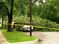
A fallen tree sits atop a car on South Forest Street near Roosevelt in Ann Arbor this afternoon in this photo submitted by reader Mary Ann Dunn.
Photo by Mary Ann Dunn
He did not have information about the location of specific areas without power but a DTE outage map indicated more than 1,000 customers without power in central and south Ann Arbor. It also showed areas with interrupted service north of Ann Arbor in Northfield and Webster townships. Parts of Livingston County, including Putnam and Hamburg townships, also had customers without power, the map indicated.
A severe thunderstorm watch for Washtenaw County was called off at about 4:45 p.m.
Austerberry said it's too early to estimate when power might be restored to areas without it. "That line of storms has gone through just about every county that we service," he said.
He said it will take time to fully understand the extent of the repairs needed.
Comments
Ariel
Wed, Jul 28, 2010 : 9:59 p.m.
Power went out at Dixboro and Green for about 30 minutes at 7:15PM...right in the middle of me cooking dinner.
Ronn
Wed, Jul 28, 2010 : 9:57 p.m.
That storm today was a lot more damaging then it looked as it passed through but all the damage after the storm say's BOY, it was bad today.
dading dont delete me bro
Wed, Jul 28, 2010 : 9:09 p.m.
@cash, you are welcome. @chris goosman, they are emails sent to all skywarn skywatchers. i'm not going to spend time searching for a link. the link would show the same thing, in caps too.
Cash
Wed, Jul 28, 2010 : 6:37 p.m.
dading, Thank you a lot for taking the time to give us this information. Very helpful.
Chris Goosman
Wed, Jul 28, 2010 : 6:10 p.m.
While I share Stefanie's concern about all caps comments, these are copied directly from the National Weather Service website. Personally, I'd rather see links to the storm reports than a wholesale copy and paste, all caps or not.
dading dont delete me bro
Wed, Jul 28, 2010 : 4:04 p.m.
Subject: Local Storm Report 252 NWUS53 KDTX 282054 LSRDTX PRELIMINARY LOCAL STORM REPORT NATIONAL WEATHER SERVICE DETROIT/PONTIAC MI 454 PM EDT WED JUL 28 2010..TIME......EVENT......CITY LOCATION......LAT.LON.....DATE.......MAG......COUNTY LOCATION..ST.....SOURCE......REMARKS.. 0320 PM TSTM WND DMG 2 E YPSILANTI 42.25N 83.58W 07/28/2010 WASHTENAW MI FIRE DEPT/RESCUE LARGE 3 FOOT DIAMETER TREE CRUSHED 2 CARS AND ROOF DAMAGED RKULIK
dading dont delete me bro
Wed, Jul 28, 2010 : 3:35 p.m.
Subject: Local Storm Report 530 NWUS53 KDTX 282014 LSRDTX PRELIMINARY LOCAL STORM REPORT NATIONAL WEATHER SERVICE DETROIT/PONTIAC MI 414 PM EDT WED JUL 28 2010..TIME......EVENT......CITY LOCATION......LAT.LON.....DATE.......MAG......COUNTY LOCATION..ST.....SOURCE......REMARKS.. 0325 PM TSTM WND DMG 3 E YPSILANTI 42.24N 83.57W 07/28/2010 WASHTENAW MI FIRE DEPT/RESCUE 14 INCH DIAMETER TREE DOWN ON HOUSE RKULIK
dading dont delete me bro
Wed, Jul 28, 2010 : 3:23 p.m.
http://www.dteenergy.com/map/zipCodeOutageMap.pdf
dading dont delete me bro
Wed, Jul 28, 2010 : 3:19 p.m.
SEVERE WEATHER STATEMENT NATIONAL WEATHER SERVICE DETROIT/PONTIAC MI 406 PM EDT WED JUL 28 2010 COUNTY SPECIFIC MESSAGE: /O.CAN.KDTX.SV.W.0076.000000T0000Z-100728T2030Z/ WASHTENAW MI- 406 PM EDT WED JUL 28 2010...THE SEVERE THUNDERSTORM WARNING FOR SOUTHEASTERN WASHTENAW COUNTY IS CANCELLED... THE LINE OF STORMS WHICH PROMPTED THE WARNING HAVE MOVED OUT OF THE WARNED AREA.
dading dont delete me bro
Wed, Jul 28, 2010 : 2:39 p.m.
SEVERE WEATHER STATEMENT NATIONAL WEATHER SERVICE DETROIT/PONTIAC MI 330 PM EDT WED JUL 28 2010 COUNTY SPECIFIC MESSAGE: /O.CON.KDTX.SV.W.0076.000000T0000Z-100728T2030Z/ WASHTENAW MI-WAYNE MI-MONROE MI- 330 PM EDT WED JUL 28 2010...A SEVERE THUNDERSTORM WARNING REMAINS IN EFFECT FOR NORTHEASTERN MONROE...WAYNE AND SOUTHEASTERN WASHTENAW COUNTIES UNTIL 430 PM EDT... AT 325 PM EDT...NATIONAL WEATHER SERVICE DOPPLER RADAR INDICATED A LINE OF SEVERE THUNDERSTORMS CAPABLE OF PRODUCING DAMAGING WINDS IN EXCESS OF 60 MPH. THESE STORMS WERE LOCATED ALONG A LINE EXTENDING FROM DOWNTOWN DETROIT TO WILLIS...MOVING EAST AT 25 MPH. SEVERE THUNDERSTORMS WILL BE NEAR... ECORSE AND TAYLOR AROUND 335 PM EDT. NEW BOSTON AND SUMPTER TOWNSHIP AROUND 340 PM EDT. SCOFIELD AND MAYBEE AROUND 345 PM EDT. WILLOW AND BROWNSTOWN TOWNSHIP AROUND 350 PM EDT. ERIE AND LA SALLE AROUND 355 PM EDT. LUNA PIER AND FLAT ROCK AROUND 400 PM EDT. THE WARNING INCLUDES AREAS SURROUNDING THESE LOCATIONS... DETROIT... WYANDOTTE... WILLIS... TRENTON... YPSILANTI... TAYLOR... ROMULUS... MONROE... MILAN... MAYBEE... LUNA PIER... GROSSE ILE... FLAT ROCK... DOWNTOWN DETROIT... DEARBORN... CARLETON... CANTON... BELLEVILLE...