
Friday snowstorm predictions
Another storm is on the way, scheduled to hit on Friday. Here's a current prediction, collected on Thursday, from the National Weather Service's Hydrometeorological Prediction Center showing a 95% chance of 2 or more inches of snow.
The Thursday prediction map shows changes from the same forecast from 24 hours ago. The confidence in the storm track is greater, and the intensity of the storm is greater than it was before; in addition, the storm path has moved a bit south.

Thursday's predictions for Friday's storm.
Hydrometeorological Prediction Service
The Wednesday prediction map shows changes from the same forecast from 24 hours previous. The storm intensity in the area has weakened somewhat, with the general storm track further to the south; in addition, a second storm track is expected to provide snowfall on Saturday.

Friday storm forecasts, as seen on Wednesday. The storm track for the Friday storm has moved south compared to Tuesday's forecast, but a second storm follows the first.
Hydrometeorological Prediction Service
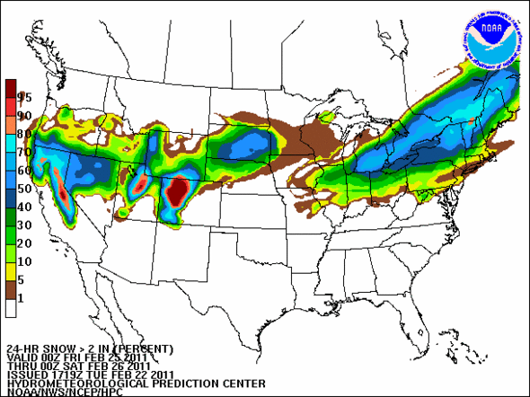
The forecast for Friday snow, as seen on Tuesday, is for a 50% chance of at least 2 inches of snow.
Hydrometeorological Prediction Center, National Weather Service
Predictions change; this page will update as I get more forecasts in; do your own forecasting on the HPC Experimental Probabilistic Winter Precipitation Guidance page, and give the National Weather Service product feedback with your experiences.
Edward Vielmetti collects maps for AnnArbor.com.
Comments
Macabre Sunset
Fri, Feb 25, 2011 : 12:51 a.m.
It moved back a little to the north today, not the south. I've been following this one very closely, as I'm supposedly on vacation this weekend. Might not be able to get where I'm going, though it looks a lot better for getting out of Michigan easily.