
Posted on Wed, Feb 2, 2011 : 9:35 a.m.
National snowfall maps from NOHRSC
By Edward Vielmetti
The National Operational Hydrological Remote Sensing Center (NOHRSC) prepares a National Snow Analysis to show how much snow has come down nationwide. It uses a mixture of field reports, radar analysis and aerial surveys to estimate both snowfall from the current storm and total snow on the ground.
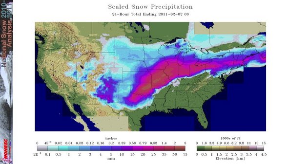
Heavy snowfall, as measured by NOHRSC, stayed mostly to the south of the Ann Arbor area. This map shows 24-hour accumulations for Tuesday, and does not include any Wednesday morning snowfall.
National Snow Analysis, NOHRSC, National Weather Service
Links
- National Snow Analysis, NOHRSC. A top level view of all of the snow analysis products.
- National Snow Analyses 3D Interface. Interactive visualizations of snow provided through KML files suitable for loading into Google Earth.
- Snow Forecasts. NOHRSC takes snow forecasts from other agencies, including the Hydrometeorological Prediction Center, and reformats them into KML formats for 3D viewing.
Edward Vielmetti watches the snow fall for AnnArbor.com.
Comments
Cash
Wed, Feb 2, 2011 : 3:57 p.m.
Okay Edward, this is scary. I was just going to Google a map of snow fall amounts from this storm and BAM....here's Edward! Thank you!