
Cleanup of polluted MichCon site on Huron River in Ann Arbor will start in August
DEQ officials showed a photograph of the old MichCon site believed to be taken around 1936 when large gas holders and oil tanks still stood near the river.
Ryan J. Stanton | AnnArbor.com
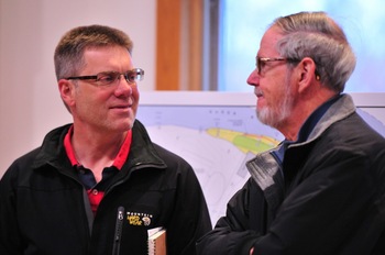
Nearly 50 people packed into Cobblestone Farm Tuesday night to hear Michigan Department of Environmental Quality official discuss the plans submitted by DTE Energy.
MichCon has been a subsidiary of DTE since 2001. It ran a manufactured gas plant along the south bank of the Huron River decades ago and left the site polluted — a problem DTE inherited and is now working cooperatively with the DEQ to address.
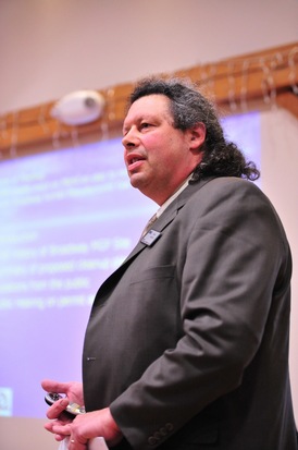
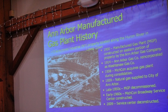
A summary of the cleanup plan was provided by District Supervisor Mitch Adelman, who also gave a report on the property's background.
Ryan J. Stanton | AnnArbor.com
The site where the cleanup is expected to happen this year is nestled between the Argo Dam and the Broadway bridges near the Amtrak train station.
There appears to be strong public support for cleaning up the property, which city officials hope to turn into a riverfront park eventually.
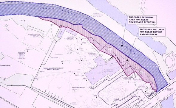
"The remediation along the riverfront encompasses about 1,000 linear feet of shoreline," Wiesemann said. "We're looking at excavating around 22,500 cubic yards of impacted soil and sediment."
A handful of DEQ officials were in attendance for Tuesday's forum, including Ray Spaulding of the Remediation Division, James Sallee of the Water Resources Division, and Frank Ruswick, deputy director for the DEQ's Office of the Great Lakes.
DEQ District Supervisor Mitch Adelman gave a summary of the cleanup plan as well as a report on the property's background.
"There are some risks to human health and the environment from either the sediments or soils and that leads us to the plan that we've got in front of us," he said, describing some of the contaminants as "very viscous, dense, thick, black, smelly things."
He showed a photograph of the site believed to be taken around 1936 when large gas holders and oil tanks still stood near the river.
"This is but one of many former manufactured gas plant sites that are in the state of Michigan," Adelman said. "These are one of our legacies we all get to deal with."
Adelman said the DEQ is going to be closely reviewing the plans, but he doesn't anticipate any problems with DTE's ability to complete the remediation work in a safe manner.
"Our initial review is that this is a really good next step toward environmental remediation and bringing the facility to closure," he said, noting that additional remediation will be needed after this year's cleanup to be able to give the entire property a clean bill of health.
A history of pollution
According to information provided by the DEQ, MichCon and its predecessors operated a manufactured gas plant at the site from about 1900 until the late 1940s.
Consumer gas was produced on the site using a process that mixed coal and petroleum. During the manufacturing process, coal tar and other impurities were removed. Some of the industrial waste byproducts still contaminate the area today.
In the late 1950s, the plant was decommissioned and the site was converted into a MichCon service center by the early 1960s. Those operations were discontinued in 2008 and the main service center building was demolished between late 2009 and early 2010.
Adelman said the site has been on the DEQ's radar for years, with preliminary investigations into groundwater discharging into the Huron River dating back to 1985.
In 1993, a hole was found in a 12,000-gallon unleaded gasoline underground storage tank. During the course of the repair, about 3 inches of gasoline was discovered on top of the water table at a depth of four feet below grade. In addition to 113 gallons of "free product" being recovered, a site-wide investigation was conducted in 1996.
According to the DEQ, MichCon has spent $2.6 million performing site investigation and cleanup of 7,500 tons of soil and 1.3 million gallons of groundwater.
Over the years, MichCon has conducted a number of other investigations and interim environmental cleanup activities — with a focus on groundwater, soils and potential concentrated waste where gas manufacturing historically took place.
More recently, the focus has been on sediments in the main river channel between Argo Dam and the Broadway bridges.
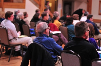
Nearly 50 people packed into Cobblestone Farm Tuesday night to hear Michigan Department of Environmental Quality official discuss the plans submitted by DTE Energy.
Ryan J. Stanton | AnnArbor.com
That was followed by installation and operation of a groundwater treatment system from 2000 to 2005. Another 4,340 cubic yards of impacted soil were removed from the eastern part of the property in 2006, followed by removal of a storm sewer outfall in 2011.
Investigations have shown contaminants related to the former plant are present in sediments — but not in river water — at levels that may pose an unacceptable risk to human health and the environment, according to the DEQ.
Polycyclic aromatic hydrocarbons, which can cause health problems such as cancer, have been found in sediment at upstream locations and next to the MichCon site. According to the DEQ, the levels peak at near-shore areas in the vicinity of the former plant where a sheen is observed when the sediment is disturbed.
That's generally limited to within 15 feet of the south river bank, extending about 850 feet along the shoreline adjacent to the MichCon site, according to the DEQ.
Cleaning up the riverfront
DTE's plan is to dredge contaminated sediments from the main channel of the Huron River between Argo Dam and the Broadway bridges and also remove contaminated soils along the river banks to achieve an unrestricted residential cleanup standard. That means, for instance, the area being cleaned up will be considered safe to use as a public park.
Clean soil and rip-rap backfill will be placed in the river and the shoreline will be restored with new trees and other vegetation, according to the proposed plan.
After this year's cleanup, the DEQ is expecting DTE Energy to come forward with a proposal for final remediation of the remainder of the site within the next few years.

Shayne Wiesemann
Asked what the long-term plan is for the property and whether it could become a riverfront park, Wiesemann said DTE's focus is on this year's cleanup for now.
"In the terms of the whole property, we're waiting until we figure out what the final end use of the property is going to be so we can determine what the appropriate level of remediation is for that portion of the site," he said. "There's an understanding that there's a lot of potential for redevelopment of the site, but we're 100 percent focused on the remediation project.
"That being said, our leadership has a vision that this site is going to be one of an economic catalyst and will be used by the public for enjoyment."
Ann Arbor resident Stephen Kilijanczyk, who lives near Summit Street and Fourth Avenue across from Wheeler Park, voiced support for moving forward with the cleanup. An avid kayaker and paddle-boarder, he said he's looking forward to seeing a public use for the site.
"I see how it can be a major improvement to the area, especially for the fact that we've got that new waterway in for the kayaks," he said. "I feel it's crazy how they haven't developed this place. It's amazing. It's like a diamond in the rough — the whole riverfront.
"Ann Arbor has a riverfront and we're not using it."
City Council Members Stephen Kunselman, D-3rd Ward, and Jane Lumm, an Independent from the 2nd Ward, both attended the forum, as did a number of city staff members.
"I do hope that this property eventually becomes a city park. I think it will make a great addition to the Huron River greenway, which I think is really important," Kunselman said.
Commenting on the fact that the property is in a floodplain, Kunselman said it's probably not the best site to construct buildings, but he's not ruling out the possibility of a new train station, which is one idea some people have kicked around.
"I'm not as inclined to say 'no train station' there," he said. "I think that still remains to be seen, and to be honest, I think that's something the feds are going to have more of a decision than the local government, so I'll kind of let that one take its course."
Donald Gray, professor emeritus of civil and environmental engineering at the University of Michigan, chats about the project with Russ Miller, left, before the start of the forum.
Ryan J. Stanton | AnnArbor.com
They've both been closely following the debate over whether to remove Argo Dam, which has died down in the last year or two. Gray was concerned removing the dam would redirect the river through the polluted MichCon site, because that's its natural course.
"I'm delighted to see this happening," Gray said of the cleanup.
"I'm glad to see it moving forward and I'm hoping we can have at least a strip of it that can be park, because it really kind of completes the trail," Miller added. "We have this huge green swath through the city on either side of the river, so this is one of the last pieces of it."
Responding to a resident who asked how far downstream the MichCon contamination extends, Wiesemann said DTE Energy has done limited sediment sampling past the Broadway bridges and the results haven't been a cause for concern.
He said most of the contamination is located in front of the former plant site, but there could be some downstream impacts and that will have to be looked at in the future.
Ann Arbor resident Rita Mitchell asked about the restoration of plants along the riverbank. Wiesemann said DTE has been working with the city and the Huron River Watershed Council to come up with a nice riparian habitat that will include native grasses, shrubs and trees.
A DEQ official said Tuesday night there are dozens of former manufactured gas plant sites just like the one in Ann Arbor that are scattered across the state.
Ryan J. Stanton covers government and politics for AnnArbor.com. Reach him at ryanstanton@annarbor.com or 734-623-2529. You also can follow him on Twitter or subscribe to AnnArbor.com's email newsletters.
Comments
blahblahblah
Wed, Apr 11, 2012 : 7:26 p.m.
Too bad our local government has no interest in leveraging the possible expansion of the current station site as a way to expedite remediation of the entire Michcon site.
DonBee
Wed, Apr 11, 2012 : 7:09 p.m.
There is no contract with the city for this to turn into a park. It will have commercial value, so don't get your hopes up that it will indeed become a public park. Once cleaned up, it could support several multi-million dollar homes on the river front. That use would provide tax revenue for the city, schools and county. It would also be urban infill which the city government says they want. As my grandfather used to say "don't count your chickens before they are hatched"
George Gaston
Wed, Apr 11, 2012 : 7:56 p.m.
Most of this DTE property is classified as either floodplain or floodway. It will be challenging, if not impossible, to build on.
Arboriginal
Wed, Apr 11, 2012 : 4:14 p.m.
Will the park feature a Mullet?
Bababooey
Wed, Apr 11, 2012 : 7:54 p.m.
Would that be considered a 'hot spot'. Would sediments and pollutants be attracted to this mullet area you speak of??
Rita Mitchell
Wed, Apr 11, 2012 : 3:55 p.m.
The focus of the cleanup is on the river edge. After extraction of significant amounts of pollutants, a barrier will be placed, with the intent of preventing river water contact with any remaining polluted soil. The barrier will be covered with rip rap, then plants, and further from the water's edge, trees will be planted. My understanding from a discussion after the presentation is that the site will require monitoring long-term, to assure the status of the protective barrier. The result will be a significantly different look to the river edge, likely without the tall trees that are familiar to us currently. There was no discussion of contaminants or remediation of the large, grassy section of the site that is west of the paved site.
George Gaston
Wed, Apr 11, 2012 : 3:20 p.m.
This DTE site is a large parcel of property waiting to become an urban asset. There is more than enough land here to provide a riverside park with a connecting link of the Border-to-Border trail and the river treminus for the Allen Creek Greenway. This area is also a much better location for rail centric transportation. Wherever a multiple track station is located in our community, ADA requirements will necessitate a concourse over the tracks with elevators providing access to all the tracks that may eventually be involved. The railroad already owns a substantial amount of property at its present location with access to both Depot Street and Broadway. Short term parking and a bus transportation center could be located on the Depot Street side and longer term parking could still be provided across the tracks, where it is now. For those with vision, this is the only location where the east-west rails and the north-south rail lines intersect and a rail hub could be created. Also, building a new railroad station in a city park would put the city in the railroad business. Would this be a wise ongoing commintment of city funds at a time when the city is having to reduce basic city services, such as fire and police protection?
amlive
Wed, Apr 11, 2012 : 1:52 p.m.
If the property is developed for public use, I think the next issue would be public access. Currently the only access point is on the very western tip at Broadway, with the whole south and eastern perimeters blocked off by the railroad tracks. Actually, there is no other "official" public access to the east side of the river at all until you get way up North Main to Longshore Drive at Bandemer park. Of course plenty of folks park at the old canoe shop on main by the RR bridge and "trespass" across the tracks. If this area is developed in to a park though, I'm sure Peter Allen and other property owners there can only tolerate so much use of their private parking lots for public park access before it becomes too big a nuisance. I'm glad their focusing on the clean up right now, and I'd love to see it developed in to a thriving waterfront area accessible to public use. To make the most of it though, I really think public access closer to the southwest corner would be critical. With the border layered by railroad then private business property however, this could be quite a challenge to provide.
amlive
Wed, Apr 11, 2012 : 3:37 p.m.
Daah - Thank you Foobar, yes, you're right. I must have put my brain in backward this morning.
foobar417
Wed, Apr 11, 2012 : 3:19 p.m.
I don't mean to nitpick, but I think you have the east/west directions backwards. The car entrance is off the Broadway Bridge at the *eastern* end of the property and leads to the Amtrak parking lot. There's also stairs down to the Amtrak parking lot. The south is blocked off by the tracks. At the *western* end, you could theoretically have a pedestrian walking path from the dam down into the site, but you'd have to get there via Lakeshore Drive / Bandemer Park or via Argo Canoe Livery / dam / Bandemer Park.
amlive
Wed, Apr 11, 2012 : 1:55 p.m.
"glad *they're* focusing on the cleanup*
Ross
Wed, Apr 11, 2012 : 12:41 p.m.
Awesome. Good article, Ryan. I have always wondered how this amazing piece of real estate could languish for so long. How about some riverfront restaurants/breweries with outdoor decks overlooking the new kayaking features in the river? And nice big park, too.