
Thunderstorms move through Washtenaw County, hitting Ypsilanti Township the hardest
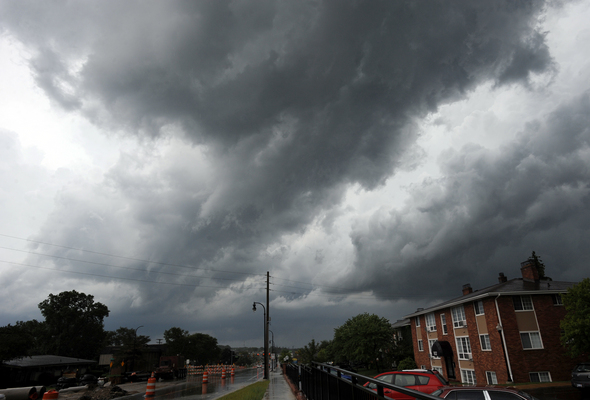
Storm clouds move through the west side of Ann Arbor during today's fast-moving storms.
Melanie Maxwell | AnnArbor.com
A severe thunderstorm quickly swept through Washtenaw County this afternoon, with reports of large hail and damaging winds in Ypsilanti Township.
By 2:45 p.m., the storms had moved into Wayne and Oakland counties.
A tornado warning issued for the county expired at 2:45 p.m. However, a severe thunderstorm watch remains in effect for Washtenaw County until 7 p.m.
Today's storm was the latest in a series of severe thunderstorms in Washtenaw County in recent weeks.
Marc Breckenridge, director of the county's Emergency Management Division, said the EOC received reports that Ypsilanti Township was hardest hit today, with possible downed wires and trees. Heavy ran, hail and high winds were reported in the area of Whittaker and Meritt Road.
However, the Ypsilanti Township Fire Department said firefighters didn't respond on any weather-related calls.
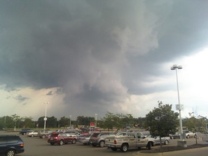
Rachel Parviz took this photo from the parking lot of Meijer in Scio Township Sunday afternoon.
Photo courtesy of Rachel Parviz
Meteorologists are watching for possible redevelopment of some storms as a cold front moves through, according to the National Weather Service.
The storm system was traveling at 40-45 mph, and SkyWarn spotters reported seeing visible rotations in the clouds, Breckenridge said. That means the storm easily could have produced tornadoes, but no touchdowns were reported in the county, he said.
Some street flooding has been reported, including at the intersection of Dixboro and Geddes. The rainfall was measured at three-tenths of an inch in Pittsfield Township.
Wind gusts up to 50 mph were reported in Saline, and large hail was reported in the Ypsilanti area. This storm had less lightning than previous ones, officials said.
A DTE Energy power outage map updated at 2:46 p.m. showed 101 to 1,000 customers in the Saline area without power.
Breckenridge said flooding is becoming a major concern due to the volume of recent storms.
"The ground is saturated, and it really can't take another storm that has 1 or 2 inches of rain," he said. "The water has to go somewhere."
Should the pattern continue, the area is on track to have the most active thunderstorm season since 1993, Breckenridge said.
"We were activating constantly in summer of 1993," he said. "I hope that's not the case. This is certainly the most active in recent memory."
Two tornadoes touched down during storms Wednesday night, one south of Saline and one south of Milan. No serious damage was caused.
A tornado touched down in Dundee in early June, resulting in significant damage.
Comments
Paul the Malcontent
Mon, Jun 28, 2010 : 1:54 p.m.
@SonnyDog: Exactly. I hope you contacted Fox 2 to express your displeasure. I'm all for breaking in to announce the warning and show where the storms are tracking, but the 2+ hours of continual "playing with their cool weather toys" was overkill to me, especially in light of the fact they were preempting a sporting event that they don't have broadcast rights for reairing. Channel 7 did much better at being less intrusive; they were airing a show around 1:20pm when I flipped over with the standard crawl and graphic indicating the warnings, and later had a split-screen during the World Cup game.
Spencer Thomas
Mon, Jun 28, 2010 : 1:24 p.m.
Monica: An apparent tornado touched down south of Belleville, and rotating clouds were spotted in Ann Arbor. Neither is very far from Ypsilanti. These things move fast and change quickly. A little inconvenience from a warning is a lot better than injury or death from not being warned. (See http://www.spc.noaa.gov/climo/reports/100627_rpts.html for the National Weather Service's tornado reports from yesterday's storm.)
SonnyDog09
Mon, Jun 28, 2010 : 10:50 a.m.
I didn't mind the warning. I did mind Fox taking the Formula One race off the air to show me the weather radar. The race was on Sunday morning and wasn't shown live on Speed like it normally is. They showed it on Fox on tape delay beginning at noon. Instead of seeing the end of the race, I got to watch the weather radar and listen to the local weather guy keep telling us that something might happen at any minute. If I had wanted to watch the weather radar, I would have switched to the channel that shows that.
Barb
Mon, Jun 28, 2010 : 9:46 a.m.
I think both @Monica @jcj make good points. The more warning we can give people, the better but I think it's also true that these "warnings" which used to denote true serious weather, have turned into what a "watch" was, which is already being taken much less seriously. I wonder if there's something in the middle that can be used to explain the actual situation at hand which *can* be serious in nature but isn't guaranteed to be. Just a thought.
dading dont delete me bro
Mon, Jun 28, 2010 : 6:51 a.m.
@huh7891, wut are you talking about? @annarbor.com, is there a way to 'communicate' w/other posters?
jcj
Mon, Jun 28, 2010 : 6:38 a.m.
@ Monica Ross-Williams Now that we have your opinion I will give you mine. There was a person killed at a campground north of Detroit and numerous camper destroyed and thrown into the lake. If the weather service had waited until someone saw a tornado there would be an outcry from all of those inconvenienced by the warning! Just because YOU did not get what you considered threatening weather in your little corner of the world does not mean it did not happen. Just watch the news today for proof!
Wolverine3660
Mon, Jun 28, 2010 : 6:11 a.m.
@Melanie Maxwell- that is a great photograph!!!!!!
Monica
Mon, Jun 28, 2010 : 3:06 a.m.
The Tornado Warning was unnecessary in my option. First, it was called at 1:30 PM and the so-called storm did not roll into Ypsilanti Twp. until about 2:30 PM or so. Second, the WORST that happened was the hard rain. EAS better watch their calls a little better or they will be like the boy that called wolf before the end of the summer.
huh7891
Sun, Jun 27, 2010 : 8:57 p.m.
Er dading...is that what I think it is?
dading dont delete me bro
Sun, Jun 27, 2010 : 3:34 p.m.
reported at whittaker and merrit roads...
dading dont delete me bro
Sun, Jun 27, 2010 : 3:32 p.m.
indeed, 3/4 inch hail, high wind, and heavy rain were reported by a washtenaw co trained spotter. (i'm on this list) i can forward the email to someone if needed to verify this. annarbor.com has my email. shoot me the request. i changed my profile pic, per their request.
jjc155
Sun, Jun 27, 2010 : 3:23 p.m.
we had heavy rain and pea size hail in area of Tuttlehill and textile, certainly was not a bad storm by any stretch of the imagination.
Tammy Mayrend
Sun, Jun 27, 2010 : 3:18 p.m.
We hid out in the basement but it certainly didn't feel like this was one of the worst storms this year - We're at the area where it was reported at the worst (Whittaker/Merrit) - I thought I heard hail though.
tdw
Sun, Jun 27, 2010 : 2:38 p.m.
Ypsi Twp. covers a lot of area.Can you narrow it down a little?It just rained hard here for a few minutes