
Updated forecast: Bulk of snow will hit Ann Arbor on Friday
Colliding low pressure systems still are expected to dump 2 to 4 inches of snow on the Ann Arbor area starting tonight, but the bulk of the snow will come on Friday, forecasters now say.
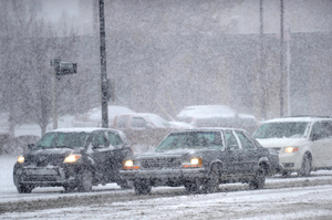
Ann Arbor drivers may be dealing with weather like this on the way to work Friday.
Melanie Maxwell | AnnArbor.com
At the moment, forecasters are not expecting to see particularly heavy periods of snow.
The Washtenaw County Road Commission will be ready when the snow comes, director of operations Jim Harmon said today.
A four-person night crew will begin work at 8 p.m. focusing on plowing and salting interstates and state highways, he said. Supervisors will monitor conditions throughout the night in case extra plows need to be called in. At 4 a.m., a full crew will report to man the county’s entire fleet of 46 snowplows.
The snow comes along with much colder temperatures than we’ve been enjoying. The low is expected to drop to about 26 tonight. The high Friday will be about 31 with blustery conditions. Friday night, there’s a 40 percent chance of snow showers. The low will drop to about 17 degrees. The weekend promises to be cold with highs Saturday and Sunday in the 20s and lows in the teens.
The snow is coming as the result of a collision of cold air moving down from Canada and moist air moving up for Louisiana, forecasters said.
For forecasts and conditions any time, check AnnArbor.com's weather page.
Contact Cindy Heflin at 734-623-2772 or cindyheflin@annarbor.com or follow her on Twitter.
Comments
Sparty
Fri, Jan 13, 2012 : 10:13 p.m.
Guess you didn't see the reports of the hundred or so accidents posted in other locations, including Ambulances, school busses, etc. Most of you are looking kinda of foolish right about now.
Bertha Venation
Fri, Jan 13, 2012 : 3:30 p.m.
'Zanybody know how to jumpstart a Hoveround???
Roaring_Chicken
Fri, Jan 13, 2012 : 1:30 p.m.
From the National Weather Service office in White Lake, "Last Update on Jan 13, 7:53 am EST": "Today: Snow showers before 9am, then snow and areas of blowing snow before 4pm, then scattered snow after 4pm. High near 27. Blustery, with a west northwest wind between 17 and 21 mph, with gusts as high as 30 mph. Chance of precipitation is 100%. Total daytime snow accumulation of around an inch possible. " "... around an inch ... " Guess I'd better go put the chains on and make sure I have candles, food, and blankets in the trunk for that commute to Starbucks ...
Another Michael
Fri, Jan 13, 2012 : 12:52 p.m.
Strange commute this morning. Drivers were appropriately cautious for the conditions, and I didn't pass any accidents. It's like I woke up in the Twilight Zone.
Another Michael
Fri, Jan 13, 2012 : 1:54 p.m.
I guess leaving a few minutes early put me ahead of the carnage.
justcurious
Fri, Jan 13, 2012 : 1:37 p.m.
I don't know where you are but I have never heard so many accidents reported on the scanner.
pbehjatnia
Fri, Jan 13, 2012 : 1:47 a.m.
8:45 p.m.: well, i just checked our high tech snow plow tracking system cuz they're supposed to be out and working since 8:00 p.m. you know, for the snow that might start falling about 3 a.m.? so far not dots on the screen cuz there's no snow to plow cuz it ain't snowing in the deuce nor will it for several hours, but we gotta have an extra crew on board already at 8 p.m. just to make the union happy? or why? i just see more tax $$ melting like frosty.
OLDTIMER3
Fri, Jan 13, 2012 : 11:47 a.m.
While driving on Parker Road at 9:30 last night it didn't long to discover that the road was very slippery in a lot of places. Especially on the big s curve connecting Pleasant Lake Rd and Parker.I watched a car going East on PL slide until his wheels hit the shoulder of the rd, then he slowed way down quick.
jrigglem
Fri, Jan 13, 2012 : 1:43 a.m.
"The snow comes along with the much colder temperatures that we've been enjoying" We've been enjoying cold temperatures? As I recall it's been a mild 40 plus degrees for a couple weeks now. I might be alone in this, but I'm glad to finally be seeing some snow. I'm gonna hate driving in it, but what is winter without snow?
garrisondyer
Fri, Jan 13, 2012 : 4:54 a.m.
Agreed. Living in Seattle these days, I miss winter every year. Granted, I can drive to the snow up in the mountains when I want to, but it's just not the same when it's 37-43 degrees every single day instead of 20-30.
RunsWithScissors
Fri, Jan 13, 2012 : 1:41 a.m.
"The sky is falling! The sky is falling!" That'll do, Chicken Little. That'll do.
WalkingJoe
Thu, Jan 12, 2012 : 10:43 p.m.
A little snow to remind us it's January in Michigan. Oh well, at least two of our three dogs will love it.
djacks24
Thu, Jan 12, 2012 : 10:34 p.m.
You can tell its been a mild Winter or a slow news week around here if A2.com has already posted two articles this week over 2-4 inches of predicted snowfall in January.
MRunner73
Thu, Jan 12, 2012 : 10:30 p.m.
They make something so simple sound totally confusing; colliding low presuure systems. This isn't pinball. The moisture feed is associated with the low pressure stsyem. The colder air is sent down from a distant high pressure system, hence, the illusion of collision. The colder and more dense air lifts to warmer and lighter air higher in the atmosphere which then condenses to make more moisture and precipitation. The result is rain changing to snow as the colder air filters in. The brunt of the snow will move out later in the morning on Friday then the measureable snow really tapers off. Western and Northern Michigan will be in the snow accumulating zone much longer than Southeastern MI. Yes, it will look and feel like winter. This is Michigan, not Tennessee.
WalkingJoe
Thu, Jan 12, 2012 : 10:45 p.m.
Uh, colliding low pressure systems sounds simpler to me.
mr54
Thu, Jan 12, 2012 : 10:23 p.m.
According to Local 4 in Detroit a trace to 2" by saturday morning for the area
mr54
Thu, Jan 12, 2012 : 10:20 p.m.
According to local weather services and the Weather Channel this area may get 1 " tonight and 1 " thru tomorrow.
Craig Lounsbury
Thu, Jan 12, 2012 : 10:12 p.m.
"Colliding low pressure systems still are expected to dump 2 to 4 inches of snow on the Ann Arbor area starting tonight, ..." "About 1 to 2 inches can be expected by the morning rush hour and then another 1 to 3 inches during the day on Friday." according to my math .......
Craig Lounsbury
Thu, Jan 12, 2012 : 11:20 p.m.
so we couldn't get the upper end overnight and the upper end during the day which would be 5 inches?
Cindy Heflin
Thu, Jan 12, 2012 : 10:17 p.m.
Hi Craig: 2 to 4 is the forecast for the entire period. We could get an inch overnight and then another 3 on Friday, or 2 inches overnight and then 2 inches on Friday or an inch tonight and an inch on Friday or any of various other combinations.