
Water levels keep kayakers moving on reopened Argo Cascades in Ann Arbor
More Galleries
 The Lunch Room does vegan food in a way that even non-vegans can enjoy
 Images from Dawn Farm's 40th Anniversary Jamboree
 See photos from Kerrytown BookFest
 Images from Michigan's 41-30 win over Notre Dame under the lights
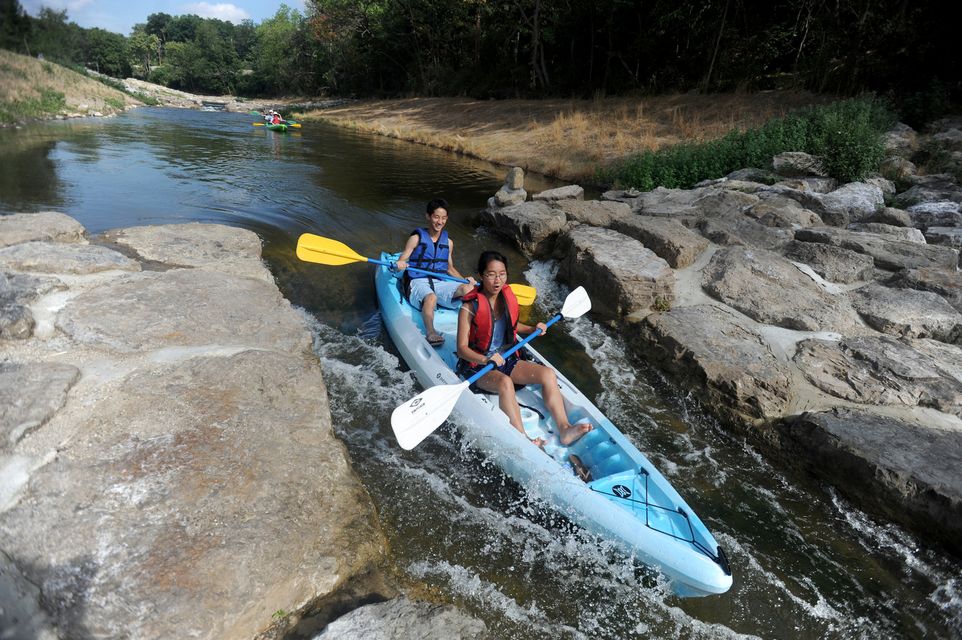
Ann Arbor residents Stephanie Huang, age 20, and her brother Daniel, age 18, take their kayak through the Argo Cascades in Ann Arbor on Saturday morning. Angela J. Cesere | AnnArbor.com
-
 Ann Arbor residents Stephanie Huang, age 20, and her brother Daniel, age 18, take their kayak through the Argo Cascades in Ann Arbor on Saturday morning. Angela J. Cesere | AnnArbor.com
/calendar/photologue/photos/!argocascades/cache/080412-AJC-argo-cascades-02_fullsize.JPG
Ann Arbor residents Stephanie Huang, age 20, and her brother Daniel, age 18, take their kayak through the Argo Cascades in Ann Arbor on Saturday morning. Angela J. Cesere | AnnArbor.com
/calendar/photologue/photos/!argocascades/cache/080412-AJC-argo-cascades-02_fullsize.JPG
-
 Ann Arbor residents Paul and Grace Huang go through the entrance of the Argo Cascades. Angela J. Cesere | AnnArbor.com
/calendar/photologue/photos/!argocascades/cache/080412-AJC-argo-cascades-01_fullsize.JPG
Ann Arbor residents Paul and Grace Huang go through the entrance of the Argo Cascades. Angela J. Cesere | AnnArbor.com
/calendar/photologue/photos/!argocascades/cache/080412-AJC-argo-cascades-01_fullsize.JPG
-
 From bottom to top: Ann Arbor residents Masaki Ito, age 9, goes down the Argo Cascades in a kayak with his mom, Kayo, while his sister Maray, age 9, and father, Fumito, follow in their own kayak. Angela J. Cesere | AnnArbor.com
/calendar/photologue/photos/!argocascades/cache/080412-AJC-argo-cascades-03_fullsize.JPG
From bottom to top: Ann Arbor residents Masaki Ito, age 9, goes down the Argo Cascades in a kayak with his mom, Kayo, while his sister Maray, age 9, and father, Fumito, follow in their own kayak. Angela J. Cesere | AnnArbor.com
/calendar/photologue/photos/!argocascades/cache/080412-AJC-argo-cascades-03_fullsize.JPG
-
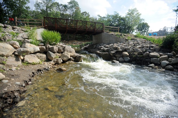
 The Argo Cascades empty out under a footbridge near Broadway St. in Ann Arbor. Angela J. Cesere | AnnArbor.com
/calendar/photologue/photos/!argocascades/cache/080412-AJC-argo-cascades-04_fullsize.JPG
The Argo Cascades empty out under a footbridge near Broadway St. in Ann Arbor. Angela J. Cesere | AnnArbor.com
/calendar/photologue/photos/!argocascades/cache/080412-AJC-argo-cascades-04_fullsize.JPG
-
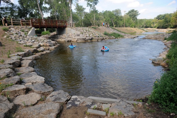
 Ann Arbor resident Carol Davis, center left, and her son Alexander, age 10, float in tubes near the bottom of the Argo Cascades. Angela J. Cesere | AnnArbor.com
/calendar/photologue/photos/!argocascades/cache/080412-AJC-argo-cascades-05_fullsize.JPG
Ann Arbor resident Carol Davis, center left, and her son Alexander, age 10, float in tubes near the bottom of the Argo Cascades. Angela J. Cesere | AnnArbor.com
/calendar/photologue/photos/!argocascades/cache/080412-AJC-argo-cascades-05_fullsize.JPG
-
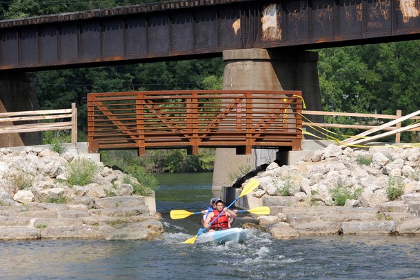
 Warren residents Josh Crowton, front, and Adam Bliznick, paddle in a kayak through the entrance to the Argo Cascades. Angela J. Cesere | AnnArbor.com
/calendar/photologue/photos/!argocascades/cache/080412-AJC-argo-cascades-06_fullsize.JPG
Warren residents Josh Crowton, front, and Adam Bliznick, paddle in a kayak through the entrance to the Argo Cascades. Angela J. Cesere | AnnArbor.com
/calendar/photologue/photos/!argocascades/cache/080412-AJC-argo-cascades-06_fullsize.JPG
-
 People kayak down the Argo Cascades near its entrance. Angela J. Cesere | AnnArbor.com
/calendar/photologue/photos/!argocascades/cache/080412-AJC-argo-cascades-07_fullsize.JPG
People kayak down the Argo Cascades near its entrance. Angela J. Cesere | AnnArbor.com
/calendar/photologue/photos/!argocascades/cache/080412-AJC-argo-cascades-07_fullsize.JPG


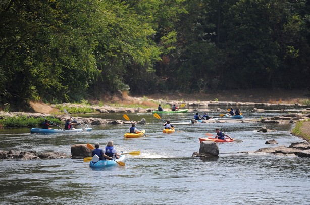
After being closed for a week, the Argo Cascades Saturday were once again thrilling kayakers and folks who chose to float down the Huron River in Ann Arbor in inner tubes.
"Some people still think the Cascades is closed," said Joe Wilhelme, who works for Ann Arbor's Parks and Recreation Department at the Argo Canoe Livery. "We're busy but we might be even busier had it not closed for that week. A lot of people know that the water is low."
Ann Arbor officials closed the Cascades, a series of drop pools separated by rocky formations, July 26, because of low flow conditions caused by this summer's drought. The river was at its lowest level in 10 years, according to staff members at the park.
The levels recovered enough to reopen the Cascades by Thursday, and Saturday kayaks and inner tubes were moving at a pretty good pace.
"I counted nine rapids," said 10-year-old Alexander Davis of Ann Arbor, who was tubing on the Cascades with his mom. "I like getting wet and really liked the big drop at the end."
"The rapids are fun but it was kind of slow in between," said his mom, Carol Davis.
The cascades have been a popular recreation spot since their opening earlier this year. The city spent $1.17 million constructing the kayak feature and recently approved a contract to lease 40 extra parking spaces at nearby property due to the popularity of the site.
The Mazzone family of Clarkston, who were tubing on the river Saturday, said the Cascades were worth the hour-long drive.
"We found it on line and just the pictures made us want to come," said Rick Mazzone.
Also tubing were Fran and Mark Coley of Ann Arbor who had scoped out the area the night before.
"They did a nice job setting this up," said Mark Coley.
Josh Crowton and Adam Bliznick came from Warren to kayak on the Argo Cascades.
"It's worth the trip to come out here," said Bliznick. Crowton said he was enjoying the workout.
A group from the Sunset Church of Christ in Taylor was also enjoy kayaking on the Cascades. "This is great," member Jesse Gilmer said. Her kayaking partner Antoinette Hill added, "It's really cool."
Wendy Ogilvie was visiting from Grand Rapids to get ideas to create a similar setup on the Grand River.
"I've been following the progress on Argo," said Ogilvie. "I like what they've done here. We have even bigger rapids on the Grand River and want to build something similar that allows canoes, kayaks and boats."
Canoes were not being rented at the Argo Livery for the Cascades, so James Blackburn of Saline brought his own.
"I've been here before and even though the water's a bit low, it's a normal flow," said Blackburn, who checked out the flow rate on a gauge mounted on the Broadway bridge as well as on a government website.
"They rate the river in cubic feet per second," said Blackburn. "The typical August flow rate is 150 cubic feet per second. In the springtime when the snow melts and the rains are heavier, it can go up to 2,000 cubic feet per second. That's when my friends and I love to make the Argo Cascades a destination."
Lisa Carolin if a freelance reporter for AnnArbor.com.
Comments
Rork Kuick
Wed, Aug 22, 2012 : 12:52 p.m.
River levels in Ann Arbor were crazy again, Aug 19-20, with lows well below 100 cfs and highs about 900 cfs. It's a factor of ten. You call that run-of-the-river? I don't see behavior of Allen Creek or upper river being able to explain that. Could a reporter please ask why this problem is continuing in a town chocked full of engineers, and what the plans are to fix it. I question whether Ann Arbor deserves licenses to run these dams, given these performances.
hmsp
Mon, Aug 6, 2012 : 2:26 p.m.
@ amlive, re trying Mill Creek: I put in at the High School once when the HCMA wouldn't allow put-ins because of too-high water levels. Unfortunately, when they took out the dam, they didn't consult with hydrologists, they just filled in the riverbed with large, angular rubble. The result is a lot of rough water, and angular waves, but no recognizable whitewater features under the bridge in Dexter. I have heard rumors that there is talk of remodeling that stretch for better flow, more eddies, and at least one, distinct, downstream Vee, but I don't think anything is planned for now. For now, the only whitewater around here is the Delhi Rapids when the Huron is running high. With three distinct channels, and sometimes even a fourth at far river right, it provides plenty of opportunities to catch eddies, surf, and eddy-hop. Two other single-drop play areas, one at the site of the old mill at the Burns-Stokes Preserve, and the other at the end of the Osborne Mills oxbow, are good places to practice ferrying and surfing. The latter is a favorite spot when extreme high water washes out the features at Delhi. And @ newsboy, re: "Open sewage kayaking is the bomb!" Yeah, that is a problem. An early proposal for the now-DTE whitewater included a peninsula that would extend downstream, protecting paddlers from the Allen Creek effluent. The current plan just dumps all of that toxic water straight into the whitewater area. That water should at the very least be re-routed as originally proposed. Better still would be to build in a settling pond at the DTE site as part of the cleanup. I think that the HRWC is in favor of this.
newsboy
Mon, Aug 6, 2012 : 1:51 p.m.
Open sewage kayaking is the bomb! I thought only cool places like Mexico, China and New York had this kind of fun!
ribs1
Mon, Aug 6, 2012 : 4:15 a.m.
Fine piece of investigative reporting here.
hmsp
Mon, Aug 6, 2012 : 1:38 a.m.
Many of us in the paddling community cringe at the fact that this novice bypass around the dam is still being marketed as a whitewater feature, when it was designed as exactly the opposite. And aa.com, starting, I believe, with Ryan Stanton, and now, unfortunately, Lisa Carolin, has enthusiastically taken up the cry. Actual whitewater provides canoeists (kayakers, too) the option of working their way upstream by taking advantage of strong upstream currents created by rocks, bends in the river, etc. There's nothing like that in the grandiosely-named "Cascades." And these extremely narrow chutes contain no waves that can be surfed — they were designed only to funnel boats down to the next lower level, while using the absolute minimum amount of water, to keep the whole thing novice-friendly. When the yet-to-be-approved whitewater construction just below the dam was designated as a future project, to be built at some later date by DTE, the novice bypass suddenly started getting touted as the "Argo Cascades." We have long worried that this is a distorted PR campaign, designed to soften the blow if the previously-promised whitewater gets rejected in the end by the DEQ. DTE is still proposing to build that actual whitewater — hopefully they plan to use higher quality construction than the obviously-concrete-water-park "Cascades" — but the permit has yet to be issued. The DNR and DEQ previously came down emphatically in favor of removing Argo Dam, and restoring the river to something a tiny bit closer to its original, free-flowing, state. The promised whitewater, and the novice bypass, were a deciding factor for many of us in the paddling community who wanted to see the dam removed, but realized that we were no match for the highly-organized-and-funded rowing community, and threw in our free-flowing towels. We've had plenty of the fluff stories, perhaps now aa.com could report in depth on this topic, as they have been asked to do many times on thes
amlive
Mon, Aug 6, 2012 : 2:57 a.m.
I tried one more time to give kayaking in Cascades D'Argo a shot on Saturday, and did find one wave in one chute that was just enough to hold my attention for about 2-3 minutes in attempts to clime the chute. Unfortunately the chutes are so shallow you can't even get 6" of paddle to grip the water with. In my 20 years or so of paddling I've always written off tubers as an annoying nuisance to be tolerated on rivers. Alas, the Cascades have left me resigned to stick my own rear in a tube and sit back and enjoy the ride. They are a completely disappointing destination for canoes or kayaks, but they're good for taking the kids down on a hot afternoon to cool off and play on the slides. Even if DTE does manage to build some whitewater features, I wouldn't hold your breath in hopes of anything big. Everyone's too afraid of liability with the livery right there. I haven't tried Mill creek in high water, but it looked interesting this spring. Then Grand Rapids may hold some hope with it's potential plans to remove some dams. And of course removal of three dams on the Boardman river should be starting soon, so we'll we what happens there. As for the Huron in Ann Arbor though, I doubt we'll ever see rapids enough to be a destination for anyone but tubers and sit-on-top livery kayaks. There's just too much emphasis on rowing clubs, livery rentals, and liability protection to expect anything else.
OLDTIMER3
Sun, Aug 5, 2012 : 11:09 a.m.
The picture shown is a canoe not a kayak, so heradline should say canoest.
amlive
Sun, Aug 5, 2012 : 2:42 p.m.
It's a newer breed of boat called a "sit-on-top kayak". I know, the lack of any deck kind of brings the accuracy of the name in to question, but that's what they're called.
OLDTIMER3
Sun, Aug 5, 2012 : 11:10 a.m.
oops, headline
amlive
Sun, Aug 5, 2012 : 4:38 a.m.
As to opening the Cascades vs closing them to increas flow through the dam, here's what confuses me - given that neither section is a "natural" waterway, or at least the original virgin path of the Huron, how is one determined to be more important than the other? That whole section from the dam to Broadway is an altered artificial river path. The original course swept a wider curve through what is now the DTE property. Of course there's really not much original streambed from Maple road through Belleville, but my point here is that the lower section parallel to the Cascades is no more original than the Cascades, but just modified a hundred or so years earlier. So as long as the sum of water flowing downstream out of the pond is the same, how does the section below the berm earn priority over the Cascades? In spite of being one who uses the pond several times a week, I still wish they had just pulled the dam out when the opportunity was there. Since we seem to be stuck with it for a while now however, perhaps this drought should be a wake up call to rethink the developments associated with the DTE property cleanup. I understand they were planning I put two additional drops on the river side - perhaps these should include some degree of water level control in their design. With one in place above the Cascades reentry we may at least be able to keep the riverbed from drying up during drought, while still keeping the Cascades flowing. Placing the second barrier below the Cascades could maintain a minimum water level to keep that last drop from getting so extreme. In high water these barriers could be fun play spots for kayakers, and in low water they may work as little more than a stepped extension of the pond. Maybe not the perfect solution, but seems like it would alleviate the problems with use of the Cascades and water levels immediately below the dam, at least until levels drop below 60-80 cfs
ribs1
Sun, Aug 5, 2012 : 7:32 p.m.
I like your points. I disagree that the cascades are the new river. The cascades have an artificial bottom. Probably not conducive to spawning, or hosting mayflies, stoneflies and caddis. The river channel has been what it is for long enough that it is a real river bottom where it is now. There should be a minimum flow rate over the dam. I have no problem with the cascades in fact I think it makes a cool feature. However, the cascades should be closed anytime the flow rate over Argo dam is less than 100cfs.
amlive
Sun, Aug 5, 2012 : 7:04 p.m.
Thank you by the way, ribs1. I may have a slightly differing perspective from you, but have had to concede to at least some of your points so far where your knowledge of the system has bested mine. I still have my opinions, but take your input seriously and with great welcome.
amlive
Sun, Aug 5, 2012 : 6:59 p.m.
I guess I've not done as well there, though I haven't fished it as much as other sections. Caught smallmouth and rock bass, seen catfish, carp, and bluegill or crappie, but haven't focused on this area as much. I take your point, but still, now that the Cascades D'Argo is there, it Has already started to become a valuable part of the ecosystem as well. I know that fish are moving through it, as I've caught much better smallmouth in those pools than I have in the river. I'll concede that tha constant human disturbance (and the muddy bed) probably won't serve any good for spawning, but it is still a part of the system now. Plus, with the sludge coming from Allen creek, I don't know that closing the Cascades during this drought would have even saved the river life in this drought. Maybe, but it still would have been pretty dangerously low at best. I hear your points, which are all reasonable and valid no doubt. Still, given what we have to work with now (and since the DTE project is slated to include some river modification anyway), I think it should be worth looking at making the new river features include some sort of minimum level control until below the Cascades. If designed wisely the river could still run at good current during normal flow, and though current would be reduced to almost still during drought, at least it would be less prone to drying up to where it is now. It may not be ideal, but I think "ideal" (ecologically speaking) went out the window when we/they decided to keep the dam in. We're going to have to deal with what we have now, and to me this seems like a pragmatic compromise. I would love to see someone from the city or PAC chime in here, or perhaps write a guest column to fill us in on their current thoughts and plans.
ribs1
Sun, Aug 5, 2012 : 3:58 p.m.
amline, This was a thriving ecosystem. The first 1/4 mile below argo dam was probably the best section or river that flows through the city. Before this happened the fishing was great. This area was full of small mouth bass, catfish, bluegills, and rock bass. In the spring lots of walleyes ran up to the dam in this area. The water was well oxygenated and a little cooler than the rest of the river. Also, the gravelly bottom contained tons of aquatic insects. Mature trees provide lots of shade and logjams creating hiding spots for the fish. Have you ever fished this section? Now the fish are gone.
amlive
Sun, Aug 5, 2012 : 4:48 a.m.
Then of course there's permits. I recall some talk of uncertainty as to whether the State would allow these barriers in the river section below the dam. I don't see what the problem would be, because (A) it's not a "natural" streambed to begin with, and (B) it's hardly a thriving or unique ecosystem worthy of protecting in it's current state anyway. Then again I have no idea what criteria the State looks at in these situations. Which brings me to another point - when is DTE going to start on this cleanup? The riverbed has been nearly dry for over a month, and if they don't start soon they are passing up on the most ideal circumstances imaginable in which to excavate and fill the areas they need to.
Russ Miller
Sun, Aug 5, 2012 : 3:05 a.m.
"So, since there hasn't been any rain, and the area has had high temperatures since the closing, why is the river higher now? What changed?" It did rain to the north of Ann Arbor on July 26th and even more on the 27th - Kent Lake level AND outflow rose sharply on those days then peaked on July 28. Flow rose and peaked downstream at Hamburg on July 30 and at the Ann Arbor Gauge on July31-Aug 2.
Epengar
Sun, Aug 5, 2012 : 8:45 p.m.
Flow over Barton Dam changed. The Ann Arbor Chronicle has detailed coverage: http://annarborchronicle.com/2012/08/04/how-low-can-argo-flow-go/
Russ Miller
Sun, Aug 5, 2012 : 5:51 a.m.
I'm just answering JRW's question - If it hasn't rained why is the river higher. Ok?
ribs1
Sun, Aug 5, 2012 : 3:46 a.m.
So what is your point? Ann Arbor Gauge peaked 2 days ago and is on the decline. All the other gauges on the river especially the New Hudson gauge are on the decline. So why would they open the cascades now?
ordmad
Sat, Aug 4, 2012 : 7:46 p.m.
I love how people vote down Kea's factual correction. What could possibly motivate that?
JRW
Sat, Aug 4, 2012 : 7:44 p.m.
So, since there hasn't been any rain, and the area has had high temperatures since the closing, why is the river higher now? What changed?
Mohawk
Sat, Aug 4, 2012 : 11:46 p.m.
I went today and they said more water was released from the dams....it was very enjoyable today
ribs1
Sat, Aug 4, 2012 : 9:36 p.m.
There has not been significant rain upstream. The gauge at New Hudson reads 10cfs which is lower than the all time low (17cfs) The ann arbor gauge reads 93cfs which is still far below normal and lower than last week. 60cfs goes through the cascades leaving only 33cfs going over Argo Dam. The cascades should be completely closed any time the river is below 160cfs as the minimum flow over the dam should be 100cfs.
JPLewis
Sat, Aug 4, 2012 : 8:18 p.m.
There has been rain up-river from Ann Arbor, so the river has gotten a bit more flow.
Kea
Sat, Aug 4, 2012 : 7:28 p.m.
"the city spent $1.17 million constructing the kayak feature" Actually, only a small part of the $1.17 was for the kayak feature.