
Severe weather online: checking the progress of storms as they roll by
As the storms came into the area yesterday, my boys were playing in the yard. Everyone came in for lunch and to check the weather. I knew it was probably going to rain, but wasn't sure exactly when, and wasn't sure exactly how severe the weather would be. At some point, weather might be bad enough that we can look forward to a trip to the basement and a test of all of our battery-backed communications gear.
Here's what I followed online to see how things were going and to assess the progress of the storms. Every year, there's a little more weather information online, as technology that was once only available to professionals works its way into public web pages.
Weather radar
The best first look at weather can be seen from the AnnArbor.com weather page, which brings in data supplied by the Weather Underground. Weather Underground is a company with offices in Ann Arbor that started from online weather efforts in the 1990s originally from the University of Michigan's Space Physics Research Laboratory.
Severe weather alerts
If there is a severe weather alert, the National Weather Service will issue a statement and update it as frequently as necessary to warn the public about a fast-moving storm. This Current Severe Weather for Washtenaw County page from Weather Underground has the text of that warning.
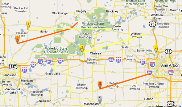
Storm tracking is not an exact prediction effort; some storms will change direction and speed unexpectedly. Here are four sequential predictions from yesterday to give you an idea of how one early Monday afternoon storm changed course:
- First prediction: Manchester 12:45 p.m., Bridgewater 1:05 p.m., Chelsea 1:15Â p.m.
- Second: Clinton/Manchester 12:30Â p.m., Pleasant Lake 12:40Â p.m., Bridgewater 12:45Â p.m., Saline 12:55Â p.m., Pittsfield/Ann Arbor 1:05Â p.m., Whittaker 1:10Â p.m.
- Third: Saline 12:55 p.m., Pittsfield Township 1:05 p.m., Ypsilanti and Whittaker 1:10 p.m.
- Fourth: Severe Thunderstorm Warning for northeastern Lenawee and Washtenaw counties expires 1:15Â p.m.
Lightning tracking
One of the dangerous elements of a severe storm, and one that is likely to cause damage to the power grid, is lightning.
A few years ago, web-based real time lightning information was really hard to find. Now it's getting easier. One source I found yesterday was StrikeStar, which has a detailed 60-minute and 24-hour mapping of lightning strike locations nationwide. Subsequent searching turned up Vaisala and USPLN as other data sources; more detail is worth exploring before the next storm.
Where do storms track in from?
If this were a typical storm, then the conclusion you would draw is that you have to watch the weather in Manchester to see what it's going to be like in Ann Arbor. More generally, though, the prevailing winds bring storms from west to east, and if you are going to look at adjacent counties for signs of weather then you want to also check out weather from Lenawee, Hillsdale, Jackson, Ingham and Livingston counties.
Area tornados, 1950-2009.
Tornado History Project
The Tornado History Project collects tracks and severity of historical storms dating back to 1950. Its historical tornado map for Washtenaw County show that the small number of tornados that have hit the county (only six in 60 years) generally have tracked from in from the west or the west southwest.
After the storm: flooding
Sudden downpours can bring flooding. I wrote quite a bit about rain and river maps and gauges a few weeks ago, which has useful links worth relinking to.
Different rivers respond differently to sudden rainstorms. The USGS Waterwatch Explorer is a nice way to browse that data, showing at a glance which rivers are well above their normal levels. It can also bring you observations like the sudden rise of the River Rouge at Inkster, which went up 3 feet in the matter of a few hours during the storm. The Rouge is nowhere near flood levels, but that's still good to know that if you're near that river during a storm, as there may be rapid water level changes.
Edward Vielmetti chases storms from the safety of his basement for AnnArbor.com. Contact him at edwardvielmetti@annarbor.com.
Comments
jns131
Wed, Jun 2, 2010 : 12:10 p.m.
You can get weather bug for free. It chirps me when the weather gets nasty as I am on line or I believe they can send stuff like that to your cell phone. Not sure. But I do know that today and tomorrow is suppose to be nasty.
Your Neighbor
Wed, Jun 2, 2010 : 9:01 a.m.
Dear Edward Vielmetti, You've been unselfishly explaining how things work to your online community since the days of MTS and Confer. Thanks for this explanation of the weather maps available on the Internet, particularly for the starstrikeus.com resource. I saw the storm coming via this website, and now it seems to have passed us by. Very useful and enjoyable information. Thanks.
treetowntenor
Wed, Jun 2, 2010 : 8:38 a.m.
If you have access to a radio scanner, you can listen to the county "Skywarn" network on 145.15MHz. You'll hear weather spotters giving real-time severe weather reports from around the county.
Ignatz
Tue, Jun 1, 2010 : 10:47 a.m.
Intellicast.com has some nice radar apps.