
Ann Arbor escapes brunt of winter storm; winter weather advisory in effect
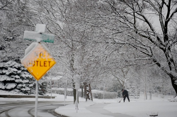
A man shovels the sidewalk on Suffolk Street off Stadium Boulevard in Ann Arbor on Friday morning.
Melanie Maxwell | AnnArbor.com
- Related story: Crashes reported in wake of overnight snowfall
- Related story: Washtenaw County school closings.
The Ann Arbor area escaped the brunt of a winter storm moving across southeast Michigan, the National Weather Service said Friday.
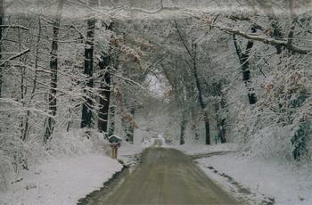
Friday morning's snowfall created this winter-wonderland scene on Conway Road near Chelsea.
Courtesy photo
Total snowfall for the area is now expected to range from 2 to 4 inches. An additional 1 to 3 inches could fall this morning on top of the 1 to 2 inches that fell overnight. Some rain and sleet could mix in with the snow, said meteorologist Steve Considine.
The snow had tapered off in the pre-dawn hours but was expected to pick back up later this morning, forecasters said.
Still, the morning proved challenging for Ann Arbor-area motorists as several crashes were reported on area roads.
Drivers will find mostly wet conditions on the main highways in Washtenaw County, said Jim Harmon, director of operations for the Washtenaw County Road Commission said at 5:30 a.m. Primary roads may have some residual snowfall. Secondary roads have not been plowed, but crews hope to get to those this afternoon, Harmon said.
The Road Commission called in its full crew of 46 trucks at 4 a.m., Harmon said. He advised motorists to allow extra travel time, reduce speeds and leave plenty of space between vehicles.
Areas to the north of Flint are now expected to receive the highest snowfall totals, up to 8 inches, Considine said.
Few problems were reported on Washtenaw County roads overnight, a dispatcher with the sheriff’s department said.
Several Washtenaw County schools had called off classes for the day.
For updated forecasts and conditions anytime, check AnnArbor.com's weather page.
Comments
J. A. Pieper
Fri, Feb 24, 2012 : 10:58 p.m.
I could have predicted this winter, didn't buy a snow blower, but I did by a snow rake for my roof. It is all ready to go, but I am thinking I will soon have to take it apart to store it for spring/summer. Now, what can I buy during the lead in to the next winter? This always works for me!
julieswhimsies
Fri, Feb 24, 2012 : 7:58 p.m.
Why do we have to be advised by the Weather Service that winter weather is coming? It IS winter, isn't it?...Well, sort of, I guess.
Pizza Man
Fri, Feb 24, 2012 : 6:21 p.m.
Did anyone notice all the salt trucks that were our salting the roads last night? They even did my neighborhood. Was it just me or did the county not do anything the last time is snowed? Were they just trying to spend money that they didn't need to? It seemed like they were trying to make up for the last snow by getting out and salting early.
ogel1209
Fri, Feb 24, 2012 : 7:37 p.m.
They did nothing the last time it snowed.
a2friend
Fri, Feb 24, 2012 : 6:09 p.m.
Darn it! I was hoping to use my hand crank radio at least once this winter......
townie54
Fri, Feb 24, 2012 : 5:55 p.m.
Like I said yesterday,all you had to do was look at the high temps for the next five days on every weather service there is.They all said 35 or above so duh,you knew it wouldnt stick
MIKE
Fri, Feb 24, 2012 : 5:11 p.m.
Someday, we'll be telling our grandchildren about "The Blizzard of '12".
amaizinblu
Fri, Feb 24, 2012 : 3:37 p.m.
I believe back in the day there was Dick the Bruiser who helped co-host on WRIF radio. He said with respect to snowfall predictions that if they gave a range you pick the lower number and cut it in half and that would be the amount we would actually get.. Ex. 4 to 6 inch snowstorm would yield about 2 inches in actual accumulation. I believe he used to call it the Dick Factor. Almost without fail he seemed to be accurate.
N. Todd
Sat, Feb 25, 2012 : 4:10 p.m.
I don't know who Dick the Bruiser is is, and don't listen to the WRIF, but I think the guy was on to something. I recently developed my own formula, where you simply subtract one additional inch at the end. (It's posted as a reply to zeeba's post at 8:33) And yes, it has been quite accurate this year.
Tom Joad
Fri, Feb 24, 2012 : 3:06 p.m.
Promised a storm, delivered wet sidewalks
joe golder
Fri, Feb 24, 2012 : 2:51 p.m.
4 to 6 inches over a 20 hr span with mild temps is an advisory! Even when we were only going to get 2 inches this year the news pumped up the fear machine! I can't wait to see what they report during the upcoming presidential election.
MRunner73
Fri, Feb 24, 2012 : 2:41 p.m.
The local National Weather Service Office really blew it. I was shocked they even mentioned thundersnow. In the winners and lowers catagory: Accu Weather had the best forecast and the NOAA folks did the worst. The storm track was such that the heaviest snow in West Central MI. The storm only produced 8 inch amounts in parts of Iowa and Wisc.
jns131
Fri, Feb 24, 2012 : 2:36 p.m.
If you all want snow, then go north. I heard the UP is socked in and won't be digging out until May. As for us? Snow, warm air and more rain this weekend. Beginning to sound like the makings of a movie I just watched. All water and no land.
julieswhimsies
Fri, Feb 24, 2012 : 8:28 p.m.
The UP is not "socked in" I just talked to my brother, who lives in the central UP...off a logging trail. He's a surgeon. He said it's business as usual up there. Yoopers are always prepared for more snow.
David Cahill
Fri, Feb 24, 2012 : 2:34 p.m.
I'm also really tired of AnnArbor.com's constantly crying wolf over weather "forecasts" that turn out to be wildly wrong. I suggest that AnnArbor.com post a prominent notice on top of each weather story saying that the accuracy of weather forecasts is not good, and that the forecasts should not be relied on.
Ross
Fri, Feb 24, 2012 : 10:31 p.m.
Don't you know that yourself though? Why should they have to put an idiot-proof disclaimer on a news article about a "prediction". It's never guaranteed.
amlive
Fri, Feb 24, 2012 : 2:18 p.m.
I'm convinced that one of Moses' descendants must be living somewhere around Chelsea. Whenever a good storm comes along I'm guessing they pull out the old staff to play with (apparently it works on clouds as well).
dexterreader
Fri, Feb 24, 2012 : 1:59 p.m.
Next time we won't tell you or give any advance "warnings". Then you'll all be mad because we didn't tell you. I'd rather be prepared than surprised. But that is just me.
Ross
Fri, Feb 24, 2012 : 10:30 p.m.
Lumberg, who has "fear" of a modest snowstorm? I was excited for some decent snowfall, personally. And kind of disappointed it didn't materialize.
lumberg48108
Fri, Feb 24, 2012 : 4:58 p.m.
Read my posts and then tell me I am wrong - warnings are fine - weather crawls are fine --- its 2012 who the heck does not know when snow is coming in Michigan? endless pre-storm hyperbole that serves no purpose other than to create fear - what do "we" think of that?
justcurious
Fri, Feb 24, 2012 : 2:05 p.m.
Who is "we"?
lumberg48108
Fri, Feb 24, 2012 : 1:50 p.m.
As I posted yesterday, this hyperbole regarding "storms" by local (and other media) needs to end. I understand the 24 news cycle leads to this but please, snow is not news in Michigan in the winter! Today there are a few inches of slush and I wore a fleece --- is this the new new headline for annarbor.com? as javajolt1 typed -- please stop!
zeeba
Fri, Feb 24, 2012 : 5:41 p.m.
lum- If you look at the past three days, the coverage consisted on one article in the morning and an update in late afternoon. There also was one story about how the road commission handles snowstorms that looks like it had been in the can all winter and this was their first chance to use it. There was also an article about the possibility of thundersnow, which is an usual occurrence. You also have to take into account we've had very little snow this winter, which made this approaching event more newsworthy than usual. As for the articles, they consistently predicted a snowfall total of 4-6 inches, with the possibility of more if the storm took a southerly track. If it had done that, it would have been a major storm, so they were right in altering people to the possibility. Sorry, but I think the outrage is all about people who don't read beyond the headlines.
lumberg48108
Fri, Feb 24, 2012 : 4:24 p.m.
@zeeba you hit the nail on the head - NEWS --- not hyperbole and predictions based on (relatively) small amounts of snow and endless stories that run BEFORE the snow never comes... this is a late winter sleet arrival - not a storm and all the posturing wont change that fact
zeeba
Fri, Feb 24, 2012 : 2:03 p.m.
We're due for another 1-3 inches today - the forecast here was for a storm total of 4-5 inches through this evening. If you don't want a weather forecast, then stick to Angry Birds and leave the news sites to those of us who want to know what's going on.
xmo
Fri, Feb 24, 2012 : 1:46 p.m.
I left my car idling last night to create more "Green House" gases and that is why we didn't get the big snow fall. I guess I just proved Man Made Global Warming!
gofigure
Fri, Feb 24, 2012 : 2:02 p.m.
LOL. Your comment got my day started with a chuckle. Thanks!
zeeba
Fri, Feb 24, 2012 : 1:33 p.m.
It' pretty hard to predict exactly where a storm will track - but you'll not this storm did dump eight inches of snow in some areas, they just turned out to be around Flint. Also, the reports I saw yesterday were predicting heavy snow for west and mid-michigan, with about 4-5 inches predicted as the most likely outcome here - which is turning out to be spot-on. The NWS lets you know when there's a good chance that a really heavy snowfall may track through your area, so you can be prepared. You folks may be whining about it this morning, but I bet the folks north of Flint appreciate the heads-up. It's not an exact science, but they give you the best warning they can. Grow up and quit complaining.
N. Todd
Sat, Feb 25, 2012 : 4 p.m.
@zeeba - This might not go over well after-the-fact, but I stand whole-heatedly by my comment. I have made up my own formula, which still relies on traditional meteorologists, but is somewhat more accurate. When they give a range of accumulation, I take the mean, divide by two, and subtract one. Ex. - 6-10" expected. Mean=8. 8/2=4. 4-1=3". You should actually expect 3" of snow, not 6-10". I understand this method is completely unscientific, but it has been surprisingly accurate (this winter, at least); much more so than what the media forecasts.
Ross
Fri, Feb 24, 2012 : 10:28 p.m.
hear hear! Finally some common sense.
zeeba
Fri, Feb 24, 2012 : 2:33 p.m.
Todd - but like I said, the forecast for Ann Arbor was 4-5 inches by tonight!!!! We're supposed to get several more inches today, so that would be spot-on!!! Frankly, I think people weren't paying attention and just assumed the whole thing was supposed to fall last night.
N. Todd
Fri, Feb 24, 2012 : 2:24 p.m.
@zeeba - I think you're right that many people do have an interest in the weather forecast, especially when it might effect travel, work, etc. However, the weather reports I have seen prior to any snow falling this year have been horribly inaccurate. From my recollection, we have seldom seen 50% of the 'expected' accumulation. Quit reporting 5 to 8 inches for a 2 inch snowfall. I would rather have a broader range (2 to 8 inches) than just wrong information. I understand they can't predict the future but I have to believe the numbers get bumped up to help instill a little extra fear in our community, which seems to welcome it.
zeeba
Fri, Feb 24, 2012 : 2:11 p.m.
You're saying there are no school closings today? I beg to differ. The reason they keep repeating weather stories is that 1) there is strong interest in them, despite the griping of people like yourself 2) it's information people need to know, and not everybody is monitoring their TVs nonstop, so they do frequent reports and 3) it's a developing story, so it's regularly updated as the predictions are refined as the event gets closer. Like I said, grow up and quit complaining.
lumberg48108
Fri, Feb 24, 2012 : 1:53 p.m.
A heads-up? Of course! Weather services are created for this purpose. Crawlers on TV stations and a story is warranted. Endless predictions and early stories of possible costs and damage or closings in the days ahead? Not needed and we all know it!
Halter
Fri, Feb 24, 2012 : 12:45 p.m.
Actually...I had an accurate prediction YESTERDAY of the limited snow, that was direct off of the meteorology charts and indicating how the low pressure cells currently make it impossible for A2 to get heavy snow...and I posted that on the primary "sky is falling" article which A2.com was then fast to defend their own prediction. Likewise, a friend who used to be a meteorologist at Fox and quit there recently also posted that same information both at Fox and here... Weather sensationalization increases tv viewership and dotcom readership = increased advertising revenue. It's why he quit at Fox.
Brad
Fri, Feb 24, 2012 : 1:22 p.m.
It wasn't AA.com's prediction, it was the National Weather Service's. Take it up with them. And people guess correctly all the time. So what? Some number of amateur predictors probably predicted 6' of snow as well - they're just not writing in today.
Craig Lounsbury
Fri, Feb 24, 2012 : 1:19 p.m.
I believe your prediction was.... "All current reports (9:15 pm) are stating perhaps an inch or two thursday night NORTH of Detroit (that does not include Ann Arbor) and that it will all be melted by Friday afternoon...." It seems clear we won't get the snow levels predicted but I wouldn't yet say your prediction was "accurate" . Lets see if its all melted by this afternoon.
Buster W.
Fri, Feb 24, 2012 : 1:14 p.m.
Nothing more hilarious than Justin and Rich during a thunderstorm warning. They would go back and forth drilling into various "cells" and looking for possible tornadic rotation. Comical!
Another Michael
Fri, Feb 24, 2012 : 12:25 p.m.
We apologize: Snowpocalypse has been cancelled due to rain. Please stop by the box office for a refund.
Barzoom
Fri, Feb 24, 2012 : 12:21 p.m.
I wonder why it is that when it snows, the county has the major roads plowed and salted, while in the city of Ann Arbor they remain untreated, ice and snow covered.
leaguebus
Fri, Feb 24, 2012 : 5:39 p.m.
@Sallyxyz, I complained to the city about getting stuck going up a hill in my neighborhood. It was the storm we had on a Friday about 3 or 4 weeks ago. They didn't touch the streets in my neighborhood, northwest side. I was sent an email after my complaint that they did not do anything because it was just going to melt in first few days of the next week. For me, Saturday and Sunday were a mess as the roads were all ice. They would not even come through with a plow blade down because they only do it for 4" or more and this was 2". Well at my house it was 4".
Sallyxyz
Fri, Feb 24, 2012 : 1:48 p.m.
Because it will all be melted anyway by the afternoon, so what the heck, drivers can slip and slide in the morning. No problem!
Sallyxyz
Fri, Feb 24, 2012 : 1:46 p.m.
Because the city doesn't treat roads with salt or plow any more. They spent the road maintenance money on public art.
tdw
Fri, Feb 24, 2012 : 12:20 p.m.
Has anyone heard the phrase " don't shoot me I'm only the piano player ". This " storm " was all over the network news yesterday.
javajolt1
Fri, Feb 24, 2012 : 12:15 p.m.
Hype, hype, hype....then....nothing. This is getting old. Its one thing to report a pending snowstorm The National Weather Service has predicted. It is another to feed the fire by printing a dozen stories in advance of its arrival. Please stop. We can look out the window.
Ross
Fri, Feb 24, 2012 : 10:24 p.m.
This website only relies on data from the national weather service. Complaining about their snowfall forecast predictions is completely asinine. With all the free data and weather prediction services we have now, people could try taking some personal responsibility for predicting weather. It's really not that hard. No one hyped anything, they only said we would get 4-7" of snow, and then we got 3. That's not too far off and nothing to cry about.
Halter
Fri, Feb 24, 2012 : 12:40 p.m.
Actually...I had an accurate prediction YESTERDAY of the limited snow, that was direct off of the meteorology charts and indicating how the low pressure cells currently make it impossible for A2 to get heavy snow...and I posted that on the primary "sky is falling" article which A2.com was then fast to defend their own prediction.
Brad
Fri, Feb 24, 2012 : 12:18 p.m.
Looking out the window only works for "postdicting" the weather like everyone is doing today.
btee
Fri, Feb 24, 2012 : 11:56 a.m.
Im so sick of going to bed in the afternoon preparing to get up in the early am to work.. Im ready to retire the plow for the year and i have barely used it this year.. :(
UtrespassM
Fri, Feb 24, 2012 : 11:36 a.m.
Another "the wolf is coming".
Homeland Conspiracy
Fri, Feb 24, 2012 : 2:40 p.m.
Little Red Riding Hood.....try the boy who cried wolf. Myself I like to say over & over "The Sky Is Falling"
jns131
Fri, Feb 24, 2012 : 2:32 p.m.
Little Red Riding Hood? I told you not to go home.
Craig Lounsbury
Fri, Feb 24, 2012 : 11:28 a.m.
So can I return the 6 weeks of emergency supplies I bought yesterday?
Ross
Fri, Feb 24, 2012 : 10:22 p.m.
Sure.... did someone from annarbor.com instruct you to do that?