
New winter storm forecast: 3 to 4 inches of snow expected in Ann Arbor
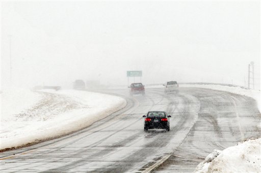
Vehicles travel west along highway US 50 in South Hutchinson, Kan., Monday as blizzard conditions hinder visibility. The same storm that caused blizzards in Texas and the Plains states is moving into Ann Arbor, but warmer air temperatures here will keep snowfall totals down, forecasters said.
AP photo
- Updated: New winter storm forecast: 3 to 4 inches of snow expected in Ann Arbor
- Related: League championship basketball games postponed due to weather; hockey playoffs still on
- Crashes already affecting Washtenaw County roads as winter storm rolls in
Forecasters have lowered the expected total snow accumulation from a winter storm moving into the Ann Arbor area.
With temperatures expected to hover above freezing for much of the day Tuesday, forecasters now say the storm will drop about 3 1/2 inches of snow on Ann Arbor by the end of the day Wednesday. Another inch could fall Wednesday night. Earlier forecasts had called for about 6 inches or more. A winter weather advisory is in effect until noon Wednesday.
The weather service said a minor glazing of ice is possible on elevated and untreated surfaces Tuesday afternoon. The heavy, wet snow expected later could put stress on tree limbs and power lines, causing power outages.
Whatever happens, road crews are ready for it, said Jim Harmon, director of operations for the Washtenaw County Road Commission. Day-shift drivers will stay on Tuesday until 8 p.m., Harmon said. At that point, a four-person night crew will take over to focus on main trunk lines, such as Interstate 94 and M-14. The entire day shift will return at 4 a.m. to salt and plow.
Additional personnel could be called in overnight if conditions warrant it, Harmon said, but the goal is to use resources wisely and deploy drivers when they’re most needed for the morning rush hour.
Ann Arbor crews also are ready, said Kirk Pennington, field operations supervisor for the city. The city will have 10 people driving plow trucks from 6 p.m. Tuesday to 6 a.m. Wednesday, he said. They will focus on main thoroughfares in town. Starting at 6 a.m., the 10-person day-shift crew will start plowing and salting throughout the city.
The leading edge of the storm, which caused blizzard conditions in parts of Texas and the Plains states moved into the Ann Arbor area about noon Tuesday, a bit earlier than expected. Mostly rain is expected before 7 p.m., though some periods of mixed precipitation are possible, said Matt Mosteiko, a meteorologist with he National Weather Service in White Lake Township, which does forecasting for all of southeast Michigan.
Little accumulation is expected before 7 p.m., Mosteiko said. After the precipitation begins switching over to snow, about 2 1/2 inches is expected between 7 p.m. and 7 a.m. Almost an inch more could fall during the day Wednesday for a storm total of 3.4 inches, Mosteiko said. Another inch of snow is possible Wednesday night.
After the storm moves on, Ann Arbor will have a cloudy day Thursday with a high around 35. There’s a 30 percent chance of snow showers. Friday and Saturday also will be mostly cloudy with highs in the upper 20s. A partly sunny day is on tap for Sunday with a high of 26.
Harmon advised drivers who don’t have to go out on the roads Tuesday night to stay home.
“We’re gonna be out there, but if they have a choice don’t drive,” Harmon said. “ If they do have to drive, plan ahead; prepare for a longer travel time.” He noted visibility will likely be reduced and drivers should leave extra distance between vehicles.
He also requested that people avoid parking their cars on subdivision streets in the county Wednesday to allow snowplows to clear the streets. Keeping garbage cans out of the street will also be helpful, he said.
Ann Arbor is feeling the effects of the same storm system that created blizzard conditions in the Plains and Texas Panhandle. Amarillo got 17 inches of snow Monday, the Associated Press reported. Thousands lost power in Texas and Oklahoma. Winter storm warnings were still posted Tuesday for parts of Kansas, Missouri and Illinois.
For updated forecasts and conditions anytime, check AnnArbor.com's weather page.
Cindy Heflin is associate news director at AnnArbor.com. Contact her at cindyheflin@annarbor.com or 734-623-2572 or follow her on Twitter.
Comments
Nicholas Urfe
Wed, Feb 27, 2013 : 12:30 a.m.
Game over! Flee Ann Arbor while you still can, before it is wiped out.
jns131
Wed, Feb 27, 2013 : 3:34 a.m.
Snow apocalypse hits Ann Arbor. Stores wiped out of everything. Read about on aa dot com.
Loopy
Wed, Feb 27, 2013 : 12:21 a.m.
Lowered Expectations....
Cindy Heflin
Tue, Feb 26, 2013 : 11:35 p.m.
The National Weather Service issued a special statement at 6:03 p.m. warning of moderate to heavy snow showers across southeast Michigan. Visibilities could be less than one mile. Snowfall accumulations of a half inch to an inch per hour are expected during the next couple of hours. Full statement: http://forecast.weather.gov/showsigwx.php?warnzone=MIZ075&warncounty=MIC161&firewxzone=MIZ075&local_place1=&product1=Special+Weather+Statement
K32
Tue, Feb 26, 2013 : 11:32 p.m.
The roads were pretty bad at 5 o'clock. I'm less bothered by that than by what seems the constant threat of power outages. If it clouds over and looks threatening, the power goes out.
jns131
Wed, Feb 27, 2013 : 3:32 a.m.
Should have been on State street. O what fun it is to slip and slide.
Ann English
Wed, Feb 27, 2013 : 1:20 a.m.
I know, a power outage is something you don't forget about within a day. Just had a 100-minute power outage yesterday, but it interrupted a dishwasher cycle and shut off most of the phones. Cut off Internet access, too.
Tru2Blu76
Tue, Feb 26, 2013 : 11:20 p.m.
Haven't seen the usual U of M posting of "heaviest snow falls" yet but I remember Feb.25, 1965 very clearly. Detroit got only 11" but outlying areas got that much by sunrise and it kept falling during the day until many areas accumulated 17 inches. And it DRIFTED like crazy with some major roads clogged with 3 or more feet of snow. I remember deciding to try getting to work that morning - which was only 5 miles away, typically a 15 or less minute drive. It took me an hour and at points I had to drive around stalled and abandoned cars, using people's front lawns. I found the company parking lot covered in 30 inches of snow and some employees (there were 250) parked at the bar across the highway from the factory. That was on a Thursday. And the manager decided that the 30 people who managed to get through all that would be paid because they couldn't operate the factory with that few people. So - almost everyone stayed home the next day, Friday. It wasn't a whim, either, many major roads were still limited to one lane with snow reaching the door handles on cars. The only worse snow storm I remember came just days before I moved to Ann Arbor: Dec. 1-2, 1974. Detroit got an "official 19.2" but Ann Arbor got "a bit more." Never seen anything like it since.
Tom Joad
Tue, Feb 26, 2013 : 10:42 p.m.
Couple of streets to avoid: West Washington going up hill from the Y West Liberty going up hill next to the Fleetwood. Hard to get up any hill from a stop.
GoNavy
Tue, Feb 26, 2013 : 9:49 p.m.
The great rain storm of '13.
Saline_Wins
Tue, Feb 26, 2013 : 9:45 p.m.
Here is a link to Washtenaw online police scanner. http://tunein.com/radio/Washtenaw-County-Sheriff-Police-and-Fire-s147649/#
Ann English
Wed, Feb 27, 2013 : 12:14 a.m.
This link does let us know what we're seeing in the sky, in case stranded motorists are using flares. The police are going to have a busy night, on both the southern and northern halves of the county. Hope the power company on the northeastern corner of Wagner and Scio Church Roads isn't affected by this weather.
Saline_Wins
Wed, Feb 27, 2013 : 12:12 a.m.
I did add the link for people to understand how many accidents are actually happening.. It is absolutely legal to listen to police calls via the internet.
Ann English
Tue, Feb 26, 2013 : 11:30 p.m.
I wonder if we're eavesdropping on them with this link. I just heard about a TRANSFORMER near Textile Road getting hit. We usually don't think of transformers getting hit being the cause of power outages. Did you post this link so that we can get a picture of just how widespread the accidents are?
justcurious
Tue, Feb 26, 2013 : 9:10 p.m.
Crashes now at westbound 94 and M-52 and westbound 94 and Pierce Rds. Also Eastbound 94, and Washtenaw at Aborland earlier.
Cindy Heflin
Tue, Feb 26, 2013 : 9:26 p.m.
Kyle Feldscher is reporting on crashes this afternoon. http://admin.annarbor.com/news/crashes-already-affecting-washtenaw-county-roads-as-winter-storm-rolls-in/
dancinginmysoul
Tue, Feb 26, 2013 : 8:55 p.m.
It's actually starting to get slippery in the outlying areas. It's mixing between freezing rain and rain. Although more on the freezing part currently.
fjord
Tue, Feb 26, 2013 : 8:51 p.m.
Climate change is making these storms less predictable. Forecasting these days is based on far better science than what they had when I was growing up, but what they're trying to forecast has become more chaotic than ever. The forecasters do quite well with less extreme weather, but a storm like this one can change very quickly. Regardless, I always prefer a forecast that overestimates the severity of a storm to one that underestimates it. Accuracy is best, naturally, but if you're going to err, err on the side of caution.
Mike
Tue, Feb 26, 2013 : 10:23 p.m.
So let me get this right.. climate change models are accurately predicting 1 degree temperature changes over decades but this increase in temperature is making it difficult to predict 10 degree changes over 1-2 days. I call BS. Take your imaginary scare mongering somewhere else. And please, don't call it science.
justcurious
Tue, Feb 26, 2013 : 8:43 p.m.
There are accidents happening already out there per the scanner. It may be getting icy as the temps drop. It remains to be seen what kind of night it will be weather wise.
nunya III
Tue, Feb 26, 2013 : 10:14 p.m.
"it may be getting icy as the temps drop." brilliant observation
Ben Freed
Tue, Feb 26, 2013 : 8:42 p.m.
In my opinion, if it's going to be this cold out and there's precipitation, it might as well snow. Cold rain is the worst weather!
EightySeven
Tue, Feb 26, 2013 : 8:41 p.m.
If your joining out today bring your umbrella and rain gear!!
EightySeven
Tue, Feb 26, 2013 : 8:39 p.m.
Wow what a surprise. Just another over reaction by the weather forecasters and media. Quick question any way to reverse any cancellations???
johnnya2
Tue, Feb 26, 2013 : 10:30 p.m.
Have you been on the roads? Cancellations ARE justified. If idiots would stay off the roads accidents would be cut down during weather situations like this. In fact, THIS is worse than 6-8 inches. There will be ice, then snow on top of it, creating VERY slick surface. There is nothing that is that important to get done.
djacks24
Tue, Feb 26, 2013 : 8:27 p.m.
Obvious attempt at a PR building article for the heavily criticized road crews. On the other hand it is ridiculous that our areas road cleanup reputation has gotten to such a low point where the residents and taxpayers need printed reassurance that road crews are ready (for 3-4 inches no less) when it is more or less assumed the roads will be in the best condition possible in other areas of the country.
jns131
Wed, Feb 27, 2013 : 3:31 a.m.
Oakland county did send out snow plows at 6 pm knowing that by sending out the clowns, er trucks something would get done. Whether or not the salt is going to melt the ice is beyond me.
drewk
Wed, Feb 27, 2013 : 12:15 a.m.
And what exactly do our city road crews not do well? I mean besides not fix potholes.
Cindy Heflin
Tue, Feb 26, 2013 : 9:20 p.m.
djacks24: This was not an attempt at PR building. I thought folks would be curious about what kind of plan the road crews had for attacking the storm, so I asked and put that information in the article.
talbotsmom
Tue, Feb 26, 2013 : 8:21 p.m.
Cindy - are they salting the roads this afternoon? I'm concerned because some roads already are pretty slick. Thanks.
jns131
Wed, Feb 27, 2013 : 3:29 a.m.
At around 6 pm I finally saw one salt truck and yet at 10 pm? Our roads are still unplowed. I have no idea if the main roads are fine or not. But I will say one thing, going to be fun on the side roads on Wednesday. Hate to think of the rural and back roads. O what fun it is to slip and slide.
Epengar
Tue, Feb 26, 2013 : 10:14 p.m.
I just saw salt trucks go by on Washtenaw just north of Geddes.
djacks24
Tue, Feb 26, 2013 : 10:04 p.m.
What about when the roads are a "sheet of glass" as described by our FedEx driver just recently?
Cindy Heflin
Tue, Feb 26, 2013 : 9:19 p.m.
Jim Harmon said roads would be treated as conditions warrant. He said the road commission can't salt before there are freezing conditions during this rain because it will melt off.
Roaring_Chicken
Tue, Feb 26, 2013 : 8:21 p.m.
8" to 2". If this storm were a date I wouldn't be interested in going out again. :(
hail2thevict0r
Tue, Feb 26, 2013 : 8:08 p.m.
Like I said yesterday in the "8 inches" article....we're going to get 2 inches.
Geoff Larcom
Tue, Feb 26, 2013 : 8:07 p.m.
Thanks for the continued updates. A true public service. At the old Ann Arbor News most reporters used to dislike weather stories. Not me. Everyone likes to talk about the weather. Talk about a conversation starter.
G-Man
Tue, Feb 26, 2013 : 8:05 p.m.
You sure it's not going to be mostly rain?
beardown
Tue, Feb 26, 2013 : 7:11 p.m.
8 turns into 6 which turns into 4 which will turn into 2. I seem to remember back in my youth, which wasn't that long ago, when forecasters could predict the weather reasonably accurately. Now it's almost seems like they are guessing.
bobr
Tue, Feb 26, 2013 : 10:15 p.m.
Much more accurate today. In the old days, when we had that beautiful sunset last night, anyone prediction a big snow today would have been laughed at. Now the timing of this storm was to the minute. How many inches is a function of weather shifts in the low 30s.
greg, too
Tue, Feb 26, 2013 : 8:23 p.m.
I guess I don't because I seem to remember in the past couple months a couple snowpocolypses coming through that left a trace of snow and last Friday, with no warning, we got a couple inches. As the weather channel becomes more and more a reality channel that dabbles in weather, I would imagine this should continue. And the NWS is so afraid of missing the next big one, they just over predict and over warn.
A2comments
Tue, Feb 26, 2013 : 8:07 p.m.
I suspect you're just not remembering correctly :). Forecasts are much more accurate today.
G-Man
Tue, Feb 26, 2013 : 8:06 p.m.
They predict the doom & gloom snow, if it comes, then we're ok with it, if not, we're happy they were wrong, either way they win.......
D
Tue, Feb 26, 2013 : 7:16 p.m.
It's an inconvenient truth.
Arieswoman
Tue, Feb 26, 2013 : 6:59 p.m.
And after I cancelled a doctor's appointment! Guess I should have known better.
Paul
Tue, Feb 26, 2013 : 6:55 p.m.
Big deal, this time of year the snow will melt away a few days later.